 On this page we’ll show you a couple of ancient signs that pointed you to the Hudson & Manhattan Railroad, as well as a few ancient oddities that can’t be classified in any one section.
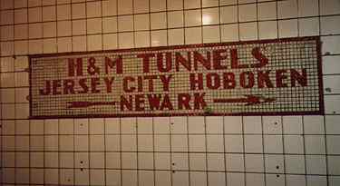
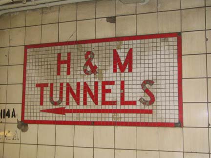
This tiled sign points to the PATH train in the IND station at 14th Street and Sixth Avenue. The PATH, which stands for Port Authority Trans-Hudson, used to be known as the Hudson and Manhattan, or H&M.
The PATH goes, now as then, to Hoboken, Jersey City, and Newark.
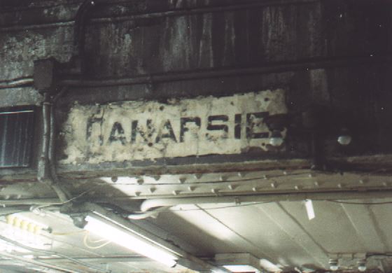
Recent renovations in the Times Square underground complex have uncovered a sign apparently pointing the way to Canarsie. Since the 14th St Crosstown (L) is nowhere near Times Square, what can this sign possibly be doing here?
In 1999 more of this sign was revealed, and it shows another connection to Coney Island. Years ago, subway signs were much more comprehensive than now and offered every possible conection. This sign probably directed people to take the Broadway Line (today’s R/N) to Union Square, where they could change for the Canarsie Line.
By 2000, this sign had been whitewashed.
Photo by Saul Blumenthal. Link to his own excellent NYC subways page here.

1990s renovation in the Cortlandt Street/former World Trade Center BMT station (R, W) has revealed ancient tiled “Hudson Tubes” signs that refer to the PATH.
Back in the early 1900s, there was no standardization regarding signage that pointed to the PATH…it was known as the H&M, the Hudson Tubes and by other names.
This additional sign at 14th Street perpetuates the PATH’s old name.
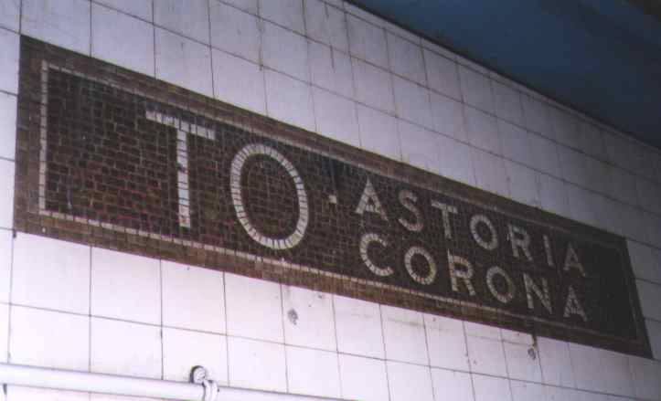
Before being extended to Main Street in Flushing in 1928, what’s now called the Flushing Line, or #7 train, only went as far as 103rd Street in Corona. This sign, in the Hunters Point Avenue station at 49th Avenue and 21st Street in Long Island City, dates from the 1920s.
2000: sign has been obscured.
2012: after a station renovation, it’s in the clear again!


Each of these photos, both taken a number of years ago, demonstrate that NYC subway signage was a lot more informative in years past. Every possible connection at each stop was spelled out in detail. People seem much more hurried these days, so subway signage has been made much less complicated and some say, less attractive. [Transit Museum auction, 1988.]
“Coke Adds Life” photo courtesy of Mary Beth Henry.


In 1999 I uncovered a real find at the 57th Street IND station on 6th Avenue.
A mid-1970s Transit Authority map is still in place, albeit behind a modern map and shielded behind plexiglass!
Designed by Massimo Vignelli and first seen in the late 1960s, the former Transit Authority map was decried for its physical distortions and its difficulty to read. It was replaced by the current design in 1978.
[2012: everything old is new again…the MTA’s ‘weekender’ map, showing the many changes in rail service, is patterned after the Vignelli map.]
The first edition of NYC Access, which came out in the early 1980s, featured this unique subway map designed by Vignelli and based on his earlier design.
Vignelli has harsh words for the current map in NYC Access:
The present map may be clearer in some instances, but in toto, is a disappointing solution. The overall design is unclear and messy, which is unfortunate, since cartography has advanced to a much finer stage than the map would imply…


A couple of anomalies along the IND Crosstown (G) line. The misspelling at Broadway has been there since the line opened in 1933. The toilet sign at right has been at Bedford-Nostrand for almost as long. The actual photo now points the way to Your Webmaster’s toilet in his apartment.
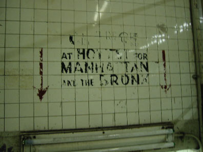
A double anomaly occurs at the High Street IND station: Fulton Street at this point has been known as Cadman Plaza West since the late 1950s, while the sign below it pointed the way to the old St. George Hotel, which boasted the world’s largest indoor swimming pool.
Understand? that means you. Especially at Ft. Hamilton Parkway station in Windsor Terrace [sign since removed]
Until 1988 the K train partially assumed the route of the C.
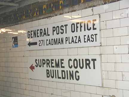
The general post office facilities have decamped the Borough Hall area in Brooklyn for the wilds of Ozone Park, but this handsome enamel sign still points the way, and in fact, you can still go to the old place and mail your letter there.
This sign can be found in the Cathedral Parkway/110th Street IRT station…and since it’s the oldest line in the system, it’s entirely likely that the sign dates to the earliest days of the subway. The line opened in 1904. [it has now disappeared]

The magenta 4/black 5 color scheme was used for a decade or so between the 60s and the early early 80s, when newer signs were phased in. The MTA has hidden them but not quite. Photo: John Oricchio
Jay Street. A connection to the Bronx is not easy from Hoyt Street today, where the A/C (to Ozone Park, Inwood and the Rockaways) and the G (to Cobble Hill and Long Island City) run today. Photo: Mike Epstein


More Hudson and Manhattan Railroad IND signs.
 The Train To The Plane lives.
Leftover G Train entrance on Union Avenue near Flushing Avenue. Photo: Mike Epstein.
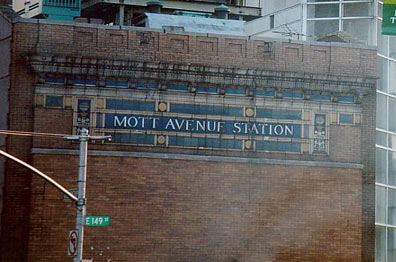
East 149th and Grand Concourse, Bronx
PATH entrance, 33rd Street station
Sources:
NYC Access, Access Press, 1983
10/14/98