A busy, though unfinished, parkway runs through southwest Staten Island, connecting the junction of Richmond Avenue and Arthurkill Road with the Outerbridge Crossing, built in the 1920s as a connection to Perth Amboy, New Jersey. The road has been in existence since 1941 and, for part of its history was one of two major roads named for Catholic priests (though not at the same time*). The name Drumgoole has been associated with the road almost since its beginnings.
John C. Drumgoole (1816-1888) immigrated from County Longford, Ireland, in 1825 to join his mother in America after his father’s death, and took work as a shoemaker when he became of age. He became the sexton and janitor of St. Mary’s parish in Manhattan’s Lower east Side in 1844, the third oldest NYC parish, and took a special interest in the thousands of homeless and orphaned children wandering the streets after coming to America in the aftermath of Ireland’s potato famine of the 1840s, or were left parentless during the Civil War. He provided food and shelter to these destitute youth in the basement of St. Ann’s for 21 years.
Drumgoole had always aspired to the Catholic priesthood and after attending St. John’s College in the Bronx, now Fordham University and the Seminary of Our Lady of Angels near Niagara Falls, he was ordained at age 53 in 1870. He continued to help homeless children in the succeeding years.
In those days tuberculosis and influenza ran rampant in the city’s poorer sections and it was thought that fresh air played a large part in recuperation and recovery. Thus, Fr. Drumgoole sought property well outside of town and in 1882 purchased the land in southwest Staten Island that is now known as the Mount Loretto orphanage.
Fr. Drumgoole was a great innovator in the field of childcare. The layout of the Mission was designed to provide plenty of light and air to each resident so as to avoid the spread of influenza and tuberculosis, which was common in the tenements of the day. Fr. Drumgoole felt that the general environment of the City at the time was a great threat to younger children, so he sought out a more rural setting. He looked to the Borough of Staten Island and found a farm for sale that must have reminded him of his earliest years in County Longford, Ireland. With the purchase of this and several adjacent lots, Fr. Drumgoole founded Mount Loretto, named as a tribute to the Sisters who accompanied him there to teach the children on a completely self-sufficient farm. Mt. Loretto
In March 1888, Fr. Drumgoole died during an illness acquired when he was caught out during the Blizzard of ’88 that month.

During the 1930s, plans were drawn up to construct a major parkway in southwest Staten Island. At that time, Arthurkill and Amboy Roads were rutted farm-to-market roads, still unpaved in spots.
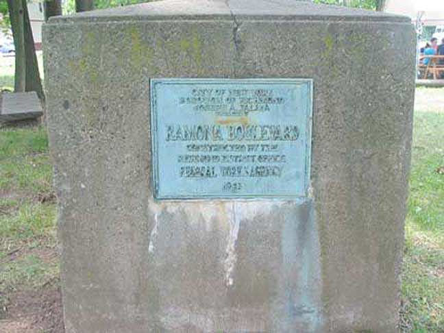
A concrete slab containing a plaque dated 1941 in Richmondtown Restoration proclaims the existence of Ramona Boulevard, “constructed by the Richmond District Office, Federal Works Agency.” This is the genesis of the parkway, which, as Steve Anderson reports in NYC Roads, was planned as early as 1930 and its first incarnation, as a surface road named Drumgoole Boulevard, was built in the 1940s, with the present sunken parkway arrangement completed in 1972.

In this photo from the Staten Island AD’vance archives, dated January 1941, we’re looking at the opening of Ramona Boulevard, with the roads still awash in slush and the Woodie posts yet to have their gumball luminaires attached. We are looking east from Huguenot Avenue; here the road takes a NE bend toward Richmond Avenue.


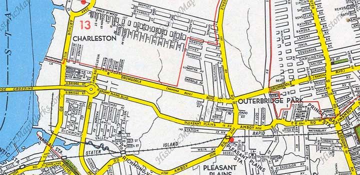
This trio of plates from a 1949 Hagstrom atlas shows the extent of Drumgoole Boulevard, for which Ramona Boulevard was quickly renamed, running from Arthurkill Road and Richmond Avenue southwest and west to Arthurkill Road near the Outerbridge.
During an early-1960s bus jaunt to southwest Staten Island I recognize seeing Drumgoole Boulevard, which was still a 4-lane local access road, though major by Staten Island standards at the time.

In the 1960s, traffic czar Robert Moses had big plans for the little parkway named for the founder of Mount Loretto. He would turn it into a major vehicular parkway, sink it in an open cut to avoid traffic signals and connect it to the Outerbridge on the west and then bruit it northeast through several Staten Island communities to flow into the Staten Island Expressway near Clove Lakes Park.
Moses got most of his plans completed, with the new Richmond Parkway opening in 1972 on Drumgoole Road’s old route from Richmond Avenue west to the Outerbridge. In the 1990s, Richmond Parkway was renamed Korean War Veterans Parkway.
As for Father Drumgoole, his name is preserved on the service roads from Richmond Avenue west to Bloomingdale Road.
Moses was stymied, however, in getting Richmond Parkway to connect with the SIE. The road would have been thrust straight through the Staten Island Greenbelt, and the neighborhoods’ opposition to this, plus the city’s precarious finances in the 1960s and 1970s, precluded such an expansion. The approach ramps to Richmond Parkway were, however, built, and enough land was excavated to build a recreational hill known as Moses Mountain in LaTourette Park.
Though urban explorer Nathan Kensinger chronicled the remains of these traffic ramps in 2011, since then the ramps, as well, have been torn down.
1/19/15
*The other major road in Staten Island named for a Catholic priest is Father Capodanno Boulevard in South Beach, named for a Vietnam War hero.


17 comments
It is not just “The Outerbridge”. To be clear, the correct name for the bridge at the end on the KWV parkway is Outerbridge Crossing, named for the first chairman of the Port Authority.
http://en.wikipedia.org/wiki/Eugenius_Harvey_Outerbridge
Technically, you’re correct Joe, though most Islanders call it “The Outerbridge” and hardly ever use the “Crossing” part. Funny that the first chairman of the PA was named Outerbridge and had a bridge named after him. The “Crossing” part was added so folks didn’t think it was some “Outer Bridge” on the outskirts of town (which actually it is, it being the southernmost bridge in both NYC and NY State).
Well done Kevin. Just an FYI: Arthur Kill road is two words, not one (Arthurkill).
My maternal Grandfather worked on the construction of Ramona Blvd. under the WPA as well as the club house in Clove Lakes Park and other WPA projects. My maternal side were long time Staten Islanders. Grandpop always referred to the subject road by the original name no matter how many times we told him that the name had been changed.
DId your word processing program perhaps convert “Arthur Kill Road” to “Arthurkill Road” as it appears consistently throughout your post? The north-south road runs along the Arthur Kill, the channel that lies below the Kill Van Kull.
I remember Drumgoole Boulevard as it was in the late 1950s. The now defunct St. Louis Academy was set back from the boulevard near its intersection with Bloomingdale Road. The whole area was green, then, some of it still rural. We lived on one of several working farms that lay along Bloomingdale Road. Some of the nearby back roads all wooded except for an occasional house, were traveled on foot as much as by vehicle. Development has wiped it all out.
Kevin, Moses Mountain was originally a giant pile of construction debris from the Staten Island Expressway, deliberately deposited there to support a giant cloverleaf interchange of the Richmond Parkway, the Great Kills Parkway and the Willowbrook Parkway… unimaginable today if one stands at the bucolic corner of Rockland Avenue and Manor Road, where the cloverleaf would have been overhead.
used to sit on top of moses mountatn after riding our harley sportsters up it , what nerve we had in youth.
I’m quite amazed to see Woodies on Staten Island, which indicates the very early plans to make Drumgoole Boulevard a full-fledged Parkway. Of course, by the time Richmond Parkway opened, Woodies were on their way out.
I GREW UP on Vineland Ave in the 1960’s -early 70’s.
on the Hagstrom map plate above – the middle one – there were many, many blocks of long-demolished houses on near-dirt roads centered about where the red “12” appears, between Jefferson Ave. and Nippon Ave.
i would walk these roads as a kid and easily imagine a POST-APOCALYPTIC WORLD, as the streets were littered with burnt-out car hulks and abandoned appliances.
DOES ANYONE KNOW the story behind this area? the 1949 map above indicates several roads that simply were not there by the 1960’s.
was this an area evacuated for a Moses project or something more sinister, like a secret 1950’s superfund project?
P.S. we called the abandoned roads in the comment above the “Cooney Roads” because someone with that name lived on the eastern edge, i think on Heenan Ave.
BTW we frequently played on the then-new SIE traffic ramps-to-nowhere by Al Deppe’s corner (intersection of Richmond Avenue and Arthurkill Road) and even once walked nearly a half-mile through a five-foot tall drain pipe that started somewhere around Annadale Rd. – i was 11 years old and never been so scared – nor so happy to see light at the end of the tunnel.
They had to weigh prudently the positive and negative aspects both of completing the final leg of the once proposed and controversial Richmond Parkway. It is today officially demapped and terminates at Richmond Avenue, going North and connects to the Outerbridge going South. In the 1960’s, traffic was a fraction of what it is today in the area, and the South shore was largely undeveloped woodlands. A two lane highway, going in each direction through the Greenbelt would certainly not have destroyed the vast woodlands there and was an absolute necessity looking forward and planning for the future of mass housing development and the population explosion in the area in the coming decades. Traffic has no where to go from North to South and creates huge traffic and pollution problems;far worse than the planned 4.7 link of roadway to connect North and South there. In fact, a roadway passing through Latourette Park and the Greenbelt towards the Verrazanno Bridge North or Outerbridge bridge South would have also created a beautiful and panoramic natural route through undisturbed woodlands to view that would have been unparalleled in New York city. Sadly, this can never be due to the short-sightedness of conservationists and misguided politicians so long ago.
we used to party on the ramps by community college in the early 70’s
What a great story. Father John Drumgoole was brilliant in all the projects he completed to help the poor Irish children.
Only a Saint could do that. We are al proud of what he did. Thank God their are a few amongst us that are concerned and helpful to others.
They took my grandparents house,even though they never used the land later allowing someone to develope it . Always was sour about it .Take it if you must not because you can.
Do you or your family have the documentation? Was just compensation paid? Under the takings clause of the fifth amendment of the U.S. Constitution, and the due process clause of the fourteenth amendment, land cannot be taken without just compensation and given to somebody else (not legal advice, just info).
Had never heard of Ramona Boulevard in all my years of the island. It that marker still there? Where?
Still at Richmondtown.