
Perfectly cantilevered buildings mark the intersection of Amersfort Place and Campus Road in the shadow of Brooklyn College. After discussing Hillel Place yesterday, I have another bit of business to take care of today at another nearby obscure named street, Amersfort Place.
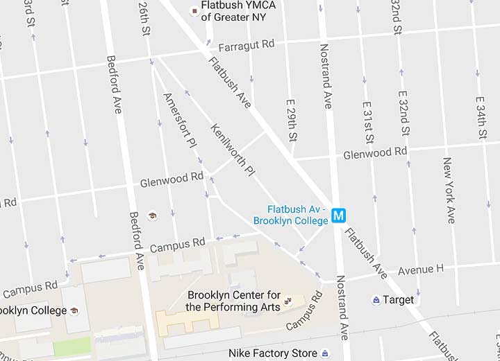
This modern Google map shows Amersfort Place, which oddly angles its way from Farragut Road and East 26th Street south and southeast, finally meeting Campus Road west of Nostrand Avenue.
Here’s a tip for ancient street sleuthing. Often, a lengthy major roadway will be paralleled in spots by a shorter lane that sort of meanders or wanders. In many cases, such a short meandering road will be a leftover portion of that selfsame major road before it was widened and straightened. For example, Trotting Course Lane in Forest Hills is a tiny part of the same road that became Woodhaven Boulevard. Meanwhile, twisting Old Amboy Road in Eltingville is an “early” version of Amboy Road. The list is short but noteworthy.
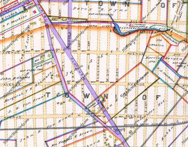
Here’s a portion of a map of the town of Flatbush in Kings County in 1890. Everything here became part of the City of Brooklyn by 1896 and the City of New York by 1898. The only paved roads are marked in purple.
At the time, Flatbush Avenue had recently been straightened and graded from what was known previously as the Old Flatbush Road and decades before that, Kings Highway. However in 1890 a leftover curve in the road had also been paved. This angled path is today’s Amersfort Place.
“Amersfort” is a fairly well-used Brooklyn name. Like Utrecht, it is Dutch in origin. It’s also used for Amersfort Park, a full city block in East Flatbush defined by Avenues I and J and by East 38th and 39th Streets.
Amersfort Park is a pleasant surprise if you’re passing through. It is atypical of NYC neighborhood parks in that there are no athletic fields or even jungle jims or swings — it’s just a pleasant green space with lawns, paths and benches. A former name for Flatlands is “New Amersfort” and the decorative stone monument in Amersfort Park is a copy of a 200,000-year old rock found in Amersfoort, Holland. The nickname for Amersfoort, Keistad (stone-city), originates in the Amersfoortse Kei, a boulder that was dragged into the city in 1661 by 400 people because of a bet. This story embarrassed the inhabitants, and they buried the boulder in the city, but after it was found again in 1903 it was placed on a prominent spot as a monument. The town is a province of Utrecht, from whence many colonial-era Dutch settlers hailed, and the namesake of New Utrecht Avenue in Borough Park.
There had even been a third Amersfort in Brooklyn… the former Amersfort Avenue, which ran for a block from Avenue T at East 53rd Street south to Flatbush Avenue at Avenue U. In a true puzzler, after the nearby Kings Plaza Shopping Center opened in 1970, the then-Department of Traffic renamed it as a southern continuation of East 53rd Street, and the older East 53rd between Avenues T and U was then renamed East 53rd Place. Why the DOT didn’t leave well enough alone is beyond me.
8/3/16
1 comment
When was it built and by who