
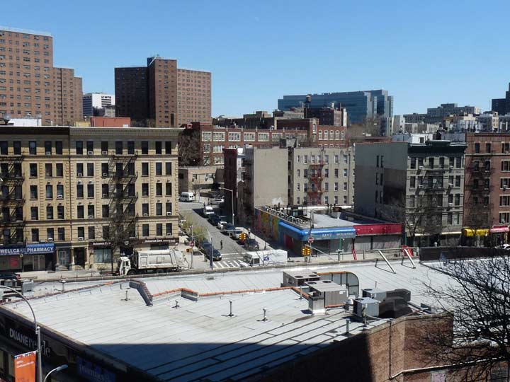
I had an interregnum of work this past spring (2018), the better part of two months for a financial printer in Midtown. The hours were overnights from 12 to 8, though, and it played havoc with my sleep schedule — I could not really sleep that much during the day and would make up for it on weekends and overnights. During that time, though, I was able to get out for a monster walk, 8-10 miles, from Manhattanville east to Hunts Point in the Bronx, where I had not been for nearly a decade. The two coordinates are fairly easily attained on foot by using East 145th and Westchester Avenues, and I stuck to those routes, veering off when there was something nearby of interest. And, the cool clear weather was prime for photography; the summer that followed has been a humid, murky mess.
This particular series may have multiple parts, since I’m trying to find a way to do shorter posts despite getting 257 shots on this particular walk.
GOOGLE MAP: MANHATTANVILLE TO HUNTS POINT
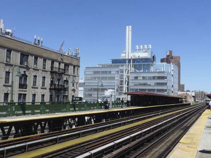
I took the #1 train to the elevated 125th Street platform, the only elevated train station in Manhattan south of Inwood. In 1900, subway engineers had a choice: make the subway go deeper to accommodate Manhattan Valley, where Manhattanville is, or keep the train level and place it on a trestle. They chose the latter and built one of the highest and most spectacular elevated stations in New York City.
The view from the station is a bit different now because of new buildings that have recently been constructed for a new Columbia University Center in Manhattanville, which is about half completed. The new Jerome L. Greene Science Center (see below) dominates this view looking north.
I snapped this view of a short street called Old Broadway from the platform. It runs in two pieces between East 125th and 129th just east of the “real” Broadway. It’s a remnant of the old days. Before the late 1800s, what became Broadway was a meandering route called Bloomingdale Road, which went to the village of the same name. During the Boss Tweed era in the late 1800s, the road was straightened with a center garden median, with the whole thing from 59th Street to Harlem called The Boulevard and then Lafayette Boulevard. Finally the whole stretch became Broadway by the time Greater New York was created in 1898.
However, some isolated bits of the old meandering path still exist as Old Broadway and Hamilton Place (again, see below).


The 125th Street still has its original 1904 railings as well as lamp stanchions. In the 1990s or early 2000s, yellow sodium high-intensity lamps on looped masts were placed on top of the old shafts. Here’s a vintage photo showing the old stanchions, as well as the old wooden platforms!
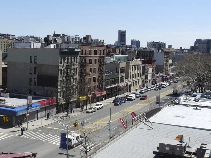
125th Street, a.k.a.Martin Luther King Jr. Blvd., runs from the West Side Highway (Henry Hudson Parkway) east to the Triboro Bridge. In Manhattanville it was once called Manhattan Street. There is a much shorter Manhattan Street in the Lower East Side, so Manhattan once had two Manhattan Streets and a Manhattan Avenue. There’s also a Manhattan Avenue in Brooklyn.
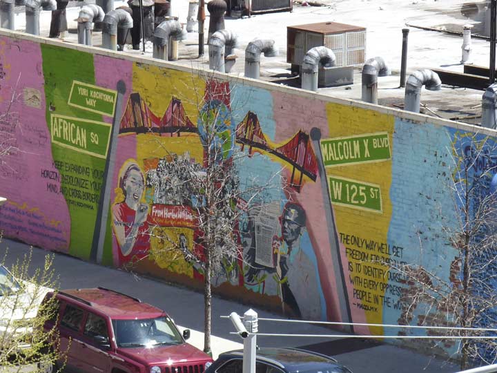
Mural seen from the platform; Malcolm X Boulevard is Lenox Avenue, which was 6th Avenue, so all the street’s names have had an “x” in them. Surprisingly the street signs and font are expertly rendered.


The very high 125th Street station, some of the most impressive elevated structures in NYC. As we’ll see, another one is just a couple of blocks away. You have your choice of an escalator, or for a cardio challenge, the staircase. Here’s a vintage look from the early 1900s, before there were escalators.
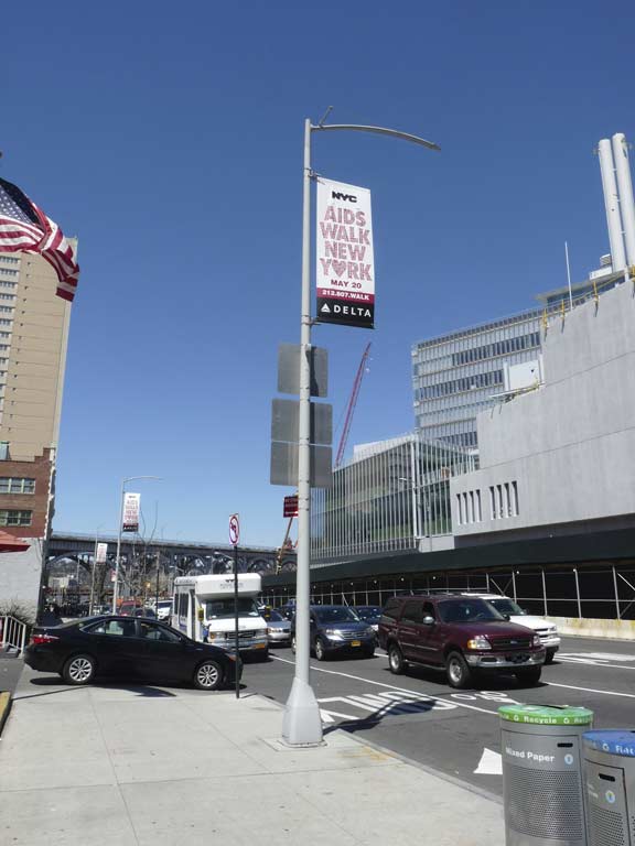
An international design competition to develop a new streetlight for New York City was held in 2004. The City Light design was selected as the winning entry. They have been seen a great deal in Manhattan lately: 125th Street has gotten a set, as well as 2nd Avenue on the Upper East Side, 23rd Street, 7th Avenue and Times Square, and other spots. I call them the Harpoons, due to their resemblance to the fishing weapon.
A set of bright white Light Emitting Diode lamps are installed along the shaft, which is mounted on a cylindrical pole and a base with an uneven, slanted apex.
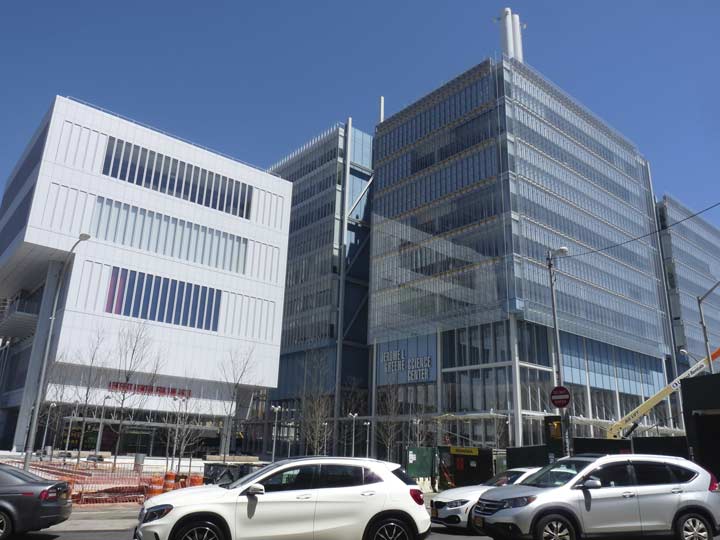
Two new Columbia University buildings along the north side of West 125th Street: the Lenfest Center for the Arts and the Jerome L. Greene Science Center.
The Science Center was designed by architect Renzo Piano (of the NY Times building on 8th Avenue) and constructed with the aid of a $250M grant by the Jerome L. Greene Foundation (a prominent Columbia U. graduate, philosopher and investor) to host the university’s neuroscience labs. The new building will serve as the home to over 800 scientists and researchers, from undergraduate students to world-renowned specialists. It also includes a community education lab and wellness center.
The second building in Columbia’s Manhattanville campus to open, the Lenfest Center serves as a venue for exhibitions, performances, screenings, symposia, readings and lectures, and contains new state of the art screening rooms and art galleries. It was also designed in association with Renzo Piano and was built with the aid of a grant from university trustee Gerry Lenfest.
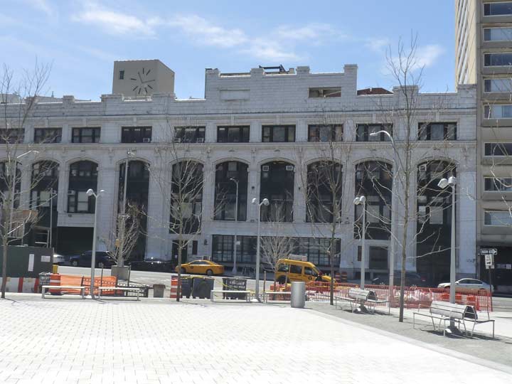


The Sheffield Farms Dairy Building on the south side of West 125th was designed by Frank A. Rooke — a specialist in stable and industrial architecture — with a pure, gleaming front of white glazed tile, and trimmed with copper windows and other details, oxidized to green. The Sheffield dairy had a copper and glass overhang over the central section, shielding delivery wagons from the elements. The milk cans were emptied on the top floor in a dust-free room: the windows were double-glazed, and air pressure was kept higher than that outside, so air was constantly flowing out.
Milk flowed down through filters and pasteurizing equipment until bottled and sealed at the ground-floor level. Ice was dumped into the screen-bottom milk crates, which were transferred to delivery wagons moving through a half-oval path on the interior, entering on the right side of the building and exiting on the left. Sheffield Farms president Loton Horton opposed pasteurization, but this plant included the process.
The processing facility was purchased by Columbia University in 1949 and renamed Prentis Hall. It is the survivor of a number of milk processing plants once located in Manhattanville. The “God Hates Guns” on the window was a production at the Lenfest Center in the spring of 2018.


Seen here are a couple of newer lamppost styles in the area: davit, or curved-shaft lamps, on West 129th Street and the new twins that illuminate the public plaza in front of the Lenfest Center.
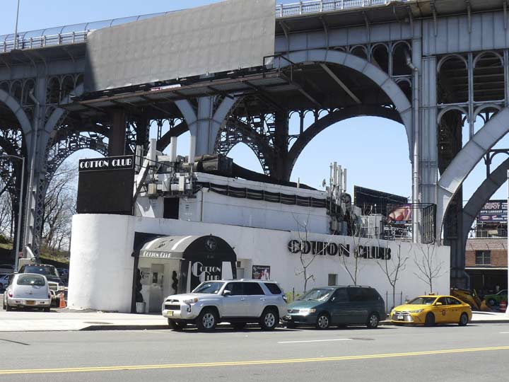
The present incarnation of The Cotton Club is in the triangle formed by West 125th, St. Clair Place, and Riverside Drive. The original, opened by famed boxer Jack Johnson in 1920 as the Club DeLux, was situated at Lenox Avenue and West 142nd Street; it was renamed by new owner, gangster Owney Madden, in 1923. The club helped launch the careers of Fletcher Henderson, Duke Ellington, Cab Calloway, and many other jazz and pop stars of the 20s and 30s. The original Cotton Club closed in 1936, with a second incarnation at Broadway and West 48th Street from 1938-1940. A new Cotton Club reopened at its present location in 1978 and is presently owned and operated by John Beatty.
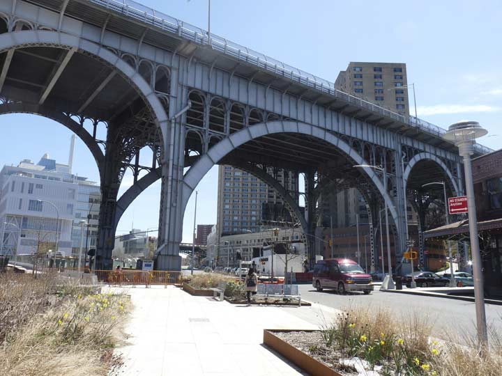


Another of Manhattan’s magnificent steel elevated structures is the Riverside Drive Viaduct, which takes the roadway over Manhattan Valley just as the IRT elevated takes the subway.
The viaduct was constructed in 1900. The metal arch spanning West 125th Street measures 130 feet in width. Looking down 12th Avenue (the avenue was “reactivated” here for the road under the viaduct; the southern part of 12th Avenue ends at West 59th Street) the metal arches seem to stretch into infinity. The view has been used in dozens of motion pictures and commercials. After a fire, it was rebuilt in the 1980s.


A recent renovation has removed remnants of the Manhattan’s trolley system, which was unique in that the trolleys didn’t take power from overhead wires, which were illegal in Manhattan. In Manhattan local laws prohibited unsightly overhead trolley wires, and so street railways had to take power from electric conduits located beneath the pavement. Streetcars had a thin arm, called a plough, that extended into a below-pavement channel containing a charged rail with up to 600 volts (the same juice that subway third rails of today carry). The rail was placed between the two rails that carried the wheels.
Till just recently, a stretch of original cable car tracks could be seen amid the Belgian blocks under the viaduct at 12th Avenue and St. Clair Place.
The present “homage” is nice to have included a recollection of the tracks–but can’t match the real thing!


Before it reaches the Hudson River West 125th has to pass beneath two more elevated trestles, one carrying Amtrak passenger trains, the other carrying the Henry Hudson Parkway. Here I found one of the last remaining Westinghouse incandescent “cuplights” though I don’t know if it still works.


At the Hudson River I “discovered” a relatively new park, West Harlem Piers Park, opened in 2008 and finally completed in 2014. It is a concentrated area of Riverside Park on a former parking lot at what was once a busy 19th-Century ferry terminal. I strolled out onto the new pier and took in the view up and down-river. Docked at the pier is a World War II-era vessel, the Baylander, a former Vietnam War-era US Navy freight and equipment lander that also served as a helicopter landing trainer. It is owned by the Trenk Family Foundation and is open to visitors on a limited basis. It’s hoped that it can become a floating museum, since all its working parts have been retained, or perhaps a cafe.


The Fairway Supermarket, a longtime Manhattanville staple, occupies several very old buildings along 12th Avenue under the Riverside Drive Viaduct. The area isn’t landmarked, and I’m a bit frustrated about not being able to find a great deal of information about these structures. One has an intriguing concrete logo with an arrow and a letter S. If you know anything, fill me in in Comments.


This brick building at 2331 12th Avenue, now the Solomon & Kuff Rum Hall, continues to advertise its former status as Contract Packers. The old business occupied this building between 1947 and 1961.


Studebaker automobiles were made in South Bend, Indiana and in Detroit (depending on the year) and were shipped to a number of distributors around the country where they were stored and eventually shipped to individual dealers. The Manhattanville building doubtlessly included a number of large freight elevators for moving cars from floor to floor and I suspect that the tower housed elevator machinery, maybe in addition to other things. In addition to the car storage areas, the building almost certainly included regional sales offices, an extensive parts warehouse, and dealer/mechanic training facilities.
The exterior has been restored in the past two years by Columbia University. The original windows were all replaced by matching new windows. This was originally a Borden’s milk processing plant.
There are other Studebaker distributorships around town–in Jamaica, and spectacularly, on Bedford Avenue in Crown Heights.


At West 133rd Street, Broadway begins its climb out of Manhattan Valley and the IRT subway is bridged over it in a somewhat more modest fashion than at West 125th, but when it was built in 1904, it was still the Beaux-Arts era and ornamentation was everywhere, including the concrete festoons on either side of the trestle. I got the shot of the tacks from the West 135th Street overpass that goes over the tracks.


The Claremont Theater at Broadway and West 135th, possibly Manhattan’s oldest extant movie palace, opened in 1914. The white terra cotta theater was designed by Gaetan Ajello (1883-1983). It has been used as a movie theater, dance hall, auto showroom (as early as 1933!), roller skating rink, retail shops, and presently, for self-storage.
Thomas Edison filmed a crowd exiting the Claremont in 1915.


Hamilton Place, another remnant of the Bloomingdale Road, diverges from Broadway at West 136th and forms a triangle park at West 137th Street.
The park was created in 1906 and named after Sir Moses Haim Montefiore (1784-1885), a wealthy Italian-Jewish businessman who donated large sums to Jewish industry, economic development, education and health care. The Bronx’s Montefiore Hospital and Queens’ Montefiore Cemetery are also named for him.


Information on the Disciples of Christ Church at Hamilton Place and West 139th is hard to come by. But the exterior is unusual: a facade wrapping around a much older building on the corner, and an intact stable on 139th now home to a travel agency. Not hard to visualize a grand mansion at one time, with its stable in the rear.
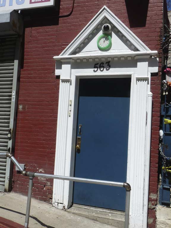
Unusual detail is not hard to find if you have a keen sense for it. I noticed a small clock, with the correct time, embedded in the pediment of the doorway of the former stable.


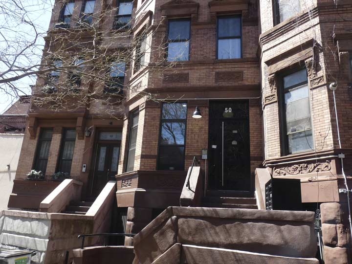
Apartment buildings are often given names; some reflect former street names or are just descriptive of the neighborhood they’re in. Others are not so easily explainable. This pair on Hamilton Place between West 139th and 140th bear the names “Euafaula” and “Talladega.” As it happens, the NYPL has a floor plan in its collection. Both Eufaula and Talladega, home of the NASCAR racetrack, are towns in Alabama — so, we can infer that the early 20th Century developer may have been from the Yellowhammer State.
Triangular fronts at 48-52 Hamilton Place, constructed to catch the sun at certain times of day.
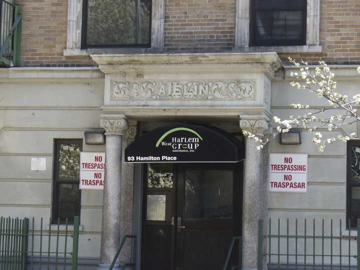
93 Hamilton Place, The Aelin. This one is not so easily etymologized. Perhaps the name just sounded good to the developer.
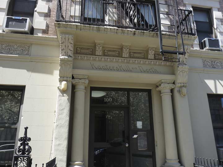
Kaaterskill is a tourist-attracting waterfall in the Catskill Mountains. While ‘kaater’ is meaningless in Dutch, ‘kill’ means ‘stream’, and bobcats can be found in the area near the falls, but that derivation is purely conjectural. The developer apparently wanted to evoke rurality and nature, and this area of Hamilton Heights may still have been heavily wooded when the apartment was built in the early 20th Century.


Here’s an engaging mural by Frank Parga, depicting famed Harlem residents such as Langston Hughes and Duke Ellington, called “Gold Beneath the Surface,” completed in mid-2014, at West 142nd Street at Amsterdam Avenue.
Next time: East 145th across the river
Please help contribute to a new Forgotten NY website
Check out the ForgottenBook, take a look at the gift shop, and as always, “comment…as you see fit.”
9/3/18
15 comments
Kaaterskill is a corruption/Dutch version of Catskill. Kaaterskill Falls is literally “Catskill Falls”
I’m dutch and a male cat is kater in dutch,maybe it was kaater in the 17th century,kater is seldom used anymore,kat or poes(female)nowadays
” Manhattan Avenue, though, is in Brooklyn.”
Manhattan Avenue is also in Manhattan. It runs from W.100th St. to W.124th, where it turns into St. Nicholas Avenue.
I forgot. Will amend.
I work at Columbia U and frequent this area nearly every day.. can’t wait for the next installments as I also live in the Bronx so it will be interesting as I take this very route on a nearly daily basis 🙂
2007’s motion picture, AMERICAN GANGSTER used a large space on the first floor of the Claremont Theater to be an appliance store. The corner of 135th and Broadway can clearly be seen from the building’s interior in the film.
In addition the corner of 135th & Broadway was purportedly, for cinematic purposes, made to be 116th & 8th Ave, Frank Lucas’ (Denzel Washington) main drug corner. They angled the camera to a street sign that said 116th Street & 8th Avenue to give that impression. That gaffe may have fooled many, especially out of towners, but I was wise to it immediately.
The Lenfest Center For The Arts & the Jerome L Green Science Center appear to be very Orwellian. The Kremlin has come to Manhattan & Big Brother commands you to obey.
Re: “The present exhibition is nice to have included a recollection of the tracks–but can’t match the real thing!”
What is the exhibition?
The fake tracks and ‘memorial’ that were placed there when they removed the old tracks and Belgian blocks.
Sheffield Farms was the sponsor of the Pre-Game Brooklyn Dodgers both on TV and the show was hosted by Happy Felton. Also, the Ferry Terminal at the end of 125th Street was privately owned by Public Service Transport of NJ who owned a large trolley and bus terminal at the Jersey side to meet the ferries. As a boy, riding in my Dad’s 1941 Ford on the way to Jersey via the George Washington Bridge, I remember seeing the huge billboards advertising the 125th Street ferry to NJ….
The 125th Street station may be ONE of the highest, but Brooklyn’s Smith-9th Street station IS the highest.
Per Wiki:
“Smith–Ninth Streets is a local station on the IND Culver Line of the New York City Subway. It is located over the Gowanus Canal between Smith and Ninth Streets in Gowanus, Brooklyn and is served by the F and G trains at all times. The station is 87.5 feet (26.7 m) above ground level, making it the highest rapid transit station in the world.”
…and it has great views of the Gowanus Canal (almost like being in Venice!)
.
.
Nice set Kevin.
The Hudson River Day Line also stopped at 125th Street.
.
The USS Baylander has no connection to WWII, but it is a one-of-a-kind ship in history: it’s considered to be “the world’s smallest aircraft carrier” and was used for 25 years to train helicopter pilots from the five military branches in helicopter landings.
It went from being an unnamed Navy ship to a US Army ship(yes, they have ships!) then finally got renovated to become a helicopter training ship. It also is a rare shop that underwent an overhaul and saw it turned around 180 degrees so the bow became the stern!
I have to walk past these mind-blowingly ugly Columbia buildings every day I go to work. Someone got a $250 million dollar grant for this? I am definitely in the wrong line of work. What is the deal with those two smokestacks? At least whoever got the glass contract made out well. I wonder what these buildings will look like in twenty years. The dirt of the city is already attaching itself at street level.
That old building with the S and arrow has been puzzling me too. I could not find anything.
The intriguing concrete logo with an arrow and a letter S may be referring to A. Salmon + Sons Meatpacking that may have occupied the Fairway Building. Unconfirmed, let me know if you find any more information.