Visible remnants can still be found from a trolley line in Canarsie, Brooklyn, at which trolleys last clanged and rumbled way back in 1942.
There’s a catch though–this was no regular trolley line, but it was in turn the last remnant of steam railroad service to Canarsie.
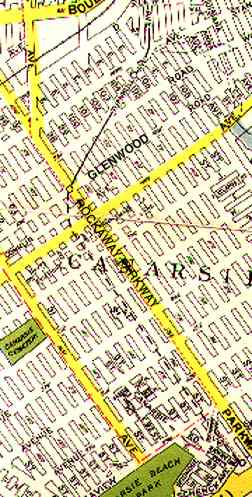
On this 1938 Geographia map of Canarsie, the single black line in the center of the picture represents the BMT Canarsie Line–designated by the letter L today. Then, as now, it ended at Glenwood Road and Rockaway Parkway.
Until 1942, though, a free transfer existed at Rock Parkway that allowed you on a trolley line that traveled on a private right of way between East 95th and 96th streets to its terminus at a long-departed beach resort at Jamaica Bay called Golden City, complete with an amusement park, fishing boat rentals and beer halls.
Let the 1939 WPA Guide to NYC set the scene:
A trolley car extension of the BMT subway runs through a littered lane between the back yards and unkempt gardens of rundown houses. Here and there passengers catch a glimpse of Canarsie’s better dwellings, of its village-like business section on Flatlands Avenue, of great stretches of dump and marsh, and of unpaved streets. In the near future Canarsie will undergo changes as the new Circumferential Highway [Belt Parkway] around Jamaica Bay is completed and the shore improved.
Funny, nowhere else in the WPA Guide is such delicious contempt exhibited toward any other NYC neighborhood. For years, Canarsie was the butt of many Borscht Belt comedian’s japes.
The railroad first came to Canarsie in 1906, when a steam line operated at grade between Canarsie Pier and East New York. Brooklyn Rapid Transit operated the line beginning in 1908, but ended through service to Canarsie Pier in 1920.
nycsubways.org on the Canarsie line:
In the early 1940’s the subway line discontinued the use of the Canarsie Pier terminal, terminating instead at Rockaway Parkway. The Canarsie Pier line maintained trolley service until that was replaced by the B42 bus and the right-of-way abandoned and built over. For the record, this right-of-way ran between East 95th and East 96th Streets as far south as Seaview Avenue.
In 1942, service ended on the private ROW, and the Rock Parkway trolley also met its demise in 1951, to be replaced by bus service.
Tangible remains still exist of trolleying, though, at the terminus of the BMT Canarsie Line (L).
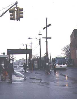
There is a bus terminal at that station that assumes the old right of way of the trolley line. The poles that held the electric power lines for the trolley are still there, and long ago, street lighting was mounted on them, in probably the only instance in NYC this has been done.
RIGHT: Trolley pole with crossbar still stands on Rockaway Parkway south of Glenwood Road.
Note the tilt of the trolley pole in the foreground, and the tall wooden pole in the background, on Glenwood Road just south of Rock Parkway, diagonal to the street grid. They face that way because they still align with the old trolley right of way as it curved south toward East 95th Street.
RIGHT: Another trolley pole, with its crossbar orienting diagonally , is at East 96th Street, leading into a MTA-owned yard.
The NO DUMPING sign (which has been obviously ignored) dates to the 1960s, when the MTA was still known as the New York City Transit Authority. Over 20 years after trolley service ended the MTA owned this yard, which led into the old trolley right of way; the MTA probably still owns it, but who knows what plans there are for it.
There’s been plenty of time to obliterate any trace of the trolley right of way, but this driveway between East 95th and 96th north of Conklin follows the route.
Source: WPA Guide to New York City, published 1939, reprinted 1982 by Pantheon
A fascinating look at Depression-era New York City. BUY this book at Amazon.COM
8/12/01


