
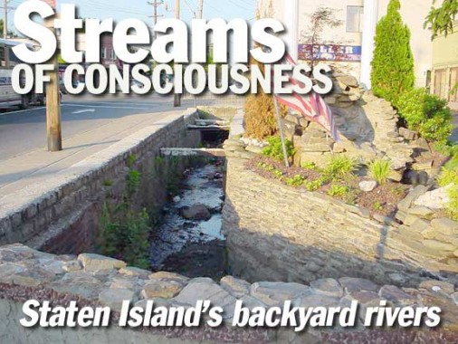
In an otherwise undistinguished bend of Richmond Terrace between the old towns of West New Brighton and Port Richmond, a bridge carries the old Terrace (formerly part of the post road to Philadelphia and originally laid out in 1705) over a narrow creek with just a rusty fence protecting pedestrians from accidentally falling in.
The stream is known as Palmer’s Run and its children can be seen all over West New Brighton and its neighbor to the south, Castleton Corners. These tributaries are mostly contained in sewer pipes these days, but occasionally, they rise to the surface, where they’re taken for granted by the locals but are rather surprising to non-Richmondites who’ve never had to cross brooks and streams on the way to the mom and pop down the street for Cheerios and beer, the breakfast of champions.


Palmer’s Run at Richmond Terrace and Rector Street


On this topographical map section of Staten Island circa 1900, you can see Palmer’s Run in the center, just under the first “L” in Kill.
On this page we’ll concern ourselves mostly with Palmer’s Run which, as you can see on the map, has a number of branches. Of particular interest is the one that runs alongside Watchogue Road and Victory Boulevard (both very old Staten Island roads that go back to Colonial times. Prior to 1918 Victory Blvd. was known as Richmond Turnpike and, as its name implies, it was originally a toll road. It was renamed in honor of the armistice ending World War I). Palmer’s Run, as well as Clove Brook, were harnessed for the mill industry in the 1800s but, as houses replaced farms and mills, the brooks were mostly sunk underground. With some exceptions…


A Palmer’s Run tributary rises to the surface and runs parallel to Victory Boulevard between Perry and Wheeler Avenues, in front of an Italian restaurant named, appropriately, Waterfalls. The creek at Waterfalls is contained in a stone channel.


The creek resurfaces again after a jog to the northwest at Mann Avenue and Marble Street, which is interrupted by the stream at this point.


The creek edges to the northwest at Frederick Street, where it enters the community of Westerleigh, originally known as Prohibition Park and conceived as a ‘dry’ suburb in an island awash in demon rum. Here the unnamed Palmer’s Run tributary is employed for the disposal of nonfunctional or otherwise recalcitrant lawn chairs.
Hereafter, the brook follows a more westerly course just north of Watchogue Road and runs along an intermittent street named Columbus Place. In those blocks where Columbus Place isn’t, you can see what remains of the stream. Then the creek disappears behind a Frederick Street driveway.


At Bidwell Avenue, the relentless Department of Transportation has forgotten to remove a classic Staten Island yellow and black street sign from the 1960s.


We can make a case for the Bidwell Avenue Bridge being the shortest vehicular bridge in New York City. The mighty span carries the avenue over the Palmer’s Run offshoot, which is running in a concrete channel facing the sides of private residences. At this point the brook is parallelling Columbus Place.


A block west of Bidwell, the stream passes Dickie Avenue at grade and so it is necessary to interrupt the avenue, making it a double dead-end. In dry weather, the creek can dry up occasionally. A wooden footbridge carries the sidewalk over the street. It’s a convenient place to leave beer bottles and shopping carts. You know how those wheels can jam.


The most westerly surface manifestation of the unnamed tributary is at Livermore Avenue, where no trace of it can be seen at grade, but the remains of a bridge that used to carry the avenue over it can be detected.
West of here, the stream returns underground where, based on the map at the top of the page, we can surmise that it joins another small creek at about Watchogue Road and Woolley Avenue. That creek joins Palmer’s Run underground at about College Avenue, a little east of Crystal.


Everybody loves Raymond: Palmer’s Run and its attendant brooks are not the only ones that make themselves manifest in the area. Yet another one can be seen about a mile to the east in Castleton Corners. It’s not that easy to find. It’s invisible from the main drags in the area, Victory Boulevard and Manor Road. But a short walk up Raymond Avenue, past the Rite Aid on Victory, will reward you with a charming wooden bridge spanning what, without anything else to refer to, we’ll call Raymond Creek.
Since the 1900 topographical map doesn’t show this creek, I am assuming it flows into nearby Clove Brook, but I could be incorrect about that. I do know that it flows in back of some attached houses along Kimball Avenue but it disappears underground by the time Westcott Boulevard, the next north-south cross street, is reached.

A block to the west of Raymond, South Greenleaf Avenue spans the creek with a metallic bridge, again among New York City’s smallest bridges.


On the southwestern end of Staten Island, I was searching, unsuccessfully, for the Journeay Family Cemetery, which, according to records, is supposed to be at about Halpin Avenue and Carlton Boulevard. It’s a heavily wooded, undeveloped area, which, in the past, has been used as a nature trail, as an overgrown path would indicate. Bisecting it is a winding unnamed brook, which according to topographical maps, has a source in Fresh Kills Creek to the north, passing the West Shore Expressway and the old Fresh Kills dump. What’s more interesting, though, is what this creek does south of here.


The creek parallels and flows under wide Woodrow Road for awhile. Then, it resurfaces in a strange area. Where Woodrow Road meets Alexander Avenue, it comes up in the middle of the road, forcing Woodrow to bisect and then become narrower for about a block.


Between Alexander Avenue and Berry Avenue the creek flows along Woodrow for awhile before disappearing underground. Oddly, at that point, Woodrow immediately regains its lost width.
Sources:
The photography of Forgotten Fan Gary Owen. Gary suggested this subject and photographed many of the scenes from Westerleigh.
Holden’s Staten Island, compiled by Richard Dickenson, Center for Migration Studies, 2002, from the original work by Edna Holden in 1964
9/13/03