

As a neighborhood, Morris Park, located in what’s about the exact center of the Bronx, appears to be one of the borough’s most stable and long-standing, but it’s actually only a few decades old and occupies what used to be a vast racetrack – come airfield -come road racing track; many of NYC’s more “stabler” neighborhoods, such as Sheepshead Bay, Brooklyn, are located where the ponies used to run and automotive pioneers raced.


(LEFT) Morris Park Racetrack Clubhouse; above, Morris Park Racetrack grandstand, both in 1899. from McNamara’s Old Bronx, John McNamara
The name Morris turns up a number of times in the Bronx, primarily from two different families: the Revolution-era Morrises: Richard, who arrived in the 1660s and first settled the South Bronx; Declaration signer Lewis, US Senator Gouverneur, and Robert, who was a 3-term NYC mayor in the 1850s.
The Morris of Morris Park was John A. Morris, whose Westchester Racing Association acquired 152 acres in 1888 on the outskirts of the old Bear Swamp (which was quite literally named) and built a huge racetrack and clubhouse there. As opulent as the racetrack was, though, it was in operation only from 1890 to 1904 (though a vestige of horse racing in the area, the Track Restaurant and Tavern, held down a corner at Eastchester and Williamsbridge Roads some distance from the old track until 1957). The track itself burned to the ground in 1910.
In 1908 the abandoned racetrack became the world’s first formal airfield and the American Eagle, the largest dirigible in history to that time at a full 105 feet in length, was built there, and one of the first gliders, piloted by 17-year-old Lawrence Lesh, was launched from the former track that year. And, in the early 1900s, the old racetrack was also used for speed and endurance races for the newfangled automobile, and a young Swiss driver named Louis once won a gold watch for driving a Fiat a the-record 52.8 MPH there. The driver along with his brother Gaston competed in many road races at the Morris Park track and Gaston won at Indianapolis in 1920. Of course, it was Louis Chevrolet (1878-1941), who ironically sold his share in the Chevrolet Motor Car Company he founded in 1911 to original partner William Durant in 1915, and returned to the racing business, as well as aeronautics. (The gold watch he won had been donated by Walter Chrysler.)
It was not until the 1920s that streets were cut through and houses constructed; the neighborhood was not “completed” until the 1970s!


The portal to Morris Park (by public transportation, at least) is the East 180th Street IRT station, which boasts the most majestic station house in the system. The building, thankfully protected by landmark, was constructed in 1912 as a grand Italian villa station for the New York, Westchester and Boston Railroad that operated between the Bronx and Westchester from 1912 to 1937 (it never made it to Boston) and was subsequently sold to NYC and became the Dyre Avenue Line. Other station houses along the line have survived too.
A short walk west along East 180th Street will bring you to the FDNY Fire Alarm and Telegraph Bureau (right) built 1923 in an Italian Renaissance style. It’s actually in West Farms, a Bronx crossroads that borders on Morris Park, Tremont and Crotona Park.
Morris Park Avenue
Morris Park Avenue marches northeast from the old NYW&B station to Hospital Row (see below) and forms the main commercial spine of the area. Like most of NYC’s neighborhood main drags it has several mysterious items, at least to someone not from the neighborhood


Shot this through a wrought iron fence leading to an auto body shop. One of FNY’s more enduing, or annoying traditions…name that car.
Looks like a 1936 Buick Special, according to some FFs.
The 180th Street/Unionport subway yards, are, of course, closed to the public, but a look through another fence on Morris Park Avenue provides a look at R-26 cars 7774 and 7775. These redbird cars were retired from passenger service in 2003. Cars of much older vintage are also stored there.


Unlike Forrest Gump’s box of chocolates, you usually know what you’re going to get on Morris Park Avenue.


New York City is nothing more than a collection of small towns and most New York neighborhoods are blissfully non-suburban in the sense, to put it simply, that all sorts of things are right next to each other. If you want to take your kid to chess lessons in the morning, he can walk across the street for boxing in the afternoon.
(LEFT) Wonderfully non-politically correct name for a movers.

Unionport Road, connecting Bronx Park and the old Bronx town of the same name (now a part of Castle Hill), runs past Morris Park Avenue and officially divides the neighborhoods of Morris Park and Van Nest. (Unionport was originally a sheep pasture and the road has been called Sheep Pasture Road in the past.)
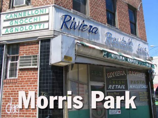
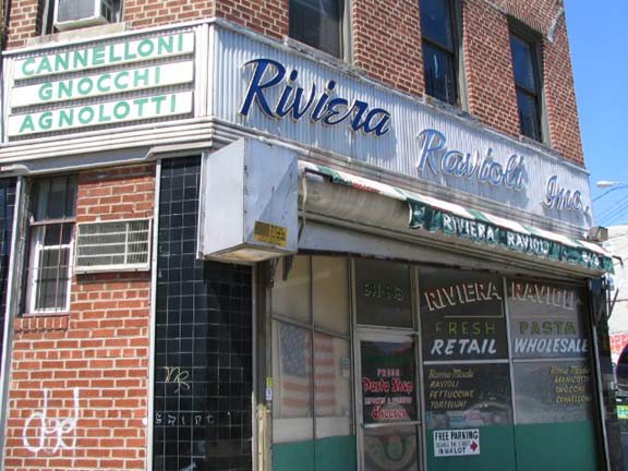
Anchoring the SW corner of Unionport Rd. and Morris Park Avenue is this long-standing pasta wholesaler.
Know your pasta: cannelloni means “large pipes” or large reeds” in Italian and are tubes filled with flavorful fillings, more popularly “Mannicotti” in the USA.Gnocchi, pronounced approximately nyo’ kee, literally “lumps,” small dumplings made from a mashed potato and flour mixture with some egg as a binder; and agnolotti (an yo lat’ ti), “priests’ hats” are a variety of ravioli.
If I’m wrong about these descriptions…hit me with a wet noodle.


When Italian-Americans in the Bronx are mentioned, the guidebooks will usually direct the reader to Arthur Avenuein Belmont, famed for its many restaurants and delicacy shops, but Morris Park and Middletown, to the northeast, are not to be outdone and Morris Park Avenue is lined with pizza places and pasticcerias.
The flags are left over from the celebrations when Italy won the World Cup in July 2006.
http://www.youtube.com/watch?v=lDsqDqh_IxQ
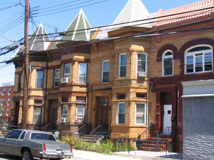

One of Morris Park’s little surprises is this peaked trio on Amethyst Street just off Morris Park Avenue.
Hospital Row


Ullmann Research Center at Newport Avenue (right) is part of Yeshiva University’s Albert Einstein College of Medicine.
Jacobi Medical Center, on a vast plant between Pelham Parkway, Eastchester Road, Morris Park and Seminole Avenues, is the Bronx’ largest public hospital. Also in the Bronx’ Hospital Row are the Bronx Psychiatric Center, Montefiore Medical Center on Eastchester Road and Calvary Hospital, where your webmaster’s father rested comfortably in his final days.
ForgottenFan Michael Szmyga: Where you refer to Jacobi Medical Center, there is a picture that shows a prominent grey building with lighter grey and red buildings in the back. The dark grey building is actually the Rose E. Kennedy Center which is a neuroscience research building part of the Albert Einstein College of Medicine (I’m actually a graduate student at Einstein, hence my now living in Morris Park and knowing which buildings are which). The two buildings in the background are Jacobi Medical Center itself with the red one being the recent addition that opened ~2006.
White Plains Road
White Plains Road, like many NYC streets, is named for a town where it doesn’t go, at least not any longer. It’s the only street in the Bronx that runs from the East River all the way to the city line at Mount Vernon, Westchester County. It doesn’t go to White Plains proper…it changes to West 1st Street in Mount Vernon, but make a turn or two and you will arrive at NY Route 22, known as White Plains Post Road much of its length, which leads to the titular town. In fact, the Bronx’ White Plains Road was laid out in 1863 and was named for fields of bright balsam flowers found along its route.


There are no pastoral scenes left along White Plains Road, but there is this brilliant aquamarine building at Rhinelander Avenue. A close inspection reveals its original function as a garage.
Probably not for your webmaster though. Exercise causes him pain and injury.


Cruger Avenue between White Plains Road and Bronxdale Avenue featured the boyhood home of ubiquitous TV personality Regis Philbin. But what would Reege say if he saw that the Department of Transportation has installed his sign on the wrong street?
photo via Cityrag
Bronxdale Avenue
An Indian trail led through the farms belonging to the Fowler family in Revolutionary times, skirting Bear Swamp, which did in fact feature ursine mammals in the era. It led from the town of Westchester (now Westchester Square) to what is now Bronx Park and later carried the appallation Snuffmill Lane, since at the end of the road was the tobacco-producing Lorillard family’s mail built in 1840, now part of the New York Botanical Garden. Bronxdale Avenue is one of the few roads even at present between Morris Park and Westchester Square, which are separated from each other by the tracks of the Metro-North RR and Amtrak.


On either side of Bronxdale Avenue and Antin Place are the magnificent Art Deco Bronx Park Medical Pavilion that formerly fronted a swimming pool, and a turreted Tudor tower. Walk up Cruger Avenue for some more Art Deco which rivals the Grand Concourse’s collection.


We pause from the great Art Deco to point out these tiny bungalow-like homes on Hunt Avenue just around the corner. Forgotten Fan Don Gilligan surmises they could have housed trackworkers who built the NY, Westchester & Boston RR.
Here I go again..my, my, how can I resist Mamma Maria on Bronxdale and Morris Park Avenue. I haven’t been inside but this place looks huge. 9/19/10: Now known as 900 Park
Forgotten Fan Charles Ferrari writes:
The Mamma Maria restaurant is actually just part of a shopping complex on the corner of Bronxdale and Morris Park, which was built about 10-15 years ago and has gone through some interesting turf wars. If you look at the bottom floor you can see a place called “For Kids Only” which is a daycare center. Originally, each storefront was a separate store, with Mamma Maria and For Kids only being two of them. Slowly, For Kids Only began to expand until it took up most of the building leaving only Mamma Maria and a Cafe. Then suddenly, I come back from college this summer to see Mamma Maria taking up the whole thing.
Barnes Avenue
The Bronx contains some long streets. There’s the aforementioned White Plains Road, there’s Tremont Avenue which runs from the Harlem River to Throgs Neck, Jerome Avenue, and Boston Road, which does go to Boston. Then there’s Barnes Avenue, which begins at a trickle at a dead end past Van Nest Avenue in Morris Park and runs north to the city line at Mount Vernon…at a trickle. In fact Barnes Avenue is interrupted many times on its journey and contains four separate sections, the longest and widest being from Astor Avenue north to Bissel Gardens in Wakefield.
Like most of the Bronx’ long streets it began life as a Native American trail, and has been known in several sections as Kingsbridge Road, White Plains Road (no connection to the other one), Cedar Street, and Madison Street. It’s likely named for 1840s landowner Samuel Barnes, through whose farm part of the route was built.


Like the Tudor shown above at Bronxdale Avenue and Antin Place the avenue’s angle through the area has produced buildings with distinctive triangular shapes that resemble the prows of sailing vessels such as this one at the SE corner of Barnes.
Just south of Bronxdale on Barnes we find this brilliant yellow building with a bright, enclosed porch.


Morris Park contains two of the Bronx’ obscurest alleys, visible on only the most detailed maps, Barnett Place off Barnes Avenue between Rhinelander and Morris Park Avenues. As short as it is it does contain two handsome 2-story brick apartment buildings.
Carpet store sign, Barnes and Morris Park Avenues.


The other obscure Morris Park alley is Graham Place, which is a trickle of sidewalk leading north from Morris Park Avenue east of Matthews Avenue leading to a single house.
More Bronx alleys can be found here, here and here.
Turkish Cypriot Mosque, Morris Park Avenue and Graham Place.


The DOT has been doing a little lamppost experimentation along Morris Park Avenue (along with parts of Williamsbridge Road) in taking double-shafted telephone-pole mounted masts, painting them black and equipping them with neo-Bell mercury bulb luminaires. (Historically in NYC the double masts have always used Westinghouse “cuplights” at first, then Westy silverliners and GE M400s). First installed in about 2003, this style has yet to catch on elsewhere around town.
A group of streets in Morris Park along Jacobi Hospital sport Native american names: Seminole, Pawnee, and Narragansett. Originally these streets were part of a real estate development called Westchester Heights in the 1860s, and the developers decided to give the streets Indian-sounding names (Seminole was originally Saratoga Avenue.)
Pelham Parkway


The greenway/parkway known officially as The Bronx and Pelham Parkway (sort of like The Grand Boulevard and Concourse) runs from Boston Road east to Stillwell Avenue, connecting Bronx and Pelham Bay Parks, after which the greenway ends and the road becomes the Pelham Shore Road, running through Pelham Bay Park. Though not constructed by Frederick Olmsted and Calvert Vaux, the designers of Brooklyn’s Ocean and Eastern Parkways, it follows their model of the parkway in its true sense; a park along which traffic runs. (And does so even more effectively than Brooklyn’s entries!) Unfortunately there’s no actual connection between the Bronx’ two great parkways, Pelham and Mosholu.


Um, am I interrupting something?
I stopped by the Garabedian residence at 1601 Pelham Parkway North and found that their Christmas house looks pretty much the same in the summer as it does in December!


Bay Plaza at Co-Op City watches balefully over Waring and Delanoy Avenues.
OK, I can name that car at Gun Hill Road and Allerton Avenue, it’s ’52 Dodge!
Photographed August 13, 2006. Page completed August 20.
erpietri@earthlink.net
©2006 Midnight Fish