A quick look at a map of southeastern Brooklyn reveals a nearly unbroken grid of unrelenting monotony, as city planners slavishly copied the Manhattan grid here and in most of Brooklyn. We’re in, or near, the old Kings County town of Flatlands, which describes things nearly perfectly — making the terrain ripe for a gridiron development. Hilly territory tends to promote winding, curved streets.
Midwood, a fairly large area south of Flatbush between the two Oceans, Parkway and Avenue, Brooklyn College and KIngs Highway, is old enough to have fairly interesting architecture and a patina of a small-town past — in the 19th Century, it was the Village of South Greenfield.
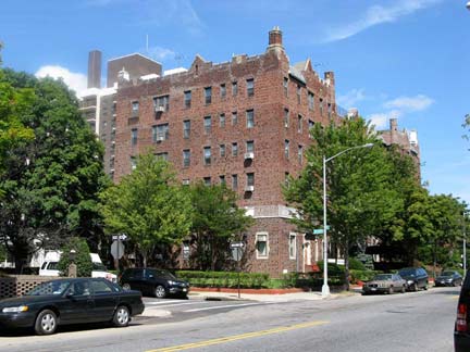
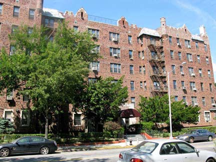
Avenue I and East 5th Street, from the golden age of multifamily dwelling design, likely 1910-1925, give or take a year or so. Regular FNY readers know I rail against the modern method of quick and dirty apartment house construction, with concrete lawns, conspicuous meters, rusting fire escapes and Fedders air conditioners. This building dates from the days when apartment living was actually thought of as preferable. When this place was built, you walked, or the trolley took you, to the nearest el and you were whisked to the office or counting-house with surprising alacrity. Somehow, you made do without air conditioning in your apartment or the train; you wore a suit complete with jacket, tie and hat, or if you were female, a coat, dress, slip, girdle, stockings, high heels, no matter how hot it was. I’m not advocating a return to the days when dressing for comfort wasn’t the norm, but I do advocate a return to the days when majestic architecture like this was constructed for renters, and you didn’t pay an arm and a leg every month.
Brooklyn has both and Avenue I and an Avenue J (go figure — Avenue E was replaced by Foster Avenue sometime in the distant mists) … it was laid out in the late 1800s, unlike Washington, DC, which Pierre L’Enfant designed in the late 1700s, a time when there wasn’t yet a clear division between I and J (they were thought of as two representations of the same letter at that time) and so, there’s no such thing as J Street in DC– after I Street, you pass go straight on to K Street.
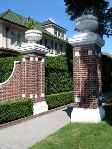
The “gateway” to Midwood is here at Avenue J and Ocean Parkway. As a rule, ‘gateposts’ like this signify an originally private development, and while the ones north of here are readily identifiable (Ditmas Park, Prospect Park South, Fiske Terrace, etc) whatever the development here was has been lost to posterity.
Historian Joseph Ditta: The “forgotten” development was called “Manhattan Terrace.” At N-YHS we’ve got a circa 1902 booklet put out by the Manhattan Terrace Improvement Company that calls Avenue J “Jarvis Road,” though I don’t believe that name was ever official.
When I stumbled past Avenue J and Coney Island Avenue in the summer of 2008, Washington Mutual, which featured some of the most obnoxious TV commercials I’ve ever seen with bankers penned up like hogs in the bank basement, was still a going concern. They went under the next year and were acquired by Chase. The Dime Savings Bank of Brooklyn constructed this Moderne classic likely during the 1930s.
A great sight, a magnificent building, where your money is safe (as safe as possible these days, I suppose), flag whipping in the breeze…
A couple of doors north of the bank is a magnificent synagogue, at least on the exterior, Congregation Talmud Torah Of Flatbush. Between the bank and the temple is a taxpayer building with a mysterious, inscrutable black-panelled exterior. This sort of thing usually conceals a social club of some stripe.
Skipping a few blocks now, to the other main Midwood shopping strip, Avenue M, which was bruited through the heart of South Greenfield generations ago. At the NE corner of M and East 19th is M & M Pharmacy, with its incredible neon sign that hangs out over the sidewalk. On this day only the leeward side was lit up, in red and green. I’d imagine the neon still works on the awning signs, too — I’ll have to cruise past one night. I’d make this my neighborhood phamacy on the neon alone (I’m still glad I use an indie drugstore in lovable Little Neck and not a Walgreens or Rite Aid).
This was a fairly large Child’s Restaurant, taking up all of the north side of Avenue M between East 18th and 19th. I’d imagine Child’s built the block, occupied one of the storefronts, and rented the rest. Entwined seahorses always mark a Child’s, whose remains can be found scattered throughout the Five Boroughs.
Coney Island Avenue and Avenue M make a triangle with Chestnut Avenue, one of South Greenfield’s original roads. That is one mighty piece of crapitecture on CI Ave. just south of Chestnut, though it may have its fans — it’s certainly formidable. On the NE corner of Avenue M and CI Ave is the stolid, sensible Midwood Memorial Chapel, most likely established by Harry Nieburg and Sons. It must take a certain temperament to establish and own a funeral home; the acclaimed HBO series Six Feet Under explored the foibles of one such family. In the traffic triangle, in 2008, I shot the future Bermuda Restaurant — some of the palms were already in place.
On East 4th between Avenue L and M is a lamppost I’ve admired for decades — it still has the shell of an old Westinghouse AK-10 “cuplight” which formerly illuminated Friends Field. Much stronger lightbulbs have been installed on the post recently.
Friends Field is a very large athletic field and playground south of Washington Cemetery (est. about 1855), East 4th, and McDonald Avenue. It was built in 1921 by the Quakers (Society of Friends) to provide athletic fields for Brooklyn’s Quaker schools. The Friends sold the field to NYC in 1973 and it operates as a public park today. Erasmus Hall High School uses the grounds as a home field. Page completed March 31, 2010.
Page completed 3/31/10


