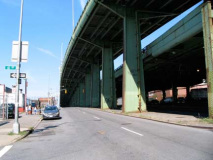
After a re-examination of Bay Ridge’s 3rd Avenue in Bay Ridge in Part One, I continued along 3rd Avenue in its mid-section, under the elevated Gowanus Expressway in Sunset Park from 65th Street north to the Prospect Expressway, where some of 3rd Avenue seamlessly becomes Hamilton Avenue and the rest continues along to downtown Brooklyn. I’m following the path of the recently (June 2010) eliminated B37 bus, which traveled the entire length of the avenue. Budget cuts have forced its doom and now two bus routes, the B70 and B103, take up the slack. Neither of those routes travel 3rd Avenue in Sunset Park, where the two most heavily traveled-to destinations are the Bush Terminal industrial park and Lutheran Hospital, 2nd Avenue and 55th Street. Admittedly, this was the part of the route where I fell asleep the most while riding the B37. However let’s press on and see if there’s anything interesting at all on 3rd Avenue under the expressway…
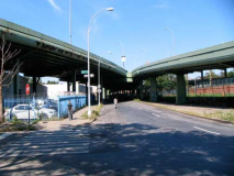
At 63rd Street and 3rd Avenue are two older pieces of roadway infrastucture, as both of the roadways shown were part of the 1940 Circumferential (Belt) Parkway. The elevated viaduct at left becomes Shore Parkway and runs south, southeast and east before connecting with Laurelton Parkway (which branches into Cross Island and Southern State Parkways) and Sunrise Highway in Laurelton, Queens. Those roads are closed to bus and truck traffic as their overpasses are too low to accommodate anything but cars and motorcycles. On the right side of the photo is a ramp from 3rd Avenue and 65th Street. Above right: the massive Gowanus Expressway was bruited through in the early 1960s as the connector to the Verrazano-Narrows Bridge.
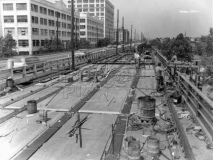
In the older photo workers assemble the new Gowanus Expressway in the early 1960s. Its predecessor, Gowanus Parkway, had necessitated the demolition of every building on the east side of 3rd Avenue in the early 1940s. photo: brooklynpix
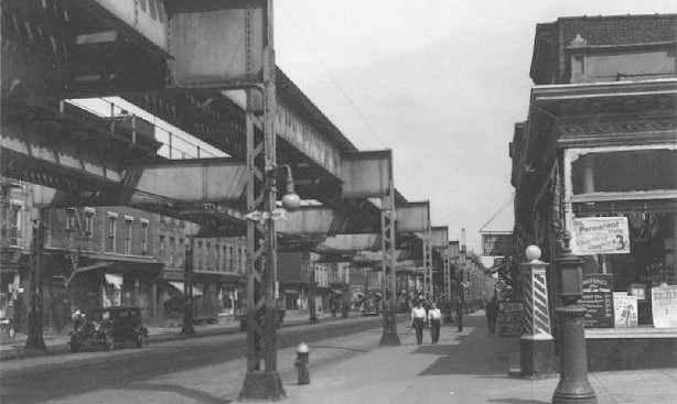
Third Avenue from 38th Street south to 63rd Street has seen little sun beginning in 1893 (when it was still part of the town of New Utrecht) and the present, as it has always been under an overpass servicing first an elevated train and then an elevated expressway — and for good measure, the cover was extended north in 1940 from 38th Street to 18th as the Gowanus Parkway, later Expressway, took shape.
Third Avenue El at 45th Street in the 1930s. Note the barber pole at right, the “ice cream cone” FDNY alarm, along with the indicator light mounted on an el pillar, and the old school One Way sign. While some of the buildings on the west side of the street (at left) are still standing, every building on the right side has been torn down, giving 3rd Avenue something of an unfinished look to this day. After the el ceased operations in 1940, NYC roads czar Robert Moses, in an unusual arrangement, employed the el pillars to mount an elevated roadway, the Gowanus Parkway, between 38th Street and the Belt Parkway ramp, and built a new structure over 3rd Avenue from 38th north to Hamilton Avenue. photo: Mellow One
Although Moses could have built the Gowanus Parkway over less-trafficked 2nd Avenue, a block to the west, he proclaimed 3rd Avenue to be “blighted” much as Forest City Ratner proclaimed the blocks to be demolished for the Atlantic Yards project “blighted.” In reality this was not a blighted area at all:
The heart of the neighborhood — the focal point that gave it unity and a sense of community — was Third Avenue. Lining it, along with newsstands off which 9,000 Nordisk Tidendes were sold every day, were seven movie theatres, dozens of tiny restaurants run by couples and featuring recipes from the old countries … and scores of small, friendly “Mama and Papa” stores (the Northland Gift shop, the Finnish Book store, a hardware store that looked like a general store out of the Old west, a butcher shop that raffled off twenty-five big turkeys every Christmas) that occupied the ground floor of three- and four-story brickfronts in which Mama and Papa lived upstairs with the children…
3rd Avenue and 53rd Street in the 1910s. photo: Mellow One
The El had cast a shadow over Third Avenue, but the El had been forty feet wide. The Gowanus was ninety-four feet wide. Its shadow was more than twice as broad.
And more than twice as dark. The gaps between railroad ties had made the el’s shadow a Venetian-blind shadow; sunlight had come through as if through the slats of an open blind. A highway was a concrete slab, without gaps. The construction of the Gowanus Parkway, laying a concrete slab on top of lively, bustling 3rd Avenue, buried the avenue in shadow, and when the parkway was completed, the avenue was cast forever into darkness and gloom, and its bustle and life were forever gone. from The Power Broker, Robert Caro, Knopf 1974
After 1940, Third Avenue in Sunset Park became a ghost roadway, as there was no El to bring people to its shops and the dark roadway overhead breeded desolation and crime. Most of the shops and restaurants closed or relocated, and criminals and gangs moved in to take the place of the residents who were moving out. Crime is reduced, as it was in most of the city in the late 20th Century, but Third Avenue has never really joined the renaissance that its brother avenues 4th and 5th have had both in Sunset Park and Park Slope. 3rd Avenue is what it is.
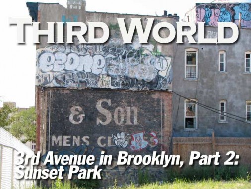
A recent teardown at 3rd Avenue and 60th Street has revealed a partial remnant of a ‘wall dog’ painted ad for ???? & Son Men’s Clothes. Are there any more of these around town? Who is the haberdasher? (Fun word to say, like “knickerbocker’)
I have always had an attraction for old brick factories or warehouses — I live in an apartment complex that sort of looks like this building taking up the entire block between 58th and 59th Streets and 2nd and 3rd Avenues. It was likely a carbarn for the Brooklyn City Railroad, and the date it was built is inscribed on the 2nd Avenue side.
The Brooklyn City Railroad (BCRR) was the oldest and one of the largest operators of streetcars (horsecars and later trolleys) in the City of Brooklyn, New York, continuing in that role when Brooklyn became a borough of New York City in 1898.
The BCRR was incorporated on December 17, 1853 with capital of $2,500,000, a large sum in those days. Its first line, the Myrtle Avenue Line, was the first horsecar line in Brooklyn, and opened on July 3, 1854. The line operated from Fulton Ferry via Fulton Street and Myrtle Avenue to the former stagecoach stables at Marcy Avenue.
Ultimately, through a series of mergers and acquisitions beginning in 1893, the BCRR became Brooklyn Rapid Transit, the precursor to the BMT –Brooklyn Manhattan Transit–subway line. When the BRT was dissolved following the Malbone Street Wreck, however, the Brooklyn City didn’t become part of the BMT and remained separate, joining Brooklyn-Queens Transit in 1929, which survived until NYC consolidated all its transit lines in 1940.
The building in question was likely a carbarn (or stables) for either the 3rd Avenue Line (running from Fulton Ferry to Fort Hamilton), or the 2nd Avenue Line (from Sunset Park to Gravesend). wikipedia
Throughout the Gowanus Expressway (né Parkway) existence companies have used the buildings along 3rd Avenue as billboards; a Japanese restaurant ad can be seen here.
For many years, Precise Products had mounted a micrometer on a building facing the southbound roadway.
Walking down 58th Street to get a shot of the BCRR barn, I noticed a number of stooped brick buildings, soome of which have their original wrought iron railings intact.
I detoured onto 2nd Avenue for a few blocks from 58th to 50th Streets, since there are some interesting items along the way, such as this turreted apartment building at 56th Street. 2nd Avenue and its brother, 1st, have no residential buildings at all, except this one. The playground and the hospital across the street are named for Martin Luther (1483-1546), the founder of Protestantism.
Lutheran Medical Center was founded in 1883 by a Norwegian Lutheran Deaconess-Nurse, Sister Elizabeth Fedde, to serve the Norwegian immigrant community. The institution has provided care for the southwest Brooklyn communities for more than 80 years.
2nd Avenue is an odd stretch — there’s some massive warehouses from the 1930s and 1940s, some scattered lunch counters for weekday workers, some long-ago grocery stores, and what was once a stable boarding and feeding horses, if you accept that these signs are vintage at 2nd Avenue and 52nd Street. I’m not quite convinced, as the “Livery, Sale and Feed” sign is painted on a corrugated metal gate, and the painted “stable” sign looks a bit pristine for something that’s supposed to be around a century old. I’ve been fooled before by movie set dressing that remained in place after the production vacated the area. Is that what we’re looking at here?
ForgottenFan Dan Casey: I’ve spotted the “livery, stable and feed” signage you correctly identified as movie dressing in part 2 of your 3rd Avenue page. It shows up quite clearly at about 4:00 into episode 3 of Boardwalk Empire. Filmed on huge Greenpoint sets, and featuring a lot of outer-borough exterior shots nicely blended with CGI backgrounds, the show will surely give a similar treatment to other old Brooklyn and Queens locations when filming for the second season starts up.
Back to 3rd Avenue we go — I’ll stick to the west end of the street, since the east end was shaved off for the Gowanus Parkway construction and is thoroughly nondescript. At 50th Street is what looks like Arcoiris Nightclub, a candy wholesaler at 48th, as well as A.L. B. Industrial Supplies and steam Specialties, to which I was attratced by the plastic lettering.
You know, when the big one finally hits, these places will survive.
These campaigners were here for the elevated train days, and they’re here for the elevated expressway. I like the quality of persistence. They’re waiting for the time when they see open sky — will it ever come?
Third Blesser coffee shop. When I saw this awning I immediately thought of the Third Bardo, the 1960s rock group, and Joe Besser, the Forgotten Stooge. I’d like to know the story behind this moniker.
Industry filled the void after shopkeepers and residents fled Third Avenue. Many businesses serve the Cross Harbor Railroad and the industries along 1st and 2nd Avenues — piers, factories, warehouses and railroad sidings. There are still a few bars and strip clubs along 2nd Avenue, or were till recently.
Frankel’s is one of the survivors of the pre-Gowanus Expressway days on 3rd Avenue. Now on the NW corner of 3rd and 40th Street, it had to move across the street when the east side of the avenue was torn down. Adolph Frankel opened the store in 1890 selling clothes and sundries to longshoremen and over the years, evolved into a shoes and boots store, selling all the popular makes from Frye to Adidas. The store is still run (2010) by Adolph’s grandson Marty Frankel.
39th Street looking east toward 3rd Avenue just after the Gowanus Parkway opened. As you can see trolleys were still plying 39th Street. Two lines used 39th Street, #8 along 39th Street and Church Avenue to Brownsville, and the #30 along 8th Avenue in Sunset Park. The #8 was almong the longest-lived trolley routes in Brooklyn, finally succumbing on Halloween 1956. The city and borough have periodically talked about reviving light rail, and in 2010 yet another proposal was floated. I don’t think much will come of it. Above image: brooklynpix.com
The building on the right, housing Haddon Hall Cigars on the ground floor, is still there, but its conical tower is now missing and now holds a cell phone routing tower.
Here’s a pair of views of the el curve at 3rd Avenue and 38th Street. The el traveled over 38th Street to 5th Avenue, where it turned north and ran along Green-Wood Cemetery, finally joining other downtown el lines that traveled over the Brooklyn Bridge to Manhattan. The el was torn down in 1940 and its right of way is now occupied by an on-ramp to the Gowanus Expressway from 4th Avenue. The Ace Diner seen in the 1st photo was close to the location of the colonial-era DeHart-Bergen House, constructed in 1671 and demolished early in the 20th Century.
Note the three houses mid-block on 38th Street in the 1st photo. They’re still there, though heavily re-sided, as this Google Earth image attests. Note 3rd Avenue is much closer to these houses, as much of the east side of the avenue was torn down in around 1940 to make way for the Gowanus Parkway. 1930s images: Mellow One
A set of railroad tracks cross 3rd Avenue at 38th Street, near the large Costco supermarket. These tracks are still officially active, though a cleanup would have to be made before a train could run on them. The tracks connect the old South Brooklyn Railway and BMT subway tracks using the MTA West End line (D train), which formerly employed tracks on McDonald Avenue to deliver freight to the Coney Island Yards. Freight traffic is now usually carried by the West End line itself.
Chased out of midtown, porn purveyors now make do on the fringes, like here on 37th and 3rd. There will always be a market for porn, from nickeloldeons to trenchcoat-brigade movie theatres, to VHS tapes, to the internet, to …
A look at the Gowanus Expressway in pedal to the metal glory (except when traffic jams turn it into a parking lot). Robert Moses was proud of what he made 3rd Avenue, but no one else has much of a good word for it — it’s like a trip to the dentist, necessary yet unpleasant. Various schemes have been batted about regarding placing the whole shebang in a tunnel, like Boston’s Big Dig, and while the Big Dig left much of Boston’s downtown much more accessible and in the open air, finally — the operation was mobbed-up and billions of dollars more expensive than first quoted. So, it won’t be done here and until we all switch to hovercrafts, the Gowanus Expressway will be a Sunset Park landmark. These massive pylons were erected in the early 1960s so the Expressway could withstand the extra Narrows Bridge bound traffic.
A look at 3rd Avenue and 36th Street in 1923 when the Gowanus Parkway was a gleam in Moses’ eye. Once again, everything on the right side of the picture had disappeared by 1940, but much of the left side is still there, especially the massive Bush Terminal buildings. The Terminal was founded by Irving T. Bush in 1900 to compete with Manhattan’s dock works, and it eventually grew into an industrial “city within a city.”
These white-painted monoliths on Third Avenue between 29th and 36th Streets were constructed by architect William Higginson in the first 3 decades of the 20th Century. There are 15 lofts in total, each 6 to 8 stories in height, fully 200 acres of land given to vast warehouses and manufacturing lofts. Bush Terminal had a waterfront railroad and 18 deep water piers.
Today Bush Terminal is being converted by Industry City Associates into a home for broadband services providers, paving the way for digital broadcasts on the internet, as well as light manufacturing and artists’ lofts.
Desolation
32nd Street between 2nd and 3rd Avenue is not postapocalyptic (not yet anyway) but on weekends, when no one is working here, it can get desolate indeed. Side streets in Bush Terminal are still paved with Belgian blocks, and remnants of Cross Harbor Railroad tracks that shuttled shipments from building to building can still be seen though they are partially paved over. The whole block reeked from the contents of two garbage trucks.
2nd Avenue
On 2nd Avenue, fire alarms are no match for big rigs. The avenue here has its own quality of abandoned grandeur, as it froms the back edge of Bush Terminal and formerly faced a large dockworks organization. Its Cross Harbor Railroad tracks are gradually being paved over.
The scene would be incomplete without a jail. And here’s a relatively new one, on 29th Street between 2nd and 3rd. Even if some one did bust out, there’s nowhere to go! This Metropolitan Detention Center was built in the 1990s to hold prisoners awaiting Federal trials. Notable prisoners have included John Gotti Jr., his uncle Peter Gotti and Reverend Al Sharpton.
Conveniently enough, with a prison around the corner, here is a uniform wholesaler.
As Gowanus Bay bends toward the shoreline, 2nd Avenue is truncated and the cross streets come to dead ends. 27th Street, right, ends at a power plant; others end with views of dry docks in which ships are being refitted.
After passing the junkyard between 27th and 26th my nostrils detected a familiar stench. Not the expected sewage treatment plant, but the smell of chickenshit and chicken entrails.
We passed a candy wholesaler on 48th Street. Here’s some more for passing motorists on the elevated expressway.
I was mildly surprised to stumble on Rossman Farms at 3rd and 26th, a florist and vegetable and fruit shop. (Since I have unfamiliar vegetables only at gunpoint, what are those things on the right?) Competition comes from C Town, 25th Street and 4th Avenue, and Fairway, Van Brunt and Reed streets in Red Hook. Seen mostly raves about Rossman, but also saw some things about “rats the size of cats.” With that chicken slaughterhouse across the street, not a surprise.
Butternut squash, apparently.
3rd Avenue’s Mystery Building
This building front between 25th and 26th Streets has always intrigued me. The metalwork reminds me of swaying crinoids or various other seafood, though this is not an ex-Childs Restaurant. A former firehouse, perhaps? Definitely goes back to the 1890s and the very early days of 3rd Avenue.
At the end of 25th Street we spot the towers of a cement plant, and from 24th, a familiar Lady raises her torch. We are looking across to Red Hook’s new IKEA campus; the gantry cranes have been preserved in the parking lot as decorative elements!
As it passes Jetro Cash and Carry (a wholesale food market, competing with Costco 20 blocks away) the west side of 3rd Avenue seamlessly becomes Hamilton Avenue, which we’ll explore on a future page.
We will travel 3rd Avenue’s final leg to downtown Brooklyn at the edge of Fort Greene on the next installment…
