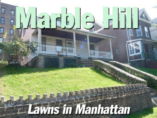
Lawns in Manhattan? Homes with porches? That only happens, as a rule, in Marble Hill, the only section of Manhattan located on mainland USA — because of a massive engineering project that was finished nearly a century ago. Even though Marble Hill is politically affiliated with Manhattan, geographically and “spiritually” it’s Bronx all the way, as we’ll see.
Here’s an 1885 map of northern Manhattan and the Bronx, when the Harlem River flowed into the Hudson via the twisting, turning Spuyten Duyvil Creek, a notoriously difficult waterway to cross. On the Manhattan side, a lot of “paper streets” or streets planned but not yet built, are shown. The only route in northern Manhattan at the time was Kingsbridge Road, which was renamed Broadway sometime in the early 20th Century.
At the time there were two methods of passage across the waterway: Kings Bridge, to the north, and Fordham Bridge, where today’s West 225th Street and the Bronx’ West Kingsbridge Road are located.
Frederick Philipse built the first Kings Bridge, a tolled span over Spuyten Duyvil Creek, in 1693. Benjamin Palmer and Jacob Dyckman built Farmer’s Bridge in 1759 to avoid paying the high tolls charged by Philipse. During his retreat from the Battle of Harlem Heights in 1776, General George Washington and his company used both the King’s Bridge and Palmer and Dyckman’s free bridge to escape to White Plains.
By the late 19th Century, when the difficult conditions of the Hell Gate (where the Harlem and east Rivers meet) had been alleviated, and there was a need for ship traffic to be able to easily enter the Hudson, and thence the Erie Canal, Great Lakes and western United States. Therefore, Spuyten Duyvil Creek was straightened and dredged deeper to allow larger ships to use it.
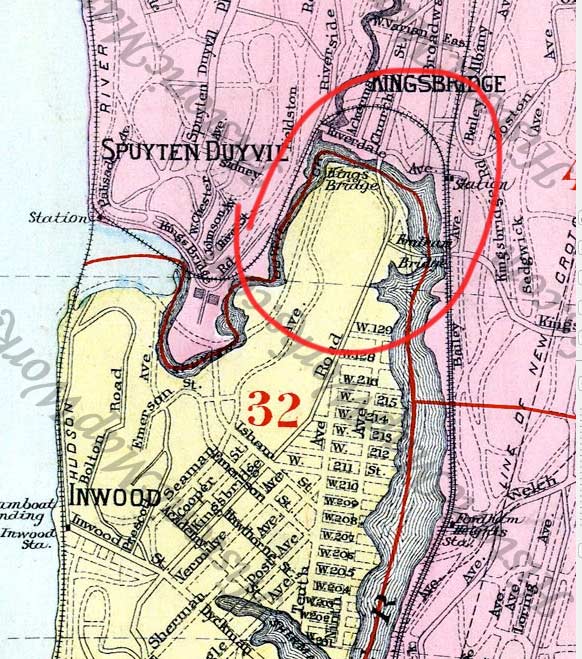
After the newly christened Harlem River Ship Canal was completed, an island was left over between the canal and the remaining section of Spuyten Duyvil Creek. The section remained an island from 1895 to 1914, after which the old creek was landfilled, joining what was once the northern end of Manhattan to the mainland. This Interborough Rapid Transit map from 1908 shows the temporary island.
The name of Marble Hill was conceived by Darius C. Crosby in 1891 from the local deposits of dolomite marble, which is a relatively soft rock that overlay the Inwood and Marble Hill communities. The marble was quarried for the Federal buildings in lower Manhattan when New York was the Capital of the United States in the 1780s. Washington Heights and Inwood Online
Crosby (1832-1897) was a real-estate lawyer and community leader.
By the Roaring Twenties, Marble Hill had acquired its present appearance, with a street layout and beginning house construction. This 1949 Hagstrom is just about accurate today for Marble Hill with the exception of Leyden Street, which was absorbed into the property of Promenade Apartments.
The Marble Hill Metro North (formerly NY Central) station is shown east of Broadway, so that’s either an error or the station was later moved to its present location west of Broadway.
Entering Marble Hill
I took the IRT #1 train, which is undergoing a lot of repair work and was closed southbound (to get home I walked to the Jerome Avenue #4 train) at 225th Street, the northermost Manhattan stop on the #1 7th Avenue/Broadway line.
To see the Harlem River today it’s hard to believe it wasn’t in this position at all until the late 1890s. Looking south toward Kingsbridge Heights (left) and Inwood (right).
The el staircase is just north of Broadway Bridge, a mechanical lift span built in 1962, a product of complicated engineering that can elevate both the Broadway roadway and the elevated line high above the Harlem River to allow shipping through. In effect, it fulfills the same function the original Kings Bridge did when it was first built by Fredrick Philipse in 1693. The first Broadway Bridge, built to span the Ship Canal in 1895, is now the University Heights Bridge (spanning the Harlem between East 207th and Fordham Road) in modified form, after it was floated into position in 1908.
The Marble Hill Metero-North station is one in a series of stations serving both the commuter line and Amtrak trains on the eastern shores of the Hudson River. A high cliff separates it from the remainder of Marble Hill. Joint Amtrak and Metro-North service runs on the tracks just west of this station.
This Deco-area apartment building, with classic corner casement windows, is on West 225th Street (Henry Rivera Place) opposite the station. Rivera was a local Marble Hiller killed attempting to prevent a robbery in 1995. West 225th was formerly called Muscoota Street, a Native American term meaning “river along the geen sedge (marsh plants)” meaning the Harlem.
A pair of homes along Marble Hill Avenue. Many freestanding houses have peaks and cupolas, but nearly all have been homogenized by the addition of aluminum siding.
The shortest street in the neighborhood is Marble Hill Lane, a set of steps squeezed between apartment buildings from Marble Hill Avenue and West 228th. It resembles neighboring Inwood in its urbanity.
This illustration shows Phillipse’s Kings Bridge, built 1693, as it appeared in the colonial era.
Marble Hill Avenue north of West 228th. Kings Bridge, or one of its successors, is still located under the street surface, as it was not removed when the original creek was landfilled here in 1914. The name of the street changes midblock to Kingsbridge Avenue at the Bronx-Manhattan borough line.
The oldest building remaining in Marble Hill is likely St. Stephen’s Methodist Episcopal Church, which as the cornerstone says, was built in 1897 (Alexander McMillan Welch). The congregation dates to 1826 in what would be the Mosholu Parkway area, moving to Riverdale in 1876.
[T]he historic Shingle-style building features a tall bell tower at the corner and tall gables terminating in broad pediments that frame circular stained glass windows on both street facades. The interior is based on the “Akron Plan,” a popular style of Protestant church architecture in the nineteenth-century that provided increased capacity and encouraged participation when adjacent Sunday school classrooms were opened into the auditorium. At St. Stephen’s, the Sunday school classrooms on the second floor balcony are divided by rolling partitions that can open into the amphitheatre-style auditorium below. Above the curved oak pews is an extraordinary wood ceiling paneled in a herringbone design. American Guild of Organists
The longtime pastor (1946-1977) of St. Stephen’s, Dr. William A. Tieck, was also a Bronx historian and founder of the Kingsbridge Historical Society. He wrote several historical books about the Bronx, including Riverdale, Kingsbridge Spuyten Duyvil New York City, A Historical Epitome of the Northwest Bronx. He preceded Lloyd Ultan as the official Bronx County Historian.
A freestanding peaked beauty at the corner of Adrian Avenue and West 228th. Many Marble Hill streets were named for Dutch settlers in the colonial era; Adriaen Van Der Donck, New Amsterdam’s first lawyer, was granted permision to buy land from Native American tribes in 1646. The tract included hundreds of acres along the Hudson from Spuyten Duyvil to Yonkers, the city Van Der Donck is credited with founding. His nickname, Jonckheer (“young squire”), was bowdlerized by the British who took over later as “Yonkers.”
Van Corlear Place may be the most untypical street in Manhattan, as it curves gently twice and features freestanding homes as well as a couple of attached brick buildings.
Van Corlear was the official messenger sent by Governor-General Peter Stuyvesant to get reinforcements from the mainland when Nieuw Amsterdam was attacked by the British Fleet. According to legend and mentioned in Father Knickerbocker’s History of New York by Washington Irving, van Corlear was drowned when he crossed the creek and was pulled down by a giant mossbunker. In reality he waded across the Spuyten Duyvil Creek. Washington Heights and Inwood Online
Occasional guides show this as Corlear Place, but the street signs included the Van.
Van Corlear and Jacobus Places come together at a slight rise. Catercorner are a large brick apartment house and a pair of eclectic private houses. The “Jacobus” is Jacobus Dyckman, who ran the Dyckman Tavern in the area in the late 1790s and assisted in sponsoring the Farmers Bridge, the free route across the Harlem River. Other sources have it as honoring Jacobus Van Cortlandt, a two-time NYC mayor (1710-11, 1719-20). Or, perhaps, it was David Schenk Jacobus, a professor of engineering at Stevens Tech across the river in New Jersey in the 1860s.
The Promenade Apartments dominate the west end of West 225th Stret. The bedrock is deep in this part of town and high rise apartment buildings dot southern Spuyten Duyvil.
The corner of West 225th and Adrian Avenue is decidedly Bronx-like, as gently curved corner buildings like this are scattered all over the borough.
Teunissen Place, a dead end off Terrace View Avenue, is named for the first settler in what became Marble Hill; Tobias Teunissen, a wool washer and farm hand who had previously been a night watchman in Leyden, Holland, in the 1630s. He was killed in 1655 by the Weekwaeskeek Indians in a raid, though his wife and 4 children were later ransomed from the tribe.
104 Terrace View Avenue, an early apartment building with stained glass and terra cotta ornamentation, overlooks a valley into Spuyten Duyvil.
John F. Kennedy High School, 99 Terrace View Avenue, opened in 1972 (hence the bland architecture) was once called one of the most dangerous high schools in the city, but conditions have improved since a student was murdered on campus. Sports teams are nicknamed the Knights of the Red Flaming Torch. In his youth, President Kennedy resided for a couple of years with his family in Riverdale, a couple of miles to the north.
Freestanding, porched homes with lawns, Terrace View Avenue, Manhattan.
This house was undoubtedly altered greatly from when it was built, with a ground floor garage, enclosed porch and siding. Terrace View Avenue near curve to West 228th Street.
West 228th near Adrian. Just as Marble Hill resembles the Bronx more than Manhattan, it’s subject to creeping Fedderzation, unlike the island portion of New York County.
This contrast can be found frequently in the Bronx, the Borough of Apartment Houses, adjoining two-family homes from earlier in the 20th Century.
We have crossed the borough line into the Bronx. This boxy building at Kingsbridge Avenue and West 230th labeled Telephone Building is one of several scattered around town, always plain jane brick buildings with quoins and window lintels, but otherwise no nonsense architecture.
Just as Marble Hill was temporarily an island, so West 230th was at the southern end of a former island, Hummock Island, occupied by colonial settler Alexander Macomb. The island was eliminated by landfill after 1916. At the west end of the street, the city’s longest step street extends 4 blocks from Riverdale to Netherland Avenue.
The Roman Catholic St. John’s parish was established in 1877; the handsome Tudor-style church building with its distinctive zig zag patterned spire was built from 1904-1910.
Next door to St. John’s, at Kingsbridge and West 231st, is the Bronx Mediator Church, established in Yonkers in 1855, with the present brick building completed in 1914 by architect Henry Vaughn, who also designed the National Cathedral in Washington, DC (which took over 80 years to complete). The church features Tiffany windows in its chapel.
The West 231st Street station at Broadway has recently seen its Swiss chalet-style station house repaired and repainted, though ongoing work was still being done in September 2011.
Couldn’t exit this part of town without paying tribute to this classic 1915-era Bishop Crook Type 24a, Broadway near West 230th.
10/29/11


