

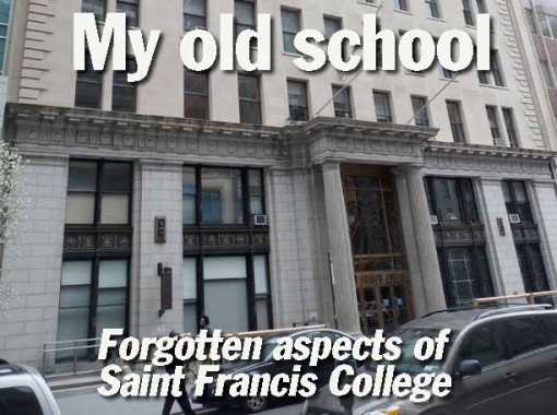
I don’t believe I have ever mentioned my college previously on Forgotten New York during the 13 years since 1999 that I have been producing this, your website chronicling the ‘infrastructure of a lost metropolis.’ Between 1975-1980 I attended St. Francis College, which is now pretty much a business school, but in that era was more of a liberal arts college. Then as now, the school is at 180 Remsen Street between Court and Clinton Streets in Brooklyn Heights. I graduated with a BA in Sociology, but I wasn’t the greatest student in college. I studied enough to pass the tests and eventually get a degree but by the time I was in “13th through 16th grade” the work was fairly over my head. It also helps, when you’re in college, to have some idea what you want to do with your life, and I didn’t figure that out until age 40 (I would rather have been a NY historian and FNY is an outgrowth of that). The skills that saw me through several decades after school were acquired in the school newspaper office, where I began to write and learned several specifics of the printing trade, and I have worked with words ever since.
St. Francis is in Brooklyn Heights, which contains some of the crown jewels of Brooklyn and NYC architecture. The Super 70s, though, were a long time before I started looking around NYC’s nooks and crannies for hidden gems. Sorry to say, I didn’t go on very many spelunking expeditions during lunch hour. There were a few spots that I did frequent, which will be shown here on this page. After I graduated, I had a girlfriend still attending SFC and in 1982, she gave me a book for my birthday: Clay Lancaster’s “Old Brooklyn Heights: Brooklyn’s First Suburb”, first written in the early 60s and considered a major work of its genre. So, by 1982, things were beginning to coalesce a bit and I was beginning to show interest in chronicling the city in which I live. It would still be a good 16 years, and the popularization of the internet, before I began to do anything about it.
Pardon me if you’re using a slower connection and these photos take time to draw in. By mistake, I saved them in Photoshop at too high quality.


When you exit the school by the front door and head east toward Court Street you are rewarded with a side view of Brooklyn Borough Hall.

St. Francis College was founded as St. Francis Academy, a school for Irish immigrant boys, in 1859 at the direction of Bishop John Loughlin (for whom Rudy Giuliani’s high school, Bishop Loughlin in Fort Greene is named). The first school was located on Baltic Street in Cobble Hill. It became a college in the early 1880s, while continuing as a secondary school; the two were sundered in 1902 and today’s St. Francis Prep, which moved to Williamsburg in 1953 and then Fresh Meadows in 1974, is a completely different entity from the College.
In 1960 the College began to purchase buildings belonging to Brooklyn Union Gas (the descendant of which is National Grid as of 2012) and also to tear down older structures and construct new facilities, such as this one in 1968. When I attended SFC, we referred to the ‘old building’ and the ‘new building’ of which this was the latter.


This, the ‘old building’, was built in 1914 [Frank Freeman, arch.] as the headquarters of Brooklyn Union Gas. The front entrance on this building leads to the College’s chapel; the new building has served as the front entrance since it was finished in 1968. St. Francis purchased this building in 1962 and it served as the main school for six years.

The Frank and Mary Macchiarola Academic Center was constructed in 2005, replacing the venerable 1857 Brooklyn Gas Light Company Headquarters, which would have likely been landmarked had it survived until recently. The building had served as SFC’s McGarry Library until demolition.
Borough Hall Skyscraper District [LPC]
Arthur Benson, of the Brooklyn (specifically the town of New Utrecht) family for whom Bensonhurst is named, founded the Brooklyn Gas Light Company in 1823. Dr. Frank Macchiarola (1941- ), a 1962 SFC graduate, was NYC Schools Chancellor from 1978-1983, and served as President of St. Francis from 1996-2008; he then became the school’s Chancellor, and a Professor of Philosophy, before his death in 2012.
The Two New Yorks [Frank Macchiarola, City Journal, 1993]

Though the Brooklyn Gas Light Company HQ did not survive, the adjoining Romanesque-Queen Anne Franklin Building [Parfitt Bros. 1887] is still there, albeit in tough shape. The Parfitts also designed the Grosvenor and Berkeley Apartments on Montague Street (see below).

NW corner, Court and Montague Streets. The subway entrance on the corner gives access to the IRT 2, 3, 4, 5 as well as the BMT R and sometimes N, as the lines are all connected via underground passages. It’s among the most intricate underground complexes in the City. I used it every morning to journey to Remsen Street, though late at night it was closed and I used a somewhat more forbidding entrance (see below).
16 Court, one of Brooklyn’s skyscrapers, is described in the Landmarks Preservation Commission report linked above.
If I had just afternoon classes, I would sometimes take the B63 (5th Avenue) or B37 (3rd Avenue) buses, which stopped in the area. The B37 has been sacrificed on the altar of budget cuts.

View of Remsen Street from the large open plaza in front of Brooklyn Borough Hall. The College can be seen in the distance on the left. I have had to enter the corner building, #32 Court [1916, Starrett and Van Vleck] more often than I’d like in recent years, as my oral surgeon has his office there. There are fine views of the waterfront and Manhattan available from the upper floors.

O’Keefe’s Bar and Grill, which was the default bar for St. Francis students, Court between Remsen and Livingston. In 1978, I watched the Yankees defeat the Red Sox 5-4 in the ‘play-in’ game after the two teams had tied at the end of the regular season. I spent more time in here than I should have.

Court and Schermerhorn Streets. Now the home of a somewhat upscale Chase branch, I had a job on the ground floor here in a passport photo studio in 1978, developing pictures and sweeping the floor. Through most of the 20th century, Court Street, its parallel streets and the area south of Brooklyn Heights had a working class atmosphere. All that changed in the late 1980s when new money began to infuse the neighborhood.

On the opposite side of Court, the bagel store used to be home to Nick and Joe’s Pizza. I did not often eat out when attending SFC, contenting myself with the cafeteria offerings or a brown bag lunch. There were numerous opportunities for affordable dining in the neighborhood.
Note the Chase branch — it’s just across the street from the larger one in the above photo. Next door, the Queen Restaurant was there during my SFC years.

Packer Collegiate Institute, 170 Joralemon Street, could be seen from the rear of the SFC cafeteria. It goes all the way back to 1853, when construction began on a design by the prolific Minard Lafever. In “Brooklyn: an Architectural Guide” Francis Morrone calls it Tudor Gothic. The building combines elements of ecclesiastical architecture (ogee-curved windows on the chapel) with castle-like turreting. Packer was an all-girls’ private school until it became co-ed in 1972. St. Francis College first admitted women (other than nuns) in 1969.

North side of Remsen Street, across from the College. Many of these buildings had restaurants frequented by SFC students and faculty, as well as attorneys from the nearby courts. I remember a German restaurant called Woehrle’s Woerner’s and Callahan’s, a bar/restaurant a bit further north in class from O’Keefe’s.

99 Clinton, a former Gothic church at the corner of Clinton and adjacent to the College at 180 Remsen, now features pricey, albeit dark, apartments that sell for more than $2 million.


It started out, though, in the mid-1800s as the First Presbyterian Church, later (1882) the Second Presbyterian and then Spencer Memorial. The church disbanded in 1994 and the building was converted to residences. On the left side of the picture, you can see a couple of buildings on Remsen Street torn down by SFC in the mid-1960s to make way for the ‘new’ school building.


According to Morrone, Edgar Bartow, of the Bronx’s Bartow-Pell Mansion, wished to build the finest church in NYC or Brooklyn, and paid the construction costs himself. The church is renowned for its finely-crafted stained glass windows by painter/artisan John Bolton.
The church in recent decades has been wracked by deteriorating architecture and by social and political problems that shuttered it from 1957-1969 and again in the 1970s. It was revitalized by a merger with St. Ann’s Church in 1980. The St. Ann’s Center for Restoration and the Arts was established in 1983 to pay for restoration costs, and that survives today as St. Ann’s Warehouse in DUMBO, a performance space.
Above scan from “Francis’s New Guide to the Cities of New-York and Brooklyn and the Vicinity”, 1850s.

When the BMT Subway was constructed in the 1910s, it cost the church its spire, but the BMT included a beautiful mosaic tablet showing the stained-glass windows and multicolored mosaic pieces.


The BMT entrance on Montague outside the church flaunts a set of mid-century indicator lamps. These are replicas of the ones that were here for many years; the 1960s photo shows a lamp with an additional BMT Lines sign.


Three of the four corners of Clinton and Montague feature classic architecture. On the NE corner is the 1915 Brooklyn Trust Company Building [York and Sawyer, arch.]. It’s yet another Chase bank branch in 2012. The building is a hommage, or tribute, to the Palazzo della Gran Guardia in Verona, Italy. The interior of the building, according to Francis Morrone, is modeled on the tepidarium of Rome’s Baths of Caracalla (the late great Pennsylvania station was based on its central hall).
After changing in the apodyterium and working up a sweat in the palaestra, you would step into the tepidarium. This was the first stop on the way to the hot caldarium and then the cool-watered frigidarium.
The tepidarium was the place where “strigiling” often took place, the Roman habit of using curved metal tools to wipe oil, and with it sweat and dirt. Instead of using soap, Roman bathers would cover their bodies with oil to loosen dirt and then wipe off the mixture with various strigil devices. This might have been done by your own slave, if you had one, or by one who worked at the baths, if you could afford one. [PBS]
Check the freestanding iron entrance lamps, as griffins and turtles are part of the artwork.
Interior photos [Beyond the Gilded Age]

On the SW corner is the 1891 Franklin Trust Building, quite tall at 8 stories for its time [George Morse, arch]. It’s now the 166 Montague Street Apartments. Among its unusual features is a ‘moat’ at the sidewalk that leads to basement businesses.

Montague Street is the main east-west business street in Brooklyn Heights, running from Court Street west to Montague Terrace, with a short piece on Furman. Before the 1950s, a ramp took Montague Street down to the waterfront; it was eliminated when the BQE was built. When I walked in Brooklyn Heights during my school years Montague was usually where I would end up. In “Old Brooklyn Heights” Lancaster glosses over Montague since so much of it was taken up by storefronts, but there are some diamonds found amid the clutter.
The street was named for Lady Mary Wortley Montagu (1689-1762), a socialite, poet and prolific letter writer who campaigned for the then-new smallpox inoculation; she herself had been stricken by the disease. Her father was the Duke of Kingston, Evelyn Pierrepont; the family is remembered by a street just north of Montague. The street was the first site of the Brooklyn Academy of Music, as well as Brooklyn’s first public and business libraries.

I noticed the James Weir Floral Co. It likely has a connection with the James Weir who was a florist in Bay Ridge, Brooklyn; at his suggestion, the former Yellow Hook was renamed Bay Ridge in 1853 to avoid connotation with a recent yellow fever breakout. The McGovern-Weir greenhouse, across from Green-Wood cemetery at 5th Avenue and 25th Street, is also associated with him.

Armando’s Seafood Restaurant featured a similar neon sign all through my Brooklyn Heights years and in fact, had been there for seven decades. A few years ago the restaurant closed but later reopened, with a new sign that’s a reasonable facsimile of the former one.

During my SFC years I would occasionally slouch over to the Montague Street Burger King that was near Henry. Unlike the garish coloring that fast food joints usually employ, that Burger King was tastefully ensconced in a stone facade. Similarly, the Five Guys hamburger slinger has here surreptitiously became part of the storefront crowd.

This terra cotta exterior on the NE corner of Montague and Henry doesn’t get much love from the preservationists and authors of books on the area ignore it, but I like terra cotta, and I like big windows. There are a couple of these on Montague (see below). When I was at SFC this was home to a Waldenbooks branch. The columned building in the background with the black banner was the Burger King.


111-115 Montague, the Queen Anne Berkeley and Grosvenor (pronounced GROVE-ner) Apartments between Henry and Hicks date to 1886, design by the Parfitt Brothers (see above). There’s a lot to see with ground floor arches, delicate wrought iron fire escapes and a mansard dormer. The “Chinese Hand Laundry” and Peerless Shoe Service are longtime ground floor businesses.

Hotel Bossert [1909-1912 Helmle & Huberty], SE corner of Hicks and Montague, was always Brooklyn Heights’ ‘other’ hotel, after the grand St. George with its huge indoor swimming pool. The Bossert was no slouch, though. It offered the Marine Roof, which had fine outdoor views of the East River, the harbor and Manhattan beyond from 1916-1949 and again in the 1960s. The hotel was founded by millworks manufacturer Louis Bossert, whose mansion on Bushwick Avenue is still standing. The Dodgers celebrated at the Bossert after defeating the Yankees in 1955 in the World Series.
Some views of the hotel lobby. The hotel has been owned since 1988 by the Jehovah’s Witnesses.

Another one of those terra cotta buildings with lots of window coverage. A diner-type restaurant has been on the ground floor at least since my school days.

According to Brownstoner, 76 Montague, on the south side between Hicks and Montague Terrace, is the oldest freestanding building on the street, having been built in 1859, and was reportedly once owned by a typewriter heiress.

I had never noticed the Brooklyn Heights Casino, at 75 Montague, till walking past just recently. The Casino was never associated with gambling (in Italian casino means small house) but was instead built as Brooklyn’s, and America’s, first indoor tennis and squash courts in 1905 [Boring & Tilton, who built the Ellis Island Immigration Station]. In addition social balls have also been held here throughout the decades. It is still a private tennis and squash club.

These fancy-Dan maps are a welcome new addition to Brooklyn Heights and the Downtown area. When I was in the area, I was on my own.

If you’re new to the area, an unexpected treat awaits you as you cross Montague Terrace and walk through an open entranceway once the site of the Henry Pierrepont Mansion.

But first, have a look at the pop art phone cover that has been here since probably the peak of the genre in the late 1960s. Could this have been the putative model for all public phones when the booths were being phased out?


When Robert Moses was planning the Brooklyn-Queens Expressway in the 1940s his original idea called for bruiting it through the heart of Brooklyn Heights, decimating several blocks. He was prevailed upon to run it along the waterfront, and a unique engineering solution that preserved harbor views was decided upon: the BQE was built on 3 levels, two for northbound and southbound traffic, and this, officially known as the Esplanade, which afforded breath-taking views of the harbor, the East River and Manhattan. Originally the part of Furman Street visible from here was bustling with docks and an interconnecting railroad, but the docks vanished and much of the frontage will become Brooklyn Bridge Park, though it will likely take awhile before all the remaining buildings are cleared out. Brooklynites resolutely call this the Promenade, though that’s not its official name.

The northbound BQE as seen from the southern end of the Promenade.

Since the 1950s residents in private buildings and apartments on Pierrepont and Montague Terraces have had harbor views across the Promenade.

The western end of Remsen Street at the southern end of the Promenade, and its Manhattan view.

In 1977, Number 8 Montague Terrace, which faces the East River, doubled as the gateway to Hell in the horror flick The Sentinel, which featured Burgess Meredith, Ava Gardner, Sylvia Miles, Christopher Walken and John Carradine.
http://www.youtube.com/watch?v=YMIssiMkt04

The Franklin Reinauer tug on duty in the East River. The Newtown Pentacle, as always, contains voluminous tugboat information.

#2 and #3 Pierrepont Place, with #2 closer to the camera. Both buildings go all the way back to 1857, as did #1 Pierrepont Place, which was torn down in 1946 to make way for the BQE. The AIA Guide calls them “the two most elegant brownstones remaining in New York.” #2 was built for Alexander M. White, whose son, Alfred Tredway White, designed several apartment buildings in Brooklyn Heights and Cobble Hill, while #3 was occupied by merchant Abiel A. Low, whose son Seth was mayor of Brooklyn and later, the consolidated NYC.


At Pierrepont Street and Monroe Place, the plaque gives the short history of the First Unitarian Church of the Savior, built 1842-1844 and designed by Minard Lafever. It predates Holy Trinity (see above) by a couple of years. The Unitarians reject the principle of the triune God.


One of my favorite buildings in Brooklyn Heights and one I’m not in often enough is the Brooklyn Historical Society, né Long Island Historical Society, Clinton and Pierrepont Streets [1878, George Post]. It stands on the approximate location of a British fort during the US Revolution. Just after graduating from SFC, I had an idea about doing a history of the street names of Brooklyn and began researching here, but after school ended I began working nights and needed to sleep days, and could never find enough time. Fast forward to 2005, when I attended the book party for “Brooklyn by Name” by Leonard Benardo and Jennifer Weiss — at BHS. They ‘stole my march’, but I came back with the ForgottenBook the very next year.
BHS has the most comprehensive collection of Brooklyn-related materials in existence. In 1993, the U.S. Department of Education designated its library as a “major research library” under Title II-C of the Higher Education Act. As one in seven Americans can trace their family roots to Brooklyn, the BHS collections represent an important national resource. Inquiries received each month reflect the nationwide interest in the borough and its relevance to many family histories. wikipedia

The construction of Cadman Plaza in the 1950s meant the demolition of hundreds of buildings. If anything, that made the US Post Office [1885-1891, Mifflin & Bell] on Johnson and Washington (Cadman Plaza East) stand out that much more as it can be seen from a fairly wide vista. In the 1990s Brooklyn’s post office moved most of its operations to a larger facility in southeast Brooklyn, to the northeast of Starrett City (Spring Creek Towers).

I worked at the Brooklyn Business Library on Cadman Plaza and Clinton Street in a variety of roles between 1978-1981. I enjoyed my time there — the work wasn’t especially stressful, unlike later jobs I’ve had.
The Business Library is located at 280 Cadman Plaza West in downtown Brooklyn. Its history precedes that of the BPL itself. In 1852, prominent citizens established the Brooklyn Athenaeum and Reading Room for the instruction of young men. In 1857, a group of young men established the Brooklyn Mercantile Library Association of the City of Brooklyn, which shared a building with the Athenaeum. The Mercantile Library attempted to be more practical, placing less emphasis on literature and philosophy. In 1869, the two organizations consolidated their holdings and moved to a new building, the Montague Street Branch Library. In 1878, the Mercantile Library was renamed the Brooklyn Library. By 1943, the Business Reference Department was known as the Business Library. The library outgrew its space, and in 1957, a new building to house both the Business Library and the Brooklyn Heights neighborhood branch was approved by city government. On June 1, 1962, the new $2.5 million library building opened its doors to the public at its current location. In 1993, a two-year renovation and expansion was completed. wikipedia

If I was working on the school paper late, or was staggering out of O’Keefe’s after eleven, my preferred subway entrance at Court and Montague was closed, so I had to use the one at the Brooklyn Municipal Building on Joralemon Street opposite Brooklyn Borough Hall. You might wonder why I was never mugged here during the Super 70s, but I never was.
That’s pretty much the extent of my perambulations in my school years. If I were to do a Brooklyn Heights neighborhood section, there’s so much premier architecture packed in its narrow streets that it would take a 5 or 6-part FNY page to do it thoroughly.
4/2/12