In late March I learned that the Nathan’s hotdog stand on the Coney Island boardwalk had opened for the season, so I decided to head to Brooklyn’s Riviera by the Sea to relax for a few hours. After that, I went north on Stillwell Avenue, which generated a FNY page, and then east on Avenue U as far as the BMT on East 16th, which has now generated another.
Avenue U is the main shopping street in Gravesend, the seat of a very old town founded in 1643 by an English expatriot, Lady Deborah Moody (1583-1659). It was one of 6 original towns in colonial-era Kings County, each of which became part of the city of Brooklyn (Gravesend in 1894) before its consolidation into Greater New York in 1898.
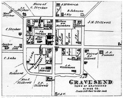
Gravesend’s original town plan has miraculously remained intact over the years. Roads divided the square plan into quadrants, in which there were 10 plots apiece. The east-west road in the center became Gravesend Neck Road, while the north-south axis is today’s McDonald Avenue. Avenue U ran northeast against the grid and skirts the northwest edge of the square.
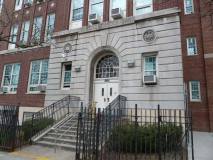
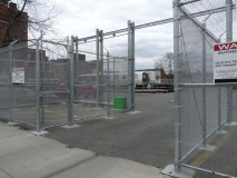
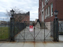
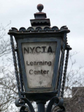
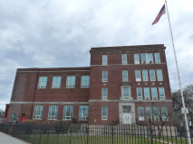
Avenue U begins at Stillwell Avenue and, one block in, encounters a grim-looking former public school with a subway car in its back yard protected by all manner of fencing, which was open to let through an exiting vehicle, though I had not the courage or foolhardiness to approach the subway car. Until 1981 this was PS 248, but it is now where MTA workers are trained in operations and safety measures. The subway car in the yard is an R-110B, a prototype car whose features later turned up in the R-143.
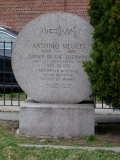
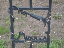
The true inventor of the telephone, Antonio Meucci, is honored at the triangle formed by 86th Street, West 13th Street and Avenue U. Meucci (1808-1889), whose house is preserved as a museum in Rosebank, Staten Island, had invented the telephone by 1860, but could not obtain a patent for it before Alexander Graham Bell obtained his, and thus Bell’s name passed into history while Meucci’s did not.
Fittingly a Verizon switching center is across the street from Meucci Triangle on West 13th.
BMT Sea Beach Avenue U station. Old subway appellations are rapidly fading from use; the N train in Brooklyn was formerly called the Sea Beach Line, because the steam train line it replaced went to the seashore Sea Beach Hotel in Coney Island. BMT stood for Brooklyn-Manhattan Transit, which itself had replaced the earlier BRT (Brooklyn Rapid Transit). The BMT built and maintained subways and trolley lines until its purchase by the city and subsequent consolidation with the Independent Transit (IND) and Interborough Rapid Transit) in 1940.
When the Sea Beach Line was placed in an open cut in Brooklyn in 1915, it built a nearly identical series of station houses, like this one.
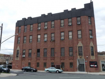
The George Clark realtor is still there, in the address advertised, at Avenue U and West 7th. On the roof are the necessary uglifications of our age.
Also on Ave. U and West 7th is the magnificent Bari delicatessen (“pork store”) which contains spectacular animal cannibal painted signage of a slavering, crown-wearing swine, the personification of the “king of the sausage” tag, holding a string of intestine-encased prepared pork. Bari, also the name of a kitchen supplies wholesaler on the Bowery, is named for a southeastern Italian city on the Adriatic Sea.
On this walk I paid special attention to the awning signs, as Avenue U has a great deal of vinyl and plastic lettered signs that probably go back to the 1960s or 1970s. The neon “Jewelry” sign probably goes back further than that.
Dairy Maid, which produces pasta and Italian delicacies in this still-predominately Italian neighborhood, features some impressive signage in the same vein. Named on the sign are manicotti, large pasta shells stuffed with white cheese; tortellini, ring-shaped pasta stuffed with meat and/or cheese; cavatelli, small oblong-shaped pasta; latticini freschi, fresh dairy products; translated on the sign.
I rarely see this kind of charlatanry occupying a complete storefront. They’re usually on the second floor.
Yet another 1980s vinyl and plastic sign. I wonder if Chinese restaurants have a random name generator.
At Avenue U and West 4th is a former post office; the pediment is inscribed with the date 1926.
The Gravesend Veterans Memorial at Lady Moody Triangle (Avenue U, Village Road North, Lake Street) features symbols of the Army, Navy, Air Force, Marines, and Coast Guard; a time capsule was buried nearby in 1987. The memorial subscribes to the theory that Gravesend drives from Middle English words meaning “end of the grove.” However, similar Dutch words mean “count’s beach” and a Dutch town is named ‘s-Gravenzande.
A pair of historic houses can be found on Village Rd. North opposite Lady Moody Triangle. #32 is the most altered by time, but some sources indicate it was constructed in 1788 as the Charles Ryder home. It was originally located at McDonald Avenue and Gravesend Neck Road, and, again, according to some, it served as a school when President George Washington visited it in 1790 during a tour of Long Island to thank various persons and municipalities that assisted the patriot army during the revolution.
Though nearby #38 looks older than #32, it was actually built a few decades later. The Ryder-Van Cleef House, originally located at 26 Village Road North, was moved here in 1928 to make way for the PS 95 playground that is still there. The house was built about 1840 by Lawrence Ryder and was owned later by his son-in-law John Van Cleef.
I detoured south on Van Sicklen Street, which runs north-south and forms the present western end of the Gravesend square street plan. The area south of Avenue U sees a number of odd alleyways and roads emanating from the street. Here, Lama Court, spelled Lamar on older maps, runs between Van Sicklen and West 9th.
Meanwhile, Lake Place, which goes back to the 1600s as a route from the Gravesend town center to the Narrows, presently runs west from Van Sicklen Street to 86th Street at West 11th. It is divided in two by the BMT subway, and only the section west of the subway is still a public street; the section wast was privatized and now swerves as driveways for homes adjoining it. I’m not sure if that was done legally. Lake is an old Gravesend name, and several Lake family residences were once scattered around the area. John Lake arrived from England in the 1650s and settled in what was then the only British settlement in Kings County.
Corso Court just east in a dead end from Van Sicklen Street south of Gravesend Neck Road. A former colonial-era Lake home once stood here, and the court, featuring handsome attached brick residences, was constructed in the early 1930s after the old house was razed. It’s marked by a remaining 1940s-era enamel and porcelain street sign.
PS 95, on Van Sicklen Street between Avenue U and Gravesend Neck Road, was constructed in 1915, likely by the prolific schools architect C.B. J. Snyder. A turreted residence belonging to a judge was displaced by the school, but it survives intact — it was moved to 2064 West 6th, a few blocks west.
That house greatly resembles this one, which is still in place on Van Sicklen Street opposite Gravesend Neck Road. According to disputed local legend it once belonged to the last mayor of the city of Brooklyn, Frederick Wurster.
The handsome brick church at the SE corner of Van Sicklen and Neck Road was constructed in 1937, (possibly) with Belgian blocks from the surrounding streets, and has belonged to the First Korean Church of Brooklyn since 1979. A number of churches had owned the building including the Coney Island Pentacostal.
The purported Lady Moody house stands at #27 Gravesend Neck Road.
There’s a debate going on about whether the house actually was the home of Lady Deborah Moody. If it was, it would make the house one of New York City’s oldest, since she died in 1659. Brooklyn historical records have Sir Henry Moody, Deborah’s son, selling the property on which the house stands in 1659 to Jan Jansen ver Ryn. It passed through various hands before winding up with the Van Sicklen brothers, John and Abraham, who may also have built the house in 1770. It’s heavily altered from when it was built, and in any case, this is one old house.
Two very old cemeteries, each of which go back the community’s beginnings in the 1650s can be found on the south side of Gravesend Neck Road opposite the Moody house. The first is the Van Sicklen family cemetery, which, despite yearly efforts to maintain upkeep, weds and vandals are a constant threat.
The second is Gravesend Cemetery proper, which extends south to Village Road South. The Old Gravesend Cemetery, across the street on Neck Road from the Moody house dates to 1643, the first year of the settlement. Lady Moody, according to legend, is buried in an unmarked grave somewhere within, although the oldest still-standing stone in the cemetery is dated 1724 and no stone has been found bearing her name. In the 1970s, these cemeteries reached their nadir with overgrown weeds, toppled gravestones and abandoned cars. Since then Gravesend Cemetery has been regularly mowed, and several historic signs and plaques explaining its significance have been installed.
Also, informative signage describing the Revolutionary War Battle of Long Island were erected.
Several decades ago a brick sidewalk was installed outside the cemetery gate. There had probably never been a sidewalk of any type before that.
Gravesend Neck Road passes under the Culver (F train) elevated at McDonald Avenue, which used to be the location of Gravesend’s town hall. The road runs southeast then northeast to Nostrand Avenue; that area, now landfilled, used to be swampy and the road led to a finger of arable ground within the swamp, called a ‘neck.’ Little Neck and Great Neck are named for small peninsulas, or necks, that jut into Long Island Sound.
I can never resist photographing Harold’s for Prescriptions at Avenue U and McDonald Avenue. I’m unsure if that glorious neon sign lights up at night.
Avenue U between West Street and East 1st Street. Louis Neglia is a three-time World Kickboxing Champion, a former U.S. Kickboxing Champion, a Florida Karate Champion, New York State Champion, and an Eastern American Karate Champion. No opponent has lasted more than three rounds against Louis Neglia since he won his first World Championship in 1980. Lou is an eight-degree Black Belt, and retired from competition in 1985 with a career record of 34 wins and only 2 losses. He was named Fighter Of the Year in 1984 and was inducted into the Karate Hall of Fame. He starred in four motion pictures (“A Hard Way to Die”,”Super Weapon”,”Fist of Fear”, and “One Down”, “Two To Go”). Featured articles have been written about him in the top American and International magazines and newspapers. louneglia.com
East 2nd and Avenue U. Modern residences strive to communicate anonymity, stolidity and inevitability (‘you will live in a place like this someday’). There is no concession to humanity or esthetics.
Or: the intention is to get across a DGAF sense of wealth (we’ll build this to keep you out, and who cares what it looks like).
Another set of vintage signs on Avenue U between East 3rd and Ocean Parkway. Especially witty are two stores, Twist and Twist and Shout, separated by Alice’s Restaurant. I wonder how many of the locals get the 1960s references.
No doubt a lot of motorists traveling north of Ocean Parkway wonder what this object is on the NE corner of Avenue U. I had long suspected it was a massive vent of some kind. Oscar Israelowitz, in his “Flatbush Guide,” finally provided the answer: it’s the air vent for the sewage pumping station beneath that intersection.
Another eclectic group of store signage east of Ocean Parkway. One reflects an increasing Russian population in the region.
Firehouses of a certain age usually carry plaques containing the year of construction as well as the mayor at the time and his staff. Engine 254/Hook & Ladder 153 was built on East 9th and Ocean Parkway in 1924 during the John Hylan administration.
The Lester’s empire continues to grow along Avenue U and Coney Island, with nearly a dozen storefronts bearing the name. It is actually a chain of stores founded in 1948 by Lester and Lillian Kronfeld; other locales can be found in Long Island and Westchester.
Nearby, Barton’s Sportswear hasn’t fared quite as well. As a matter of fact I found what might have been the last two sweaters in the shop.
Another hand-drawn and lettered sign, next door to Bartons.
Worn out. Time for a Q train back to town. The B and Q use this part of the old Brighton line; both cross the Manhattan Bridge, but the B goes up 6th Avenue and the Q, Broadway.
For more on Gravesend see Joseph Ditta’s Gravesend: Then and Now, and ForgottenTour #33 explored the area in 2008; with over 50 fans, it was one of FNY’s best attended tours.
5/5/13

