If you have been reading FNY for awhile you know I’m fascinated with the patterns produced by Queens’ occasionally wacko street numbering system (and I also speculate what it would have been like had the streets not been numbered, and colorful old names were retained. Some have been, and I will highlight those on a future page.
Beginning in 1915, NYC decided to number most of Queens’ streets to repair confusion that had sprung up. In effect, the city created a different kind of confusion, but in 1915 it seemed like a good idea. Beginning with European habitation beginning in the 1600s, a handful of major hubs such as Jamaica and Flushing had sprung up but Queens remained a county consisting of small towns here and there, connected by mostly dirt wagon traces — major roads were rare. Many of these small hamlets had their own numbering systems, and many had names like Main, Washington, Lincoln, and plant names — the kind you find in small towns everywhere.
So after Queens was annexed by NYC in 1898 and these small towns became more heavily urbanized, and farms were moving out and houses and businesses were moving in between them, the city decided to institute a uniform numbering system. However, a perfect grid, like the one in Manhattan and large stretches of Brooklyn, just couldn’t be accomplished in the sprawling county of Queens. It couldn’t be tamed that way, with uneven coastlines and hilly areas. So a specialized plan had to be implemented to make sure that a 60th Avenue, say, would be on the same latitude across the borough, generally speaking, and 60th Street would be on the same longitude.
In many cases, that meant skipping numbers. In Astoria, for example, to keep the old Van Alst Avenue as 21st Street all the way north and south, there are no 15th, 16th, 17th Streets, and 18th and 19th appear only in the far north near Astoria Park. Indeed, in the Hunters Point area we go from 5th Street to Vernon Blvd. (which kept its name) to 11th to 21st Street.
But often there were more streets than necessary, not fewer. So numbered streets other than Avenues and Streets had to be added. For east-west streets the pattern is that the first in the series is always Avenue, followed by Road, Drive, Court and Terrace. For north-south streets, it’s Street, followed by Place and then by Lane. In special cases with weird street layouts, like Fresh Meadows, Crescent and Circle were added into the mix.
This system presented occasions for maximum confusion when the same numbers would be encountered in the plan. This sort of thing happens on occasion in Manhattan (1st Avenue and East 1st and 2nd Avenue and East 2nd Streets meet in the East Village) and in Park Slope in Brooklyn, where 3rd Avenue meets 3rd Street, and so forth. But things are pretty simplified there because there are no Roads, Drives and Places to contend with.
Queens is a different bird because there are hundreds of opportunites for the Clash of the Same Numbers to arise. Fortunately, though, it doesn’t happen as often as you think.
Single numbered Avenues (etc.) occur only in Whitestone, so they don’t meet the single numbered Streets (etc.) in Astoria and Hunters Point. Ditto for the Teens. There’s a 20/20 corner, and 21st Street meets Avenue, Road and Drive in northern Astoria. 23/23, 24/24, 30/30, 34/34, 35/35, 36/36, 37/37, as well. In Sunnyside, 43rd Avenue meets 43rd Street, and there’s 47/47 and 48/48. And then, there’s Maspeth, and the concept goes nuts.
56th Road, 56th Street and 56th Drive come together by the LIRR railroad tracks, and 56th Terrace is nearby. 58th Street encounters 58th Avenue and Road, as does 58th Place. 59th Street and 59th Place meet 59th Drive.
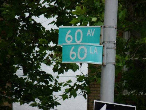
But as for 60 … juts about every combination is accounted for. I took a walk around and inspected the Land Where Every Street is Named Sixty.
6oth Avenue and 60th Lane

PS 153 takes up the east side of the block on 60th Lane between 60th Avenue and 60th Road.
60th Road and 60th Lane
Some pleasant-looking attached brick homes can be seen at this interesection.
60th Drive and 60th Lane
Some more houses, cut from the same mold.
Heading west on 60th Drive…
60th Drive and 60th Place
A pair of very short streets help to complete the picture. 60th Drive encounters 60th Place, where one of the same houses seen above has a luxuriously green front yard. Heading south on 60th Place…
60th Place and 60th Court
… a pair of sun-bleached signs announce the presence of dead-end 60th Court, which we’ll see again. 60th Place is a dead end too, since it has no outlet. Heading back up 60th Place and to 60th Drive again…
60th Drive and 60th Street
…at 60th Drive and 60th Street is a small house of likely great age, coated in siding. We head south on 60th Street, which bridges over Long Island Rail Road tracks, and encounter likely the most interesting item on this Walk of Sixties.
60th Street and 60th Court
60th Court, off 60th Street, is a short gravel court that seems to lead past a couple of Dumpsters®. But give this little alley a chance. Riches await you.
Metropolitan Oval
It seems almost too good to be true: a picturesque and well-maintained soccer field featuring terrific matches every week with the spectacular skyline of midtown Manhattan as the backdrop. On a gravel path called 60th Court west of 60th Street, next to the Long Island Rail Road tracks, you will find one of Queens’ — and indeed New York City’s — most overlooked treasures.
The Metropolitan Oval has been used continuously for soccer since 1925. Soccer greats Tony Meola, Werner Roth, Tab Ramos and Edson Nascimento (Pele’s son) have all called Metropolitan Oval their home field at one time or another. The field is a U.S. Soccer Development Academy and seeks to develop the best young soccer talent in the region. The field hosts up to 20 games per week and is the home field for a number of local college teams.
Met Oval had fallen into decrepitude and disrepair a few years ago (even now, it’s practically invisible from the street and you have to walk past a few dumpsters to reach the entrance) but half a million dollars from the U.S. Soccer Foundation and Nike turned it around, providing it with FieldTurf, a state-of-the-art playing surface.
Heading north again on 60th Street…
60th Street and 60th Road
At 60th Street and 60th Road, nothing much to write home to Mother about, just a one-story warehouse. But…
60th Street and 60th Avenue
On the SE corner is the compact brick Trinity-St. Andrew’s Evangelical Lutheran Church, constructed in 1940. The address is 60-06 60th Street, and don’t tell me that’s random.
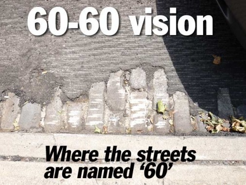
60th Avenue has been scraped in anticipation of a new street pavement. That means that this bit of original paving stones has been exposed, but will soon be covered up again.
60th Avenue and 60th Place
60th Place is a short Lane between 59th Drive and 60th Avenue lined with pairs of residential buildings separated by driveways.
The axis of like-numbered encounters continues in a general southeast direction in Queens. 62nd Street meets both 62nd Avenue and Road. There’s 70/70, 77/77 and 78/78 encounters in Glendale. Then the action shifts south of Forest Park to Woodhaven and Ozone Park, where 85th Avenue, Road and Drive all meet 85th Street. There’s an 86/86 meeting, 88/88, 89/89, 91/91, 95/95, 97/97, 101/101, 103/103, 107/107, 109/109, 111/111 (six same digits is the most in a NYC intersection), and near Kennedy Airport there’s a 131/131, 133/133 and 135/135. And that’s it — the number combinations don’t encounter each other south of that.
UPDATE 6/28/13: I forgot about Brooklyn, where in Brighton Beach there’s a nearly unparseable group of numbered Brighton Streets — some of which are mere walkways and all of which used to have names.
The largest number intersection in NYC is in Rosedale, where 149th Road meets 259th Street, making 408. The smallest is the aformentioned 1st Avenue and East 1st in Manhattan, making 2.
6/23/13
