

Long before DUMBO (“Down under the Manhattan and Brooklyn Bridge Overpasses”) had a name, it was an industrial grid with manufacturing and warehousing. Its extreme eastern flank remained residential and has long been known as Vinegar Hill.
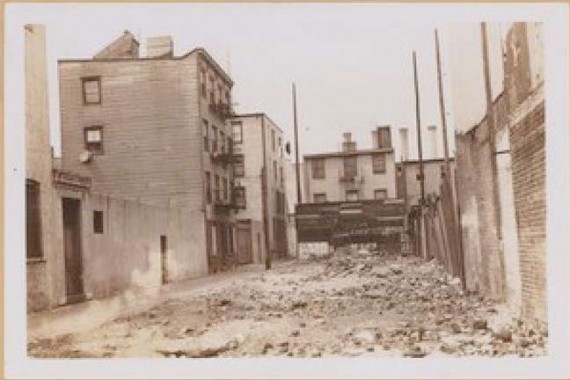
Before 1950 or so, both DUMBO and Vinegar Hill had an outsize number of short alleys, as is shown in my Street Necrology of Downtown Brooklyn. To me, and pretty much everyone else alive today, these are just names on maps. The NY Public Library has one of them in its collection, though, as seen here.
Seen here is Dixon Place, which ran two blocks between Sands and York, just west of Navy. In the early 1950s much of eastern DUMBO and southern Vinegar Hill were wiped off the map by the Farragut Houses, which paved over most of the alleys. School construction created some “superblocks” and eliminated many streets west of here as well, including quite a few alleys with piquant names like Nutria Alley, Gothic Alley and Way-Home.
Here’s a snapshot into a distant past that has been paved over and … forgotten.
7/10/13