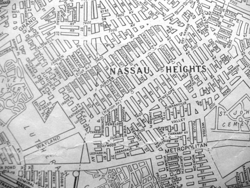
Once again, let’s blow the dust off a 1922 edition of a Hagstrom 5-boro map that I furtively captured with a digital camera on a long-ago day ay the Map Room of the New York Public Library on 5th Avenue. The attendant had told me that there was no way the map could be photocopied, not because of a copyright issue but because the map was in poor shape and couldn’t hold up in a drum scanner. Otherwise, I’d have the whole darn thing. This way, I was only able to get selected slices.
So, let’s note the differences between this and today’s map. For one thing, no one calls the neighborhood Nassau Heights anymore. The southern section is Middle Village, the middle was developed as Juniper Park in the 1930s, and the north end is an eastern section of Maspeth or the west end of Elmhurst (there’s debate over the boundary line).
Eliot Avenue is missing. It was not cut through the area until the mid-1930s. Therefore. Mt. Olivet Cemetery abuts Lutheran (All-Faiths) Cemetery. The Wayland Avenue that cuts through Lutheran Cemetery is no longer there. The mapped 61st Avenue later became Eliot Avenue. 61st Avenue is an odd numbered avenue in Queens in more ways that one — today it runs only in Glen Oaks.
Many more streets are named. In 1922 the Queens numbering system, adopted in 1915, hadn’t yet reached several neighborhoods. The map notes the old names along with the new numbers. Note that Mazeau Street extends much further south than today. My favorite street name in Queens, Juniper Valley Road, was kept after the numbers took over. Some other names have survived too, like Dry Harbor Road, Penelope Avenue, Gray Street, Pleasant View Street and others.
