

So, it was October 1975 and I’m age 18 and furiously pedaling down Rockaway Boulevard all the way out in Brookville in southeast Queens, quite a ways from home when you consider that I lived in Bay Ridge between 1957 and 1993. I was fascinated to see the median filled with Twin versions of what I learned later were type F lampposts. As far as I know, there’s no known record of their being there… who took pictures of lampposts then? Few do now! Type Fs were short in stature, and the Department of Traffic retained them there because Rockaway Boulevard runs near Kennedy Airport, and in spots around airports, lampposts are kept short in stature so pilots will not mistake them for runway lights!
I later learned that later the same year, the Type Fs were replaced with double Deskeys and those posts have since been replaced. It’s been 40 years now and I still remember this distinctly.
There’s one other thing I remember, though: I exited Rockaway Boulevard by actually crossing the road (that’s pretty dangerous, since it’s a speedway) and climbed back up to the surrounding Brookville neighborhood by using a dirt road that ran through the fields and swamps (much as nearby paved, two-lane Brookville Boulevard does). The road was signed as Springfield Lane (NOT Springfield Boulevard).
Over the years, I explored the history of this road with maps.


In 1873, few roads went through eastern and southern Queens, but the ones that did are still there. I have labeled three of the ones shown here: New York Avenue (Guy Brewer Boulevard); Rockaway Turnpike (Rockaway Boulevard) and Springfield Road (now Springfield Boulevard). The other names on the map denote who owned what property. Most of this was open country, though there’s a new development on the left. Everything west of Rockaway Turnpike is now in Kennedy Airport.
Note that Springfield Road ends at Rockaway Turnpike.


Skipping ahead 76 years to 1949, this Hagstrom map represents not what the street layout wa actually like, but what developers hoped to build there. In reality, none of the streets south of 148th Avenue and around the creeks shown on the right were actually built; they are “paper streets” only, though Brookville Boulevard, marked by the thin red line signifying a bus route, did twist and turn through the swamps south to Rockaway Boulevard.
And, Springfield Lane also makes it all the way to Rockaway Boulevard, splitting from Springfield Boulevard south of 146th Avenue. Actually Springfield Lane is what remains of the ancient roadway of Springfield Road, laid out during the colonial era.
Hagstrom at that time expected Rockaway Boulevard to become an expressway, since it is shown with straight lines that don’t intersect the other streets. Nassau expressway was expected to parallel Rockaway Boulevard, but it was never fully built.


Much of what Springfield Lane is mapped through is still pretty much forest, an undeveloped “park” called Idlewild Park or Brookville Park on maps.


Zooming in closer, though, you can see there’s no road under the gray line.
Also, you can see that the spot where Springfield Lane met Rockaway Boulevard is now at a corporate park and parking lot and there’s no trace remaining there.


From an aerial view, you can see that Springfield Lane is a paved road as far south as this open work yard.


Springfield Lane also turns into a dirt road just south of 149th Avenue, at the top of the photo.
Another stumper: what is the circular area of cut grass all about?


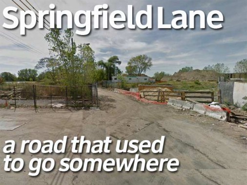
Friends of Idlewild tweeted me a photo of Springfield Lane as a dirt road. I must have bicycled on this back in 1975.


This is the southern limit of today’s Springfield Lane at 149th Avenue. If you continued south, you would be on private property and would be shooed out.


And, this is the southern end of Springfield Boulevard at Sprinfield Park. Here, Springfield Lane, the true route of Springfield Road, runs off to the left.
There is a dead-end portion of Springfield Boulevard on 147th Avenue, south of here, but this is it, for all intents and purposes. The road roars south through eastern Queens, mainly as a 4-lane divided highway, from Northern Boulevard to FDNY Engine 311 / H&L 158 at 145th Road, where the other lanes peter out and Springfield Boulevard becomes a 2-lane regular road.


And one more thing: I experimented with the Clearview font for my pages dealing with roads. Those on mobiles can’t see the title cards, so I repeated it here.
What do you think?
5/27/15