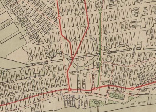
I was recently tipped off to the downloadable presence of some 1922 Hagstrom maps of NYC, at least 4 boroughs minus Staten Island, on the New York Public Library website Digital Collections.
Allow me to reminisce. I may have mentioned this previously, but I have been fascinated with street maps almost since birth, especially my hometown NYC. My first Brooklyn map was a Hagstrom purchased at the Gertz Department Store on Jamaica Avenue in the late summer of 1968. The old man was there to purchase a wood wall unit for his stereo equipment. Mission accomplished: he stuck with what we got to his dying day in June 2003. We went to a restaurant and he sent the steak back twice because it was pink in the center (on that, at least, he and Donald Trump could talk about something). And we got that Brooklyn map. It wasn’t my first map: prior to that, I’d been collecting Geographia’s “Little Red Book” street guides I purchased from newsstands; I already had Brooklyn and the 5-Boro editions, both of which came with a folded-up black and white map glued within.
It only got worse from there. I saved money and in the fall of 1971 purchased just about every city street map all over the country that Geographia offered in a mail order. I watched for when the mailman was coming like a hawk if I was home. That same fall, my mother and I journeyed to what was then Hagstrom headquarters in the same building on West 33rd near 10th Avenue that the NY Daily News has offices in today. I came away with the Philadelphia-Camden folding map (Hagstrom also made a Philly atlas, but I never acquired one until approximately 15 years ago.) Hagstrom later moved to Maspeth, Queens; in 1982 I interviewed for a job with them on West 33rd, tried again in 1992 in Maspeth, and came up empty both times.
In the 1980s, I worked nights. Often, I would get a train into midtown in the afternoons, head for the NY Public Library at 5th Avenue and West 42nd, head for the Map Room and look over their NYC editions, especially the early edition Hagstroms. The library folks would tell me they couldn’t scan them for me, since the drum scanners would damage the maps. When digital cameras came along in the 2000s, I had to be content with photographing sections laid flat on the tables, with middling results.
Apparently that scanning problem has been resolved, since here the 1922 Hagstroms are on the NYPL site!
Today, I’ve cropped Coney Island from the 1922 Hagstrom. For the most part, Brooklyn streets, except in outlying regions near the water like Bensonhurst, Coney Island and Bergen Beach have remained the same for decades, except for their elimination by expressways and housing projects.
That’s pretty much what has happened with Coney. I think the thing that sticks out when comparing 1922 to today’s map is Coney Island Creek extending all the way to Sheepshead Bay via the Gravesend Ship Canal. As FNY Correspondent Sergey Kadinsky explains in the Hidden Waters blog, this was a canal on paper that never existed and indeed, the actual zigzagging nature of Coney Island Creek was the actual reality then and now. The Belt Parkway was built approximately where the canal was going to be built.
However, the Canal Avenue the developers hoped to bruit through Coney Island was actually started and exists in two pieces, one at Cropsey Avenue and the Belt Parkway that serves as a handy dandy bus turning venue, and another short piece further west in Sea Gate. Both pieces were once meant to be continuous, eventually, but never were connected.
Note the red and green lines on the map. These are elevated trains, today’s D, F, N and Q, that still run to the Stillwell Avenue Terminal. At the time, Hagstrom was showing elevated trains as green and subways as red. However, because of the marshy terrain, there are no subways in Coney Island; the red lines eventually submerge underground.
Also note the dotted line midblock between Surf and Mermaid Avenues. this was the Norton’s Point trolley line to Sea Gate that ran through Coney Island backyards. It was eliminated in the 1950s and most traces of it have now been wiped from existence.
There’s a little network of streets south of the proposed canal between West 8th Street and Ocean Parkway. They comprised a minor neighborhood that was also eliminated in the 1940s by first the Belt Parkway and then by the construction of the Luna Park Houses and (Fred) Trump Village.
Also: Long Island City and Sunnyside, Hagstrom 1922
“Comment as you see fit.” kevinjudewalsh@gmail.com
1/18/17
