

I’m fascinated with a Dripps atlas of Queens made in 1852 I stumbled on awhile ago, as I am with most old maps. At that remote time Millard Fillmore was President (he had assumed office after the death of Zachary Taylor; as it turns out there had been a Zachary Taylor Sports Bar on Vleigh Place in Kew Gardens Hills, and Millard Fillmore’s on 65th Avenue in Pomonok).
If you look at this map, which encompasses the southern part of Flushing, which is known to some as Pomonok; it’s south of Flushing proper but north of Jamaica Hills. This far west there were no major east-west roads in between the Flushing and Bayside Plank Road (now Northern Boulevard) and the Hempstead and Jamaica Plank Road (now Jamaica Avenue). Queens itself was much larger than now, as it encompassed all of Queens and Nassau Counties; the three eastern towns became their own separate county, Nassau, in 1899, partly because Queens County had voted to become part of Greater New York City, and partly because those towns wanted the county courthouse to be in Mineola, not Long Island City, for better convenience. It’s hard to imagine these days how difficult it might be to govern a Greater New York that also included what is now Nassau.
I’m struck by how wide open the borough is. Mid-Queens was still quite swampy and there were large empty tracts, with cart paths going through them. In some cases, they were wide enough to allow horse-drawn coaches. The really major roads were overlaid with wood planks, hence their “plank road” names.
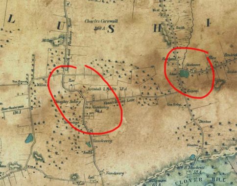
I’ve circled on the left the junction of what is now Kissena and Parsons Boulevards. Those roads were in existence then as a continuous road from Flushing to Jamaica, with a curious S-shaped bend. The bend still exists as Aguilar Avenue, while Parsons Boulevard was extended north and, with several interruptions, now goes to the East River in Malba.
The road now shown as Quarrelsome Lane disappeared in the early 1920s when a grid system was overlaid on the area, but it approximates the present location of 76th Avenue.
I’ve circled on the right a bend in a road to get around a pond. The pond was drained and is now the Utopia Playground; the north-south road is Fresh Meadow Lane, later straightened as Utopia Parkway; and the road that dodges around the pond is the east end of Jewel Avenue. The road that runs straight east from there is Black Stump Road, which by legend was named because local farmers used blackened, burned stumps to mark property lines. It is now 73rd Avenue.
I’m having fun with this old map, so I’ll be doing more entries.
Check out the ForgottenBook, take a look at the gift shop, and as always, “comment…as you see fit.”
8/29/17