
I hadn’t sallied up Morris Park Avenue in the Bronx for some time — not since 2006-7 or so, and on this sort of hangdog afternoon on either side of Christmas, I figured it was time.
Morris Park, located in about the exact center of the Bronx, appears to be one of the borough’s most stable and long-standing neighborhoods, but it’s only a few decades old and occupies what used to be a vast racetrack. Many of NYC’s more “stable” neighborhoods, such as Sheepshead Bay, Brooklyn, are located where the ponies used to run and automotive pioneers raced.
The name Morris turns up a number of times in the Bronx, primarily from two different families: the Revolution-era Morrises: Richard, who arrived in the 1660s and first settled the South Bronx; Declaration signer Lewis, US Sen. Gouverneur, and Robert, who was a three-term NYC mayor in the 1850s.
The Morris of Morris Park was John A. Morris, whose Westchester Racing Association acquired 152 acres in 1888 on the outskirts of the old Bear Swamp and built a racetrack and clubhouse there. As opulent as the racetrack was, though, it was in operation from only 1890 to 1904 (though a vestige of horse racing in the area, the Track Restaurant and Tavern, held down a corner at Eastchester and Williamsbridge Rds. some distance from the old track until 1957). The track itself burned to the ground in 1910.
In 1908, the abandoned racetrack became the world’s first formal airfield and the American Eagle, the largest dirigible in history to that time at a full 105 feet in length, was built there, and one of the first gliders, piloted by 17-year-old Lawrence Lesh, was launched from the former track that year. And, in the early-1900s, the old racetrack was also used for speed and endurance races for the newfangled automobile, and a young Swiss driver named Louis once won a gold watch for driving a Fiat a the-record 52.8 MPH there. The driver, along with his brother Gaston, competed in many road races at the Morris Park track and Gaston won at Indianapolis in 1920. Of course, it was Louis Chevrolet (1878-1941), who ironically sold his share in the Chevrolet Motor Car Company he founded in 1911 to original partner William Durant in 1915, and returned to the racing business, as well as aeronautics. (The gold watch he won had been donated by Walter Chrysler.)
It wasn’t until the 1920s that streets were cut through and houses constructed; the neighborhood was not “completed” until the 1970s!

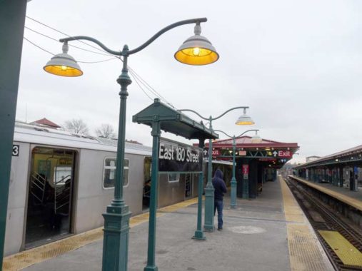
I took the #2 train from Penn Station to East 180th Street, which has some decorative platform signboards and lamps. The lamps date back to a station renovation of about a decade ago (mid to late 2000s). If I were to stay on the #2 I would go up the el above White Plains Road to wakefield, near the border with Mount Vernon. I could transfer across the platform to the #5, which uses the right of way of a former commuter railroad, the NYW&B (see below). Instead, I walked down to Morris Park Avenue and headed east.

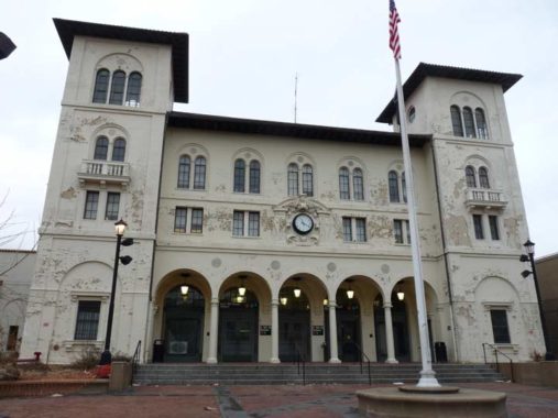
The building above at E. 180th St. and Morris Park Ave., which exhibits an air of faded magnificence, was constructed in 1912 as a grand Italian villa station for the New York, Westchester and Boston Railroad that operated between the Bronx and Westchester from 1912 to 1937 (it never made it to Boston) and was subsequently sold to NYC and became the Dyre Avenue Line.
It currently serves as a simple portal for the E. 180th St. station, serving the #2 and #5 trains. Though it was renovated in the last five years, receiving a new gleaming white paint job, the lowest bidder strikes again, and the paint job is already peeling off.

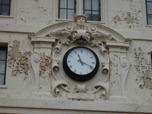
The clock tells correct time, but Mercury in his winged helmet looks a little displeased at that peeling paint job. Mercury, in Roman times the messenger god, was known for his speed, and the NYW&H and his symbols, including a winged staff entwined with two snakes, were used on railroad overpasses and stations.
The NYW&H, by the way, shouldn’t be confused with the New York, New Haven and Hartford RR, a little east of here, which was absorbed by NY Central. Its trackage, now used by Amtrak, is now slated to become home to the Metro-North and open 4 new Bronx stations by 2023, with the line terminating in Penn Station.


I may have said it already on previous pages, but the Morris Park station is among my favorite subway stops in the city. Its large station house was formerly home to a police precinct, and its hanging pendant lamps, exposed columns and rivets hark back to a golden age of railroading. Remember, as first conceived this line was supposed to go all the way to Boston.

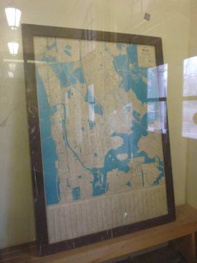
There are a number of picture windows just inside the entrance. In one of them is a mounted Hagstrom map of the Bronx. The map cannot be younger than 1973, because the Third Avenue El is shown on the map. In 1973, the old el was cut back to a shuttle lien between the Hub and Fordham university; formerly, it had been bridged over the Harlem River, connecting to Manhattan’s 3rd Avenue El which ran from the 1880s to 1955.

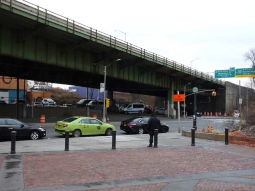
Here the Bronx River Parkway is bridged over Morris Park Avenue and East 180th. The parkway originates in the Soundview neighborhood and runs into Westchester County and beyond. Unlike White Plains Road, this is a direct route to White Plains, north of which it become the Taconic State Parkway. Its oldest section in Westchester opened at the dawn of the Auto Age in 1907!

US Representative Paul Fino (1913-2009) was elected to the State Senate from 1946-1950 and elected to Congress in 1952, where he served eight terms, and then the State Supreme Court in 1968. He was known for his staunch opposition to Mayor John Lindsay, who he considered too moderate. In 1972, he sentenced a 17-year-old to 30 years in prison, who’d been convicted of selling one-seventy-third of an ounce of heroin.
This painted sign on Morris Park Ave. and Adams St., one of two surviving campaign ads for Fino, was likely made in the 1960s for one of his State Senate campaigns.
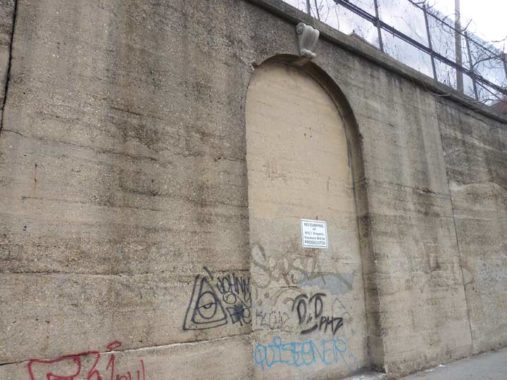
Morris Park Avenue is separated from the 180th Street/Unionport subway yards servicing the #2 and #5 trains by a high concrete wall. At about Melville Street you see this filled-in archway, with a small sconce above it. There’s probably a story behind this, but at this point I’d guess that it was once a simple entrance to the yards.

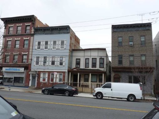
590 (left) to 582 Morris Park Avenue, east of Melville. 590 in particular has retained some of the appearance it had in 1940. These buildings likely date to the late 1800s.

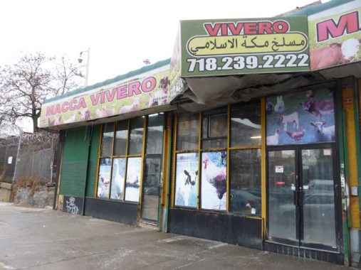
Macca Vivero, a meat wholesaler/slaughterhouse at Morris Park Avenue and Garfield Street.

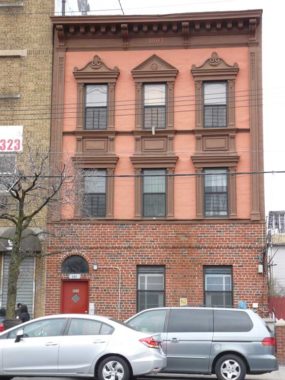
608 Morris Park Avenue, likely the best-preserved building in this stretch, has its original window lintels.


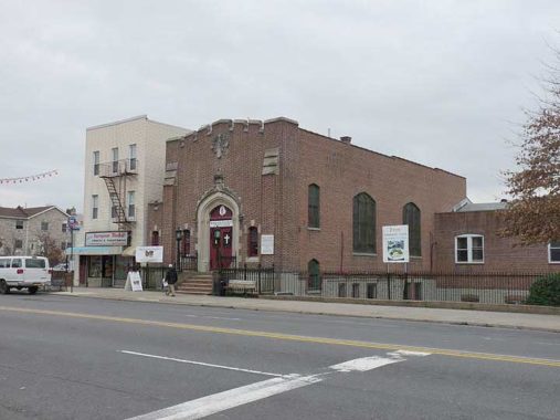
This section of the Bronx is Italian, Albanian and Latino and is chockablock with Catholic parishes. The one serving the west end of Morris Park Avenue is St. Dominic. The parish was established and the church constructed in 1925. Inscribed above the front entrance are the Latin words, Domine, dilexi decorem domus tuae (“Lord, I have loved the beauty of your house”) from the Old Testament Psalm 26.
St. Dominic merged with the nearby Our Lady of Solace parish (see below) approximately a decade ago (as of 2019).


Unionport Road is one of the Bronx’s oldest routes, running diagonally from about Bronx Park southeast to Westchester Avenue through the former Catholic Protectory, now the site of the Parkchester housing development. There was a former community known as Unionport as well, in southern Castle Hill. Unionport was a mecca for German and Irish immigrants in the mid-to-late 1890s. After the eastern Bronx was annexed to NYC in 1895 the streets were renamed for local luminaries and settlers, and Unionport was absorbed into what’s now Castle Hill.
Before the Parkchester housing complex was built in The Bronx, it was the site of the New York Catholic Protectory. The Protectory was created in 1863 as a home to care for destitute or truant children. The need for the Protectory grew out of the reality of thousands of vulnerable Catholic children wandering the streets of the city and fending for themselves. [Academic Works, CUNY]
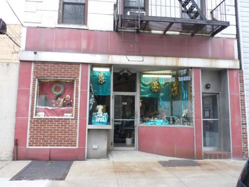
Vatican-Mater Dei Church goods, a Catholic supplies shop across the street from St. Dominic at 1738 Unionport Road.

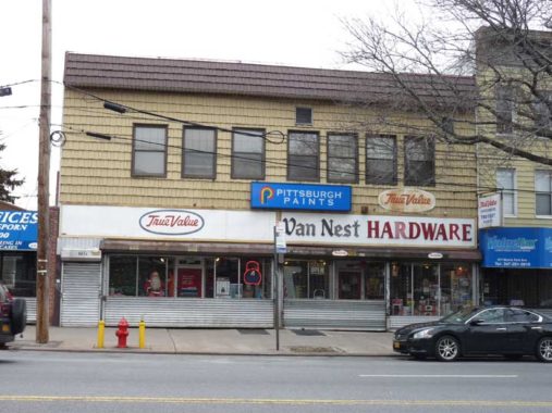
Van Nest Hardware, #669 Morris Park Avenue. Actually, Van Nest Avenue is a block south of here, but asection of Morris Park is also called Van Nest.
Van Nest is an old name and comes from Dutch colonial settler Pieter Pietersen Van Neste, who arrived in North America from Holland in 1647. However, the family is only honored here because of the Van Nest Land & Improvement Company, which began developing the neighborhood in 1892. Scions of the Van Nests became railroad company directors and developers but according to Bronx historian John McNamara, no Van Nest actually lived in the Bronx.
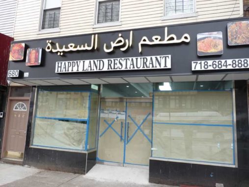
It’s likely that the owners of Happy Land Restaurant at #680 near White Plains Road are new to the Bronx; otherwise, they wouldn’t have gone near this name. The Happy Land social club, on Southern Blvd. in West Farms, was set afire by an arsonist on March 25, 1990, killing 87 — making it one of NYC’s worst massacres to date.


The wheels of technological change grind slowly in Morris Park. E.S. Business Machines, #704 Morris Park Ave., east of White Plains Rd., still promotes its typewriter repair service prominently in its display window, and the awning (which appears as if it was constructed recently) touts fax service and cash registers, as well. According to Baruch College, owner Sam Vasquez, born in 1937, has owned and operated the store in Morris Park since the 1980s, and before that in lower Manhattan. While praising the new computer technology that largely eliminated typewriters, Vasquez claims he still gets adequate business from young writers who wish to compose the old-fashioned way. I still have my 1940s Remington, and keep it around in case the grid fails. I need a new ribbon, but now I know where to find one.
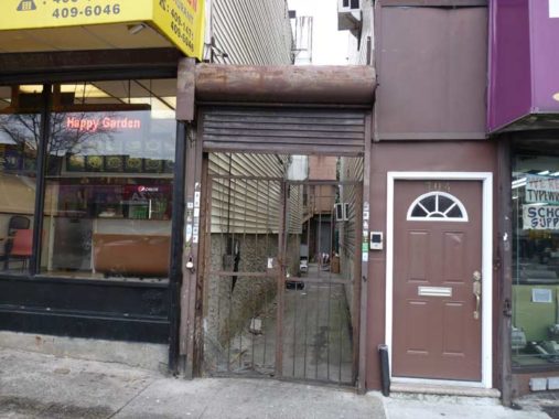
A passageway at #704 appears to lead to a backhouse, a separate house on the same property that carries a different house number.


The Spanish-style Lucchese Funeral Home at Hunt Avenue was constructed in 1921. It looked pretty much the same in 1940. Note the rock outcropping to the left of the church in the 1940 photo. It was blasted a way years ago and the space is now a parking lot for the funeral home.

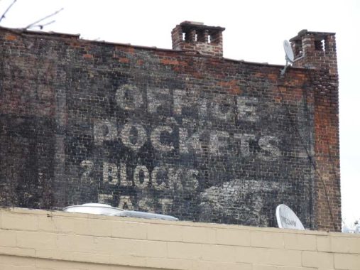
Here’s a “faded ad” seen on the west side of #742 Morris Park Avenue with a fickle finger point two blocks away where there is an “office and pockets.” Any idea what this could be?
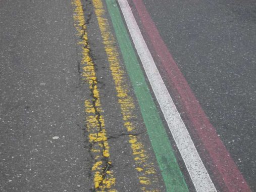
As a nod to the many Italian Americans in Morris Park, the center median of MPA is painted in the red, white and green of the Italian flag.


Our Lady of Solace Roman Catholic Church, its rectory and former parochial school (now the Bronx Charter School For Excellence) dominate MPA at Holland Avenue. The church was established in 1928, one year after St. Dominic a few blocks away, which have combined to form a single parish, with both church buildings open for worship.
Yet another Morris Park Avenue house of worship is this Seventh Day Adventist Church between Barnes and Matthews Avenues. The Adventists are a Protestant Christian sect co-founded by Ellen White in 1863.


I’ve always been fascinated with Graham Place, a dead-end alley on the north side of Morris Park Avenue between Matthews and Muliner Avenues. However, today, I found the entrance fenced off.


I wanted to get new photographs of the two residences on Graham Place, #191 and 193. There’s more than one way to skin a cat. I walked around to Matthews-Muliner Playground, and you can see them through the wire fence on the basketball court. I believe the two buildings are no longer occupied, and a new building may go up in their place, wiping all trace of Graham Place off the map.

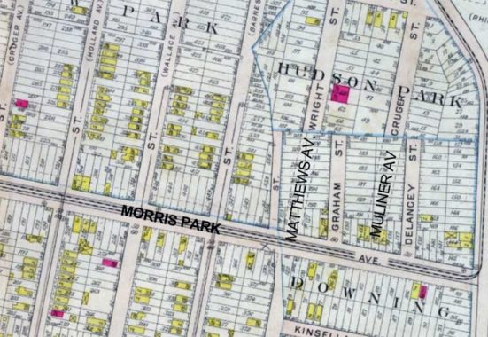
What is Graham Place doing here, anyway? A partial answer can be found when you look at a 1902 map of Morris Park. Back then this was a planned development called Hudson Park, and two small streets were mapped: Graham and Delancey Streets. Graham Place barely survives…


…while Delancey (Place) was fully developed and is now one of NYC’s few L-shaped streets. Muliner Avenue was built on a NW-SE axis and Delancey Street was jogged over a very short block to meet it.
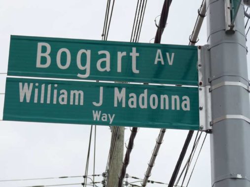
Formerly, when the city wanted to rename a street, they went “whole hog” and renamed the street for its entire length. For example, north of Central Park, 7th and 8th avenues were renamed Adam Clayton Powell Jr. Boulevard and Frederick Douglass Boulevard in the 1970s. Down went the 7th and 8th Avenue signs, and up went the new signs. However, so many people are honored these days that the old names are retained and just short portions of streets get what I call “subnames.” Who are the people honored? At his site, NYC Streets, Gil Tauber has the answer:
William J. Madonna (1961-2017) was educated at Northeastern University and the New England School of Law. He began his legal career in the office of the NYC Corporation Counsel. and later joined the Bronx District Attorney’s Office as a prosecutor. From 1994, he had a successful private practice in the Morris Park section of the Bronx. He represented victims of domestic violence, as well as handled divorce and family law, criminal law and real estate. He was a member of the Bronx County Bar Association, the Bronx Family Court Bar Association and served as chief counsel to then state-assemblyman, Mark Gjonaj. He represented the Tracey Towers tenant organization in their fight to block rent increases. He also represented the Friends of Pelham Parkway in its successful lawsuit to save the trees that were set to be removed for the reconstruction of Pelham Parkway.
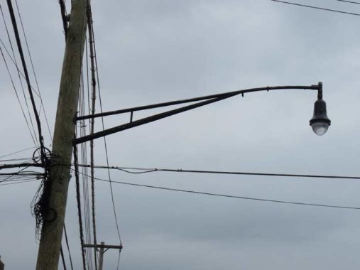
This section of Morris Park Avenue is unusually illuminated. Double mast telephone lamps like this are fairly common in NYC, but they’re usually not paired with Bell fixtures. However Morris Park Avenue got a makeover about 15 years ago (writing this in 2019) and the DOT came up with this combination. It’s also employed on Williamsbridge Road, but I can’t find it elsewhere in the city.


The Morris Park NYPL branch at #985 MPA features a contemporary design. According to the Library it opened in 2006, making it the first library in Morris Park. Since the area was developed in the early 20th Century I found that a bit incredulous. Where’s the next nearest branch?
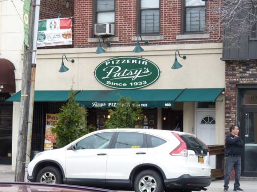


Further east on Morris Park Avenue, its Italian identity comes more to the fore, with fireplugs painted in red, white and green and a Patsy’s pizza outpost. The original Patsy’s was founded by Pasquale “Patsy” Lancieri in East Harlem in 1933, making it one of NYC’s earliest pizzerias. Brooklyn’s Grimaldi Pizza, of the lengthy tourist lines on Old Fulton Street, was founded by Lancieri’s nephew. The midtown Patsy’s on West 56th Street, patronized by Frank Sinatra and other celebrities, was founded by a different Patsy, Pasquale Scognamillo, and is not associated with the Lancieri Patsy’s.
The Morris Park Patsy’s sign proclaims “since 1933,” and my guess is that they’re an outpost of the original Lancieri Patsy’s of East Harlem.

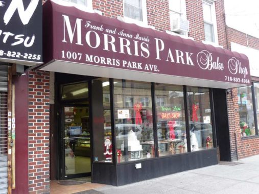
This awning sign features the serif fonts, Bodoni and Baskerville.

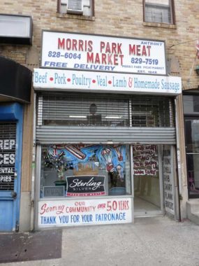
Old-school sidewalk signs on the Morris Park Meat Market.
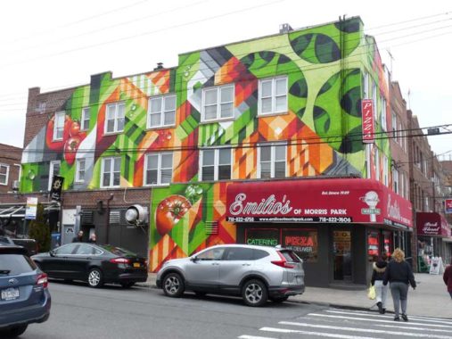
Brightly colored building art at Emilio’s of Morris Park at Hone Avenue. It’s reminiscent of Brazilian artist Eduardo Kobra‘s work.

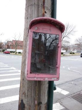
This fire alarm box has been decommissioned, and someone decided to put a see-through plastic panel at the front. One wonders what will be displayed there. As a rule, New Yorkers use old alarms as trash receptacles.


Eastern Morris Park is the borough’s Hospital Row, as Jacobi Medical Center, on a vast plant between Pelham Parkway, Eastchester Rd., Morris Park and Seminole Aves., is the Bronx’ largest public hospital. Also in this stretch are the Belfer Institute, the brooding Albert Einstein College of Medicine, the airier Michael F. Price center for Genetic and Translational Medicine (shown above), Bronx Psychiatric Center, Montefiore Medical Center on Eastchester Rd. and Calvary Hospital, where my father rested comfortably in his final days.
The streets in this section of Morris park curve around, and they were once part of a late 19th Century development called Westchester Heights. Some streets were given Indian-sounding names, such as Seminole, Choctaw, and Pawnee. Much of the old development was replaced by Hospital Row beginning in the 20th Century.


Morris Park Avenue comes to an end at Bassett Avenue, which runs along the Amtrak Northeast Corridor tracks. This is the former NY, NH & H tracks that are planned to include Metro-North service to Penn Station by 2023. As a rule, commuter railroad fares are more expensive than mass transit, and it remains to be seen if new Bronx Metro-North stations will get much patronage, as residents here tend to be poorer than those living in Westchester County.


Intending to finish at Pelham Bay Park, I struck north on Stillwell Avenue, which is lined with auto repair shops. At McDonald Street I saw something unusual. Signature Chrome Customs is also a barber shop! What an unusual combination. Can anyone shed a light on this?


I hadn’t been on Pelham Parkway lately, but I see they have a new set of davit-style lamps (davits have no mast; the shaft curves over the road, with the fixture placed at the end). They have been used more and more frequently on NYC streets over the past decade.

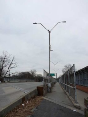
Meanwhile, this two-angled mast, used mostly in industrial areas, has been losing out. A few pairs show up on the bridge that takes Pelham Parkway over Amtrak.

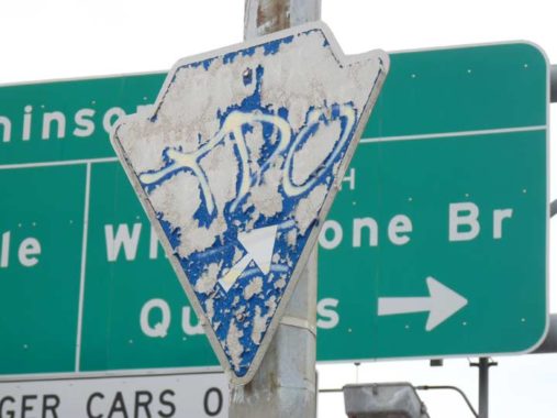
I found an ancient “arrowhead” sign pointing traffic toward the Bronx-Whitestone Bridge. A much larger green sign in back of it does the same thing.


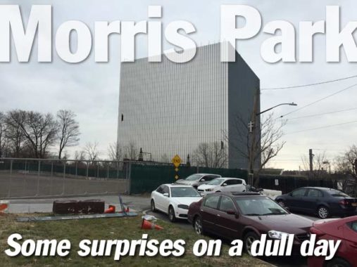
At Stillwell Ave. and Pelham Parkway, you find this stolid structure, opened in 2016, that resembles Star Trek’s Borg Cube, or perhaps the Ministry of Truth from Orwell’s 1984. In fact, vital business is carried on here. You may be aware of the TV show 911, which follows the lives of emergency service workers in Los Angeles. This building, PSAC II, is where over 11 million 911 calls for the NYPD and FDNY have been fielded, joining PSAC I at MetroTech Center in Brooklyn. It’s one of the most heavily protected and secured buildings in New York City, constructed of concrete clad with silvery aluminum panels. The building is nearly windowless, but workers inside—who have a stressful task—enjoy the benefits of walls in the lobby and cafeteria lined with plants that partially serve as an air filtration system.
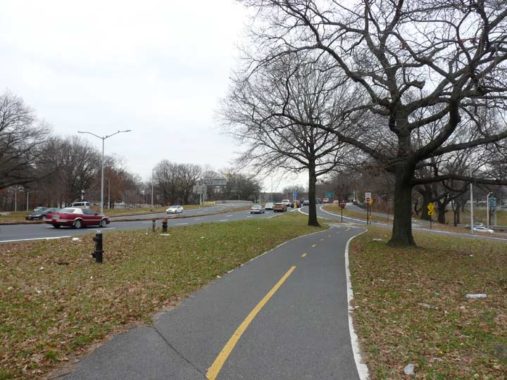
East of Amtrak, Pelham Parkway encounters a series of spaghetti roads that connect it to both the Hutchinson River Parkway and New England Thruway. The parkway itself becomes Shore Road, running on the east end of Pelham Bay Park into Westchester County. This area is also interspersed with a number of bicycle paths that run north and east; for Bronx bicyclists, it’s a golden age.


At the Hutch and Continental Avenue, in the small Bronx neighborhood called Pelham Bay, adjoining the park, I found a mystery. It appears to be a parking lot that hasn’t been used for some time. However, the DOT lights it, there is the leaf symbol of NYC Parks, and “no trespassing” signs. (I trespassed; if you want to ticket me, I’m here.) My guess is that it’s a parking lot for Parks personnel.


It’s dueling Art Deco apartment buildings at St. Paul Avenue and East 196th Street. I can’t decide which one I like better. Other than exceptions like East 222nd and 233rd, which extend several miles deep into eastern Bronx, East 194th through East 197th in Pelham Bay are the easternmost numbered streets in the borough.
St. Paul Avenue isn’t named for the Biblical apostle — a Paul family owned the land in the colonial area.

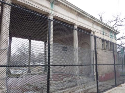
This former public restroom can be found at Westchester Avenue and Bruckner Boulevard just west of Pelham Bay Park at the eastern end of the #6 train. It has now been fenced off, so perhaps some criminal activity was going on there.
From here I got the bus back to Flushing. An express bus runs twice an hour on the weekends, and one was just pulling in when I got to the stop. This was too good a coincidence to not take advantage.
Check out the ForgottenBook, take a look at the gift shop, and as always, “comment…as you see fit.”
1/27/19