
I’ve always thought that New York City should maximize its transit options. There are still miles upon miles of (mostly) intact railroad right-of-way that could be restored to revenue-based transit whether it be as part of a subway or commuter railroad. New York City pulled off a master stroke in 1940 when it acquired the old right-of-way of the New York, Westchester and Boston Railroad, constructed in the 1910s, in the northern Bronx and converted it to a branch of the IRT. (I walked along its complete route back in 2012.)
A few years earlier, NYC missed the boat, in my opinion, when it turned down the Long Island Rail Road’s offer to sell its Whitestone Branch to the city in 1932. The city could have taken the moribund railroad and converted it to modern subway branch connected to the Flushing Line, today’s #7 train. Other borough-based transit such as the Long Island RR Bay Ridge Branch and Evergreen (Ridgewood) branches had discontinued passenger service by the mid-1920s.
However, added rail should not be redundant, it should be in underserved areas. The city’s proposed BQX light rail is supposed to connect the communities of Red Hook and northern Astoria, running generally along waterfront areas. With the exception of Red Hook, though, most of the communities it would serve are adequately covered by existing subway and bus routes (though part of me would like to see a trolley return to NYC, as many other larger cities feature light rail. The closest line to NYC is Hudson-Bergen Light Rail and the Newark Light Rail, originally City Subway.)
The Long Island Railroad’s Rockaway Beach Branch diverged from the LIRR’s Main Line in Rego Park at about 66th Ave. at what was called Whitepot Junction. It ran south through the neighborhoods of Middle Village, Woodhaven, Ozone Park, Howard Beach, across Jamaica Bay and through Broad Channel, and on to the Rockaway Peninsula, where one spur continued east and rejoined the LIRR in Far Rockaway, and the other went west and dead-ended at Beach 116th St. at the Rockaway Park station. The LIRR discontinued service across Jamaica Bay in 1950 after a fire, and then ended service between Rego Park and Ozone Park in 1962. The Transit Authority stepped in and restored the Jamaica Bay connection in 1956, connecting the peninsula to the Liberty Avenue el, but the rest of the line has been allowed to deteriorate in place.
For the past couple of decades, two proposals have arisen to deal with that remaining right-of-way. The Queensway proposal would convert it to a linear park in the same way that the old West Side Freight Railway became High Line Park; similar conversions have been done in Philadelphia and Chicago. A second proposal (that I lean toward) would rebuild the rails and connect them to the IND Queens Boulevard Line, with a new subway line connecting the IND Rockaway connection at Liberty Avenue to Queens Boulevard or a new LIRR line connecting Atlantic Avenue with the main branch. Both would require a massive outlay in funds and support from local communities. Neither will happen and I predict nothing will happen along the old railroad branch anytime soon.
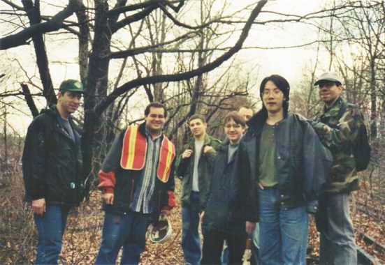
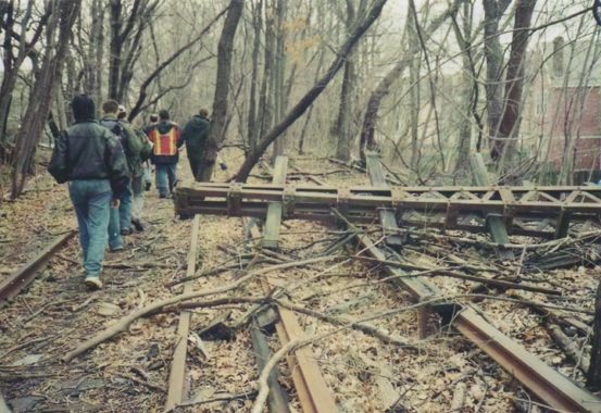
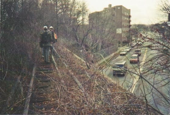
Back in March 2000 I set out with a band of urban explorers that walked the old LIRR Rockaway Branch from Rego Park to Woodhaven. The group included the late photographer and urban chronicler Bernard Ente (left); the MTA’s Mark Wolodarsky (reflector jacket) and my friend Vincent Losinno (right). I recently rescanned the pictures I took that day, and will insert them in appropriate spots in this post. Mark had previously led us into the abandoned Ninth Avenue El tunnel that connected the el in Manhattan under a hilly area in the western Bronx with the Jerome Avenue El.
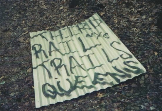
We found that some other Arne Saknussemms had preceded us.
Walking Rego Park
In February 2019, I decided to recreate the route, not by walking the trackway again (for the most part, the MTA has put in new fencing that completely restricts access to the tracks except in Forest Park, a section I’ll illiustrate later in this series). I decided to parallel the branch using local streets as best I could. This led me to make some new discoveries as well as revisit some places in Rego Park, Glendale, Forest Park and Woodhaven.
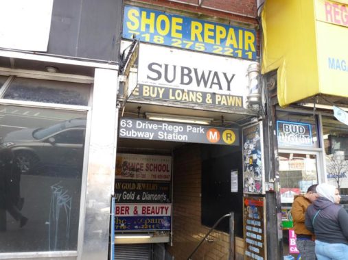
Then as now the closest subway station to the Rockaway Branch is 63rd Drive on the Queens Boulevard line, serving local E and M trains (back in 2000, R, G and V trains made this stop). I found the same cluttered signage groupings that I had encountered here back in 2000.
GOOGLE MAP: ROCKAWAY LIRR BRANCH

Our Savior Lutheran Church at 63rd Drive and Wetherole Street, an institution that has been in existence for almost 80 years. Services are conducted in English and Chinese, reflecting the diversity of modern-day Rego Park. The building was constructed in 1931 but appears to be rather older.
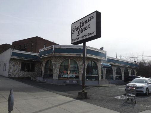
Shalimar Diner, built in 1972 after the “Rego Park Inferno” destroyed a row of stores and the Rego Park branch of the public library which was subsequently rebuilt. The Shalimar closed in late 2018. Preservationist Mike Pearlman made arrangements with the site’s developers to offer the diner for free to anyone who will pay for its relocation. As of May 2019 no progress has been made on that front.
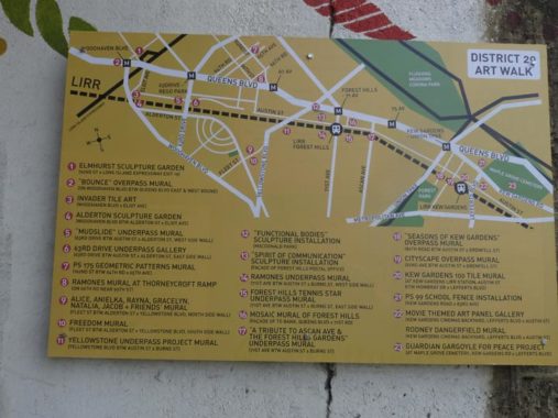
The Long Island Rail Road main branch cuts through western Queens, paralleling Queens Boulevard separated by a couple of blocks. Several streets and avenues cross under the LIRR, and NYPD Transit District 20 is tasked with keeping these areas safe. It’s not completely clear on the sign, but the NYPD is probably sponsoring the various artworks that have appeared on the walls under these crossovers, and this handy map shows where they are in Rego Park and Forest Hills.
Just east of 63rd Drive, the Rockaway Branch diverged from the main line with northbound Rockaway tracks joining the main branch using this concrete tunnel. The connection was known as the “Whitepot Underjump.” The word has nothing to do with light-colored kitchenware but goes back to a colonial-era settlement called Whitput, the “put” deriving from a Dutch term meaning “brook.” Horse Brook and other streams coursed through Newtown before they were rerouted into the NYC sewer system.
no images were found
Alderton Street parallels the LIRR main branch for a few blocks, but then curves south along the Rockaway Branch. It’s dominated with attached homes with trim front gardens (some have been concreted over).
In the 1920s, the Real Good Construction Company bought up the land and carved out a grid of crescent shaped streets. Along these they built more than 500 Tudor-style one-family attached and detached homes. In 1923, Rego Park was named as such by its developers; Rego being simply the contraction of “Real” and “Good.” The Rego Park of today fills a triangular piece of land bordered by three major Boulevards: Queens, Woodhaven and Yellowstone. All three are major commercial strips as well as homes to large apartment complexes.
no images were found
Rego Park features a street layout found nowhere else in New York City. Semi-circular streets were laid out and given aristocratic-sounding alphabetized names from A through F: Asquith, Boelsen, Cromwell, Dieterle, Elwell and Fitchett. These streets, known collectively as “The Crescents,” feature detached housing of varying quality. All the Crescent streets begin and end at Alderton Street.
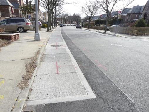
This is also a feature I find nowhere else in New York City, a separate road pavement along the curbs on either side. If someone knows what this is all about, let me know in Comments.
Forgotten Fan Patrick O'Connor:

It is meant to infiltrate storm water into the ground before it gets into the sewer system.  You can test it yourself by pouring water on it and watch the water disappear rapidly.  This results in improved water quality as there is less overflow from combined sewers during heavy rain events.  It performs a similar function to the rain gardens or bioswales that you may have noticed popping up in Queens, Brooklyn and the Bronx.

These are DEP initiated projects done in conjunction with DOT and Parks.  There were also a couple of areas that were installed by DOT in south east Queens some while ago.  One is somewhere on Linden Boulevard and the other by Springfield Lake, on the median on Springfield Boulevard.
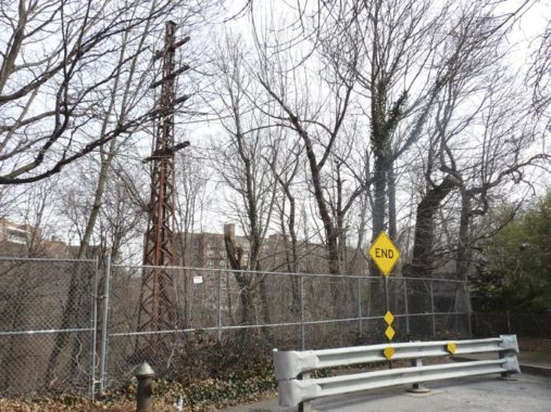
In 2000, our group used this stub end of 64th Road off Alderton to get at the tracks. As you can see, the city has more adequately protected access to the tracks since then. You can see one of the iron towers that carried electric power lines along the trackway.
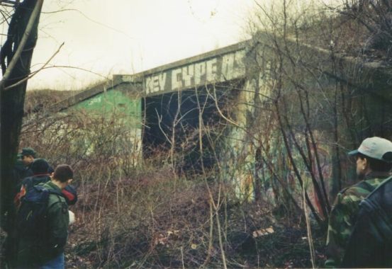
Some of these towers had collapsed as we made our way south along the trackway in March 2000.
no images were found
We found several railway signal towers along the tracks.
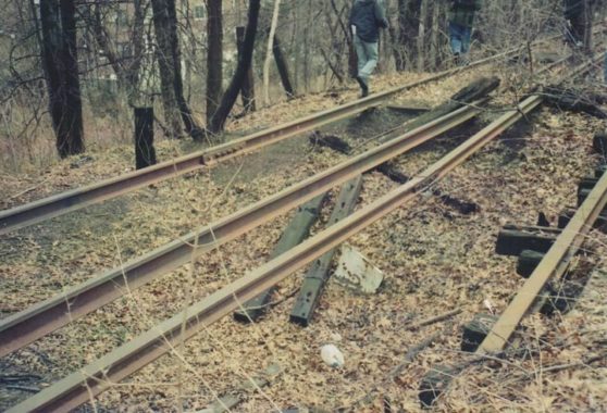
In some cases the ground was completely washed out, leaving only the tracks in place. No trace of ballast.
no images were found
Another stub, Dartmouth Street, meets Alderton Street between Cromwell and Dieterle Crescents. This is the only street other than Fleet in Forest Hills’ alphabetical street pattern that enters Rego Park. Older maps show it spanning the trackway, but I’m not sure that it ever did. Someone has placed an unusual lookout tower in their backyard here.
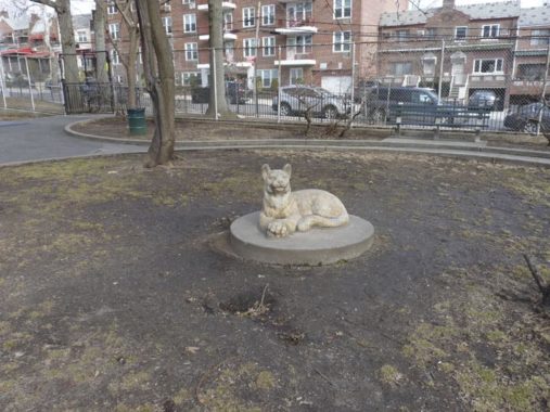
Painters’ Park is a playground at Alderton Street and the southern loop of Dieterle Crescent. I’m not sure what painters former NYC Parks Commissioner Henry Stern had in mind when naming it: house painters, the Old Masters, or Salvador or Jack the Dripper. In any case, the park provided a rest room break for those on the April 2019 FNY Rego Park tour.
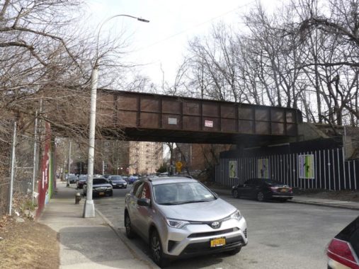
This iron railroad bridge takes the Rockaway Branch over Fleet Street, another of Forest Hills’ group of alphabetical streets that begin with Austin and run up to Olcott. Why was Fleet street allowed to pass? Perhaps because it’s part of a very old route that predates Rego Park, the Crescents, or any other 20th Cntury street layout.
no images were found
In 1909, the main roads through at the time were Whitepot Road, Trotting Course Lane (now Woodhaven Boulevard), Remsen’s Lane (seen at the NW edge of the map) and Hoffman Boulevard (to the north of the LIRR); it is now Queens Blvd. Whitepot Road is gone, although its path can be traced along four streets: 66th Avenue, Fleet Street, Dane Place, and Yellowstone Boulevard (named by an early-20th century realtor; its derivation is unclear).
no images were found
The Rockaway Branch forms an undefended barrier between Rego Park and Forest Hills, as some local artists make aware on the underpass walls. There’s also a very good map of the Crescents street layout.
no images were found
On the opposite side of Fleet Street I noticed these works that I originally thought were trompes l’oeil to look 3-D, but they actually are 3-D, with raised sections. I hope the neighborhood youth leaves them alone for awhile.
no images were found
This is what the Fleet Street overpass looks like topside, as our group fought through the weeds.
no images were found
An iron bridge also carries the Rockaway Branch over Yellowstone Boulevard. I made a detour on Groton Street and down the boulevard checking out some things, including the Project Eden community garden on Kessel Street:
The landscaped enclave, which was founded in 1992 after being acquired by the Parks Department, is the result of a partnership of local volunteers who set an example for their community and the planet.
What was once a trash-infested lot filled with tar deposits and boulders alongside the old LIRR Rockaway Beach Branch Line, is now home to diverse plants, vegetables and herbs.
It is an attraction for wildlife, community events, and a place to sit and unwind. It has indeed become Forest Hills’ own “Garden of Eden.” [Mike Pearlman, Forest Hills-Rego Park Times]
no images were found
The Yellowstone Boulevard trestle is much more massive than the Fleet Street bridge. I also find it interesting because the underside is lit by 1970s-vintage original version sodium pendants.
In 2000 our group found the Yellowstone Boulevard trestle a bit difficult to maneuver because the tracks run on the outside of the trestle with no railings: since only track workers were supposed to be up there no railings were ever installed. If anyone tripped on the weeds, he would have found himself on Yellowstone Boulevard with injuries facing down rushing traffic. Look how close the southbound track is to the edge!
no images were found
Here Yellowstone Boulevard and Alderton Street encounter multi-laned, pedal to the metal Woodhaven Boulevard which since 1925 has been speeding traffic from Queens Boulevard south across Jamaica Bay to the Rockaway peninsula. You might say that one of the reasons the LIRR Rockaway Branch went out of business is Woodhaven Boulevard itself, which emphasized the primacy of roads over rails beginning in the first half of the 20th Century.
West of here is St. John’s Cemetery and the community of Glendale.
A triangle formed by Woodhaven Boulevard, Polo Place and Trotting Course Lane (which I will discuss shortly) is Nat Schenider Triangle, which is highlighted with hitching posts with horses’ heads, in honor of a local personality (1896-1969) a set designer for Ziegfeld Studios, president of a local bus company, State Assembly candidate, president of several civic organizations, WWI vet and American Legion commander.
Nat didn’t have anything to do with horse racing or polo but the confluence of Polo Place and Trotting Course Lane, which were given those names over century ago, is a convenient spot to decorate a small park with hitching posts.
Trotting Course Lane issues south from Woodhaven Boulevard at Polo Place. It runs for a few blocks, and then resumes again near the Jackie Robinson Parkway. I find it fascinating because it’s the original road that evolved into Woodhaven Boulevard. I give its story on this FNY page.
no images were found
I usually don’t create Galleries this large but I did want to squeeze in as many photos of the colonial-era Remsen Cemetery, at Trotting Course Lane and Alderton Street, as I could. Queens is dotted with small cemeteries — some preserved like this one, some paved over, some just weedy expanses with no tombstones.
Remsen Cemetery contains eight burials from 1790-1818. A historical plaque identifies Colonel Jeromus Remsen (1735-1790), who served in one of the major Revolutionary War chapters, the Battle of Long Island.
The Hempstead Swamp once occupied a vast area of land that sits just east of present-day St. John’s Cemetery in Queens. The greater area was first settled in 1653 as ‘Whitepot’ by English and Dutch farmers, including the Remsen, Furman, Springsteen and Morrell families. They found the land good for growing hay, straw, rye, corn, oats and various vegetables. During colonial times, there were only a few roads that cut through the marsh. One of these was Whitepot Road, known as Yellowstone Boulevard today.
The other was Remsen’s Lane, a road which became 63rd Drive and 64th Road. The Remsen family lived along the road, and their burial ground, which includes the resting place of Revolutionary War veteran Colonel Jacobus Remsen, is still intact here.
Near the cemetery stood a school called the Whitepot School, built by the founding families, which served the area into the early 19th century. [Christina Wilkinson, from FNY’s Rego Park page]
Why did this small cemetery survive when so many others in Queens were bulldozed? An American Legion post, the one that Nat Schneider commanded, stood here and made sure it was preserved, and it was finally designated by the NYC Landmarks Preservation Commission in 1981.
We’re about ready to cross into Forest Park and Woodhaven, and we’ll do that in Part 2.
Check out the ForgottenBook, take a look at the gift shop, and as always, “comment…as you see fit.”
5/26/19
13 comments
I think Alderton got permeable pavement from the city bioswale project.
http://www.arcgis.com/home/webmap/viewer.html?webmap=a3763a30d4ae459199dd01d4521d9939&extent=-74.3899,40.497,-73.3757,40.9523
That “separate road pavement along the curbs on either side” of Alderton that you mentioned in one of your photos above is only about a year or two old. I drive Alderton regularly and wondered how the residents put up with having no access to their own driveways during the construction. I believe it is utility-related.
Following the ROW from Rego Park on the map link below, it seems to have been taken over by MTA at Aquaduct. Is that what has actually happened?
https://goo.gl/maps/ENfv9u6Y7hbwPGDp7
In 1956 NYC took over the route south of the Liberty Avenue El and constructed a ramp that would take subway cars across Jamaica Bay. The Transit Authority rebuilt the bridge that had burned in 1950. The TA also ran subway cars on the elevated trestles on the peninsula that had formerly hosted LIRR trains.
The elevated trestles were constructed by the LIRR in 1942. A branch of the IND “A” line still runs to Far Rockaway to this day (the other branch runs to Lefferts Boulevard, the original “A” line terminal). The current Far Rockaway terminal station now used by the MTA is the original LIRR station at this location. Before the takeover by the TA, the LIRR line crossed Mott Avenue on a steel bridge, and the line descended gently to street level as it passed into Nassau County. Before the takeover by the TA, the stop after Far Rockaway was Inwood. After the TA takeover, the LIRR dismantled the bridge over Mott Avenue and dismantled the line to the point where it reached ground level. At that point, a new Far Rockaway station was constructed for the LIRR Far Rockaway line use, which is still in use today. Until the work at the original Far Rockaway station at Mott Avenue was completed, TA trains to Far Rockaway terminated at the previous station, which is Beach 25th Street.
I mean to say that the current Far Rockaway station now used by the MTA at Mott Avenue was constructed by the LIRR as part of the trestle elevation project of the 1940’s. There had been a very large, street level Far Rockaway LIRR station at that location before the trestle was built.
First of all, I think you meant to say restrict access, not resist access, because that didn’t make any sense. Getting back to this, I feel that the former Rockaway Line is just to long and important to made redesigned as just being a park. In all honesty, I think that restoring train service would make more sense especially since that line had actual passenger service unlike the High Line that just did freight and wasn’t that much anyway. Unfortunately, knowing the MTA and how they handle things lately, we most likely won’t see any restored service on that line at anytime.
Painters Park most likely gets its moniker from the adjacent William Sidney Mount public school. Mount was a mid-1800’s artist, part of the famous Hudson River School.
Google Street View has a very recent (May 2019) spot photo by Michael Bruni that is located right in the middle of the old right of way. No idea how he managed to get there.
In 1933, when the IND Queens Blvd. subway was still under construction between Roosevelt Avenue and Union Turnpike, provision was made in the tunnel, east (operationally north) of the 63rd Drive Station, for a turnout to connect with the LIRR Rockaway Beach Line. This connection never happened, of course, but provision for it is still there, underground.
I wrote a guest article in the NY Daily News, November 2, 2014, entitled “Abandoned LIRR tracks in Queens could be converted into both a new subway spur and a walking-cycling trail “. In the article I suggested that it is feasible to convert the old LIRR r.o.w. for both transit and recreational use, if done properly. Here’s the online link to my article:
http://www.nydailynews.com/new-york/queens/andrew-sparberg-new-queens-subway-greenway-article-1.1995174
The Crescents all begin and end at Alderton Street, but at different points of Alderton Street. They aren’t cul-de-sacs that have just one road for ingress and egress. They are arc-shaped streets (hence the name Crescents). That means each of the Crescent streets have two intersections with Alderton Street. I wonder if that exists anywhere else in the city.
Kevin, Your mention of Real Good Construction got me to thinking about other developments. My old neighborhood (Hollis/QV) had many Tudor style homes that look just like Rego Park.
Is there any online source that you are aware of that explores what developers built what in Queens?
“Painters’ Park”, with a cougar statue, is a clever play on words– “painter” is a regional dialect version of “panther.”
I used to go to school on the East side of the line, on Thornton and Clyde. Our school had metal stairs in the back that allowed us to walk down to the tracks. It was a special treat (and a free field trip) for classes that behaved well, that they would get to go down to “The Fields” (as we called them) and either play on the abandoned baseball fields or explore the woods. This would have been from 1990-1998, when the school shut down (though the school was much older than that) and became a Hassidic school.