I grew up in Bay Ridge, in which 86th Street, along with 3rd and 5th Avenues, was the main shopping drag. To get to Shore Road, we took the B16 bus along its western end, and to get to Coney Island, we took the B64 which ran along 86th Street in Dyker Heights as far as 14th Avenue. The B1 bus, in those days, has mostly supplanted the B64 but in my Bay Ridge era, the B1 ran along 86th under the elevated train between 18th Avenue and Stillwell Avenue. Thus, I’m well familiar with this broad street — one of the few numbered “streets” in western Brooklyn that’s 100 feet wide. It was designated for prominence from the start: this 1873 map shows it already laid out, waiting for its brother numbered streets to appear.
86th Street is so lengthy, in fact, that it leaves the town of New Utrecht’s system of numbered streets and avenues, a southern extension of the former City of Brooklyn’s, and invades Gravesend’s grid. If you’re unsure of what I’m talking about, take a look at a map of Brooklyn. In the southwest end, there’s a sequence of streets running roughly left to right, starting at 1st Street in Park Slope and continuing southwest until 101st Street is reached near the Narrows. At the same time, there are numbered avenues beginning at 3rd and continuing southeast to 28th Avenue. (There had been a 1st and 2nd Avenues, but shortly after 1900 they were renamed Colonial Road and Ridge Boulevard at the behest of real estate developers who wanted them to sound more sophisticated.)
House numbering along these western Brooklyn numbered streets follows convention. For example, between 5th and 6th Avenues, 86th Street features house numbered in the 500s, with odd numbers on the north side, and even numbers on the south side. This holds true throughout the city wherever there are numbered streets, although in Park Slope and Midwood, the house numbering can lag the street numbering a bit. And, one inviolable rule is that the house numbering, and street numbering as well, follows a cardinal, or counting number sequence, starting with a lower number and continuing on to a higher number: thus, 1, 2, 3, 4 and so on. Of course, there are skipped house numbers, as well as skipped street numbers, but the sequence is always a higher number following a lower number.
When 86th Street invades the former town, and now neighborhood, of Gravesend, it exits the western Brooklyn set of numbered avenues east of 25th Avenue. However, like other streets that do this, like 18th Avenue and Fort Hamilton Parkway, it continues to follow the prevailing house number sequence, and thus, its house numbers continue into the 2600s through the 2900s — usually in a cardinal sequence.
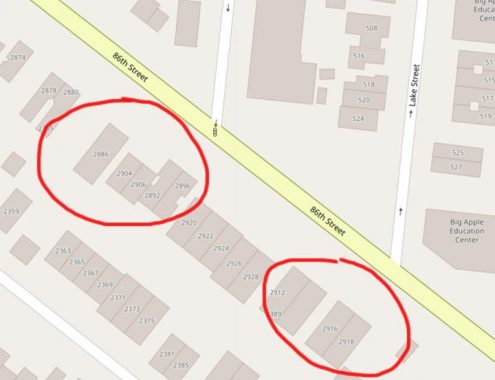
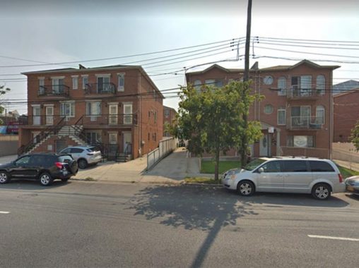
However, Forgotten Fan Allan Rosen points out an unusual exception to the rule. There are a pair of multifamily houses on 86th Street and Lake Street, just west of its terminal at McDonald Avenue, that have retrograde house numbers. That is to say, their house numbering goes “backwards.” After the pair of townhouses numbered 2930 and 2934 86th Street, the next pair of townhouses going east are numbered 2916 and 2918!

As a matter of fact, a look at Open Street Map, a great resource, indicates another similar anomaly a bit to the west, at which 2886 86th Street is followed by a townhouse numbered 2904 and 2906, which is followed by 2892-2896 86th!
Now, these anomalies are relatively new. The “misnumbered” townhouses seem to be no older than the 2000s, and the Municipal Archives photos of 86th Street from 1940 show a normal sequence. My question is, are these misnumbered houses purely mistakes and if so, how did the city let this get past them? Or, is there a different explanation?
Check out the ForgottenBook, take a look at the gift shop, and as always, “comment…as you see fit.”
10/4/19
