

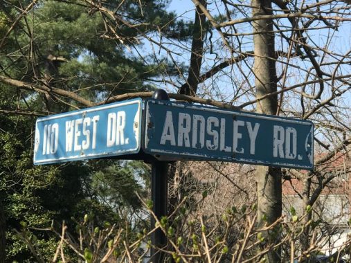


I found this sign on the Douglaston peninsula recently, at West Drive and Ardsley Road. It was hiding behind a hedge, but I have a feeling it’s been there for some time. I was wondering if this was indeed a standard issue street sign from the old days, since replaced by the standard pole-mounted signs, but the address, #110, on the West Drive sign seems to indicate that the property owner had them installed. Douglaston addresses now use the standard Queens hyphenated numbered address, i.e. 37-01, 37-02, etc.

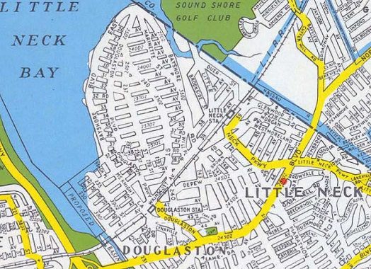
The city has been undecided over the years about how to name the streets of Douglaston. The British sounding names of today were the original ones when the community was laid out in the late 1800s, but in the mid-20th Century the city wanted to include the peninsula in its numbered grid system, so maps were made with numbered avenues and streets. I’m not sure if the numbers ever “took.” On this map, West Drive is Douglaston Parkway and Ardsley Drive is 235th Street. The old names were put back on the maps in the 1970s.
I do know that the streets in Douglaston Hill, which on this map are the streets just east of the yellowed part of Douglaston Parkway, were numbered until about a decade ago, when these streets, too, received the original names such as Poplar, Orient, Cherry, that they had when first laid out.
Meanwhile, most of Little Neck’s numbered streets were laid out after Queens streets had begun to be assigned numbers, so they never had names. So, they’ll stick with their numbers.
Check out the ForgottenBook, take a look at the gift shop, and as always, “comment…as you see fit.” I earn a small payment when you click on any ad on the site.
4/13/21