

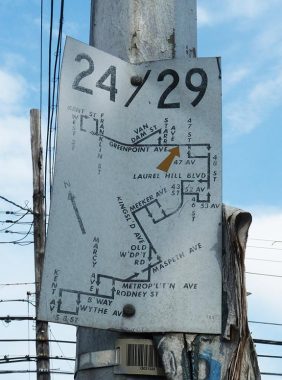


Here’s a small bus route sign at Greenpoint and Gale Avenues in Blissville, at the entrance to Calvary Cemetery. Today, bus route maps are somewhat larger and are mounted on oblong boxes mounted on poles. (The boxes also used to contain the schedules, which are today obtainable only from an app, which I believe is ridiculous, but I will avoid my inclination to rant).
These small maps were mounted in the 1960s, but you can still find a handful of these around town in out-of-the-way areas, under elevated trains, places like that. Many of the 1960s routes are the same as today, but not the ones shown here. The Q24 still runs from Greenpoint into Sunnyside and then back to Williamsburg, and while the Q24 still takes this route, roughly speaking, the Q29 is now a short route connecting the #7 82nd Street station at Roosevelt Avenue with Queens Center at Queens and Woodhaven Boulevards, then south to Myrtle Avenue and 80th Street.
As always, “comment…as you see fit.” I earn a small payment when you click on any ad on the site.
4/27/21