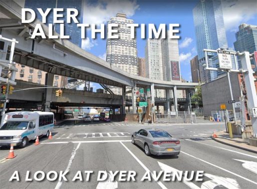
DYER Avenue is an unlikely candidate for a Forgotten New York item, as it’s one of the most car-trafficked roads in New York City. Indeed it’s nearly impossible to walk along the road as its sidewalks are just one or two feet wide. It’s even impossible to drive straight along its entire length. Its existence is tied in with the Lincoln Tunnel, as it was built along with the opening of the tunnel in 1937, necessitating the condemnation of a number of properties between West 30th and 42nd Streets between 9th and 10th Avenues. Dyer Avenue is the only major named avenue west of Park Madison Avenue between 14th and 59th Streets, though Hudson Boulevards East and West, short streets in the Hudson Yards area, were added in 2015.

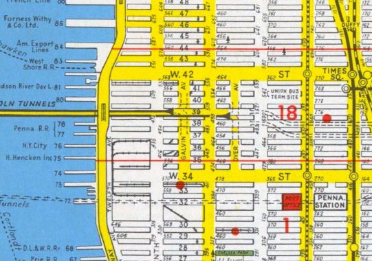
Despite Dyer Avenue’s inhospitable nature (even I stay away from the West 40s around 10th Avenue because crossing those big traffic streets is a daunting task for pedestrians) there’s some history here. First, let’s look at the map some years after Dyer Avenue was built. As you can see it was never a through street and was meant to funnel traffic from the eastbound Lincoln Tunnel tube. From the map, I’m not sure how exactly the traffic flowed here. (The Tunnel has added extra tubes, in 1945 and 1957, necessitating a transmogrification of Dyer Avenue, but I’ll get to that).
On this page, given Dyer Avenue’s near-impossibility to walk, I’ll use mostly screencaps from Google Street View, hence the tags that GSV lards onto their views.
On this map, Dyer Avenue has a partner, Galvin Avenue. Most of it was never built, but I’ll get to the small section that was. Also notice the “Union Bus Terminal” at 9th Avenue and West 42nd, the location of today’s Port Authority Bus Terminal. The bus depot didn’t open until 1950; in 1949, mapmakers were still using its working name, Union Bus Terminal. Long derided as inadequate and inhospitable, the Port Authority announced plans to reconstruct it in 2021.
The origins of Dyer Avenue’s name have been disagreed about in print. First, the wrong origin. Henry Moscow’s 1978 The Street Book is an invaluable resource, but he’s occasionally wrong. Moscow says it was named for William Dyre, NYC mayor in 1680, customs collector and one time owner of Ellis Island. In fact, Dyre was unpopular because of the taxes and import duties he levied. I’m unsure why Moscow thought this Dyre was the guy.
Meanwhile, Sanna Feirstein seems to have the right idea in Naming New York, from 2000. She argues that Major General George Rathbone Dyer was the guy. As chairman of the board of the Port Authority of New York and New Jersey, he approved the creation of the Holland and Lincoln Tunnels and passed away while the latter was under construction. Feirstein does err, though; she called it “Dyer Street.”
Don’t be too disappointed about William Dyre, though. He has his own avenue. In fact I have a nearly irresistible urge to type “Dyre” in this piece because it’s familiar to #5 train riders as the station at the end of the line, way up in Baychester near the city line. The Bronx has a whole block of avenues named for colonial-era mayors, and Dyre is one of them.
Dyer Avenue’s southern end at West 30th, across the street from the Manhattan West high rise.
The builders of Manhattan West were generous enough to vouchsafe an external walkway around their towers; there is an interior sitting section with restaurants that have yet to open and a flock of fake lemon trees. (How many of the shops and restaurants open anytime soon depend on the mercies of the Covid Pandemic.) Here. I was able to get a shot of Dyer Avenue which is still a modest 4-lane surface road between West 30th and 31st Streets.
In the background we see the Morgan General Mail Facility, which replaced the Farley Building, now the Moynihan Trail Hall, as the major mail processing center in Manhattan.
North of West 31st Street Dyer Avenue undergoes a change, as it runs through a section of the Hudson Yards project under construction as the Penn Station trainyards are being decked over; these sheds will likely be there a few years.
This 2021 map gives you a good idea of Dyre Avenue’s complicated layout. The wide purple band is a de facto expressway (Open Street Map calls it the Lincoln Tunnel Expressway) that was built in the 1960s after extra Lincoln Tunnel tubes were added, and it interacts with Dyre Avenue along the way, as well as eliminated portions of it between West 31st and 34th and between West 36th and 40th Streets.
If you look at the 1949 map at the top of the page the original southern end of Dyer Avenue was West 34th Street. Here we see it. Notice the dark brickwork on each side. It matches the original wall brick treatments on either side of the Lincoln Tunnel Manhattan approaches at West 39th Street.
Partially seen on the right is The Webster Apartments, one of the few, if not the only, affordable residences in Manhattan exclusively for women. The story behind the apartments begins in 1902 when Macy’s moved uptown from West 14th and 6th 20 blocks north to Herald Square. Macy’s cousins, Josiah and Charles Webster, were partners in R.H. Macy and noticed the many single women working as clerks and helpers at the giant store whose incomes were nonetheless minimal. The brothers decided to set up affordable housing to assist such women, but the plans came together slowly and the new Webster Apartments did not open until November 15, 1923, and its mission remains unchanged till this day. Daytonian in Manhattan has the complete story and vintage photos.
Dyer Avenue has its own cylindrical lamppost deigns, likely installed in the 1950s or 60s, with lamps set atop brick “chimneys.” I’d love to get a look at the original lamp designs from the 1930s, if the Queens Midtown tunnel lamps on the east side are any example.
Looking south on Dyre Avenue from West 36th Street. The buildings at right are in Hudson Yards, including the city’s highest observation deck, Edge, which has nothing to do with the U2 guitarist or the wrestler. That’ll be $36, $53 with champagne.
West 37th Street is bridged over the Lincoln Tunnel Expressway.
After the expressway turns west to enter the Lincoln Tunnel, Dyer Avenue is “reborn” at West 40th, where spaghetti ramps can be seen that connect the tunnel to the Port Authority Bus Terminal; only buses use them.
Of note are these bus ramp-specific streetlights that were installed just a few years ago (as of 2021).
The north end of Dyer Avenue at West 42nd street, Flanking it are two relatively new buildings, #420 west 42nd and the MiMA (for Midtown Manhattan) Apartments, built from 2007-2010.
The erstwhile Dyre Avenue running buddy, Galvin Avenue, remained relatively unbuilt. A shortened version of Galvin Avenue remained mapped into the 1980s. A short piece of the road was built, and runs between West 40th and 41st Streets next to St. Raphael’s Church and is usually choked with tunnel traffic as West 41st Street traffic runs south along it to get to the tunnel
Like Dyer Avenue, Galvin Avenue was built in 1937 and was named for another Port Authority chair, John F. Galvin.
As always, “comment…as you see fit.” I earn a small payment when you click on any ad on the site.
8/19/21
