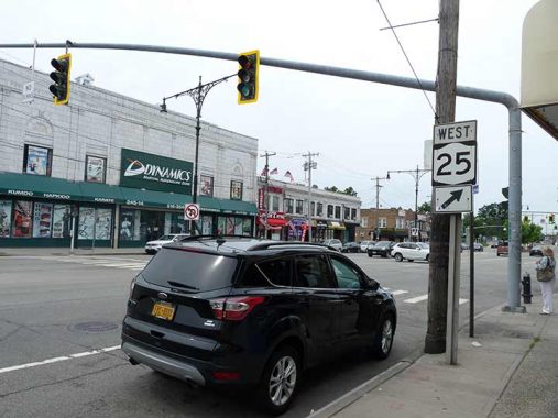
INFRASTRUCTURALLY, there’s a lot going on here at the undefended Queens-Nassau borderline where Jericho Turnpike/Jamaica Avenue encounter Braddock Avenue and the Cross Island Parkway. On the left, we see the old Bellerose Theatre, which first opened in 1926 and closed in the mid-1980s, only to become a martial arts center after spending years as a carpet store.
From the Cross Island Parkway east to 257th Street this route is known on both sides of this undefended border, to and from which all may enter and exit freely, as Jericho Turnpike, named for the small town in mid-Nassau County through which it runs. Until 1995, though, the Nassau County portion, in the municipalities of Bellerose and Floral Park, was named Jericho Turnpike and the Queens County portion on the north side of the road was named Jamaica Avenue, as the portion completely contained in Kings and Queens Counties is. Neighborhood political representatives on the Queens side petitioned for the change, ostensibly desiring a less confusing situation. But they’ll never convince me that they didn’t want an association with the neighborhood of Jamaica, Queens, several miles to the west.
Incidentally there’s a Bellerose and Floral Park in Nassau that are quite separate from the Bellerose and Floral Park in Queens. Only your postal carrier knows for sure.
Jericho Turnpike has a center median and between 10-20 years ago (as of 2021) it received a set of Twin Corvington lampposts. Twin Corvs are a recent invention. When the style first appeared in the 1910s, a Twin version was never designed; only after they were reintroduced in the 1980s did Twin versions ever appear.
You will note a Nassau County style stoplight stanchion on the right side of the picture. They have a simple design: cylinders with a bend in the middle arching over the road. They come in different lengths, with the longer variety used here. But notice that it’s placed on the Queens side of Jericho Turnpike. The Department of Transportation of NYC must have an easement agreement with its Nassau County counterpart (whose name escapes me; help me in Comments) and Nassau stoplights, pedestrian signals and even some Nassau street signs can appear on the Queens side.
Lastly, here’s a NYS Route 25 sign. The route runs over 100 miles west to east, from the Manhattan side of the Queensboro Bridge down Queens Boulevard, Hillside Avenue, Braddock Avenue, Jericho Turnpike, Middle Country Road in Suffolk, all the way to Orient Point on the north fork, where one can catch a ferry to Plum Island. New London, CT. There’s an archipelago of sorts way out east and you can jump from island to island by boat.
As always, “comment…as you see fit.” I earn a small payment when you click on any ad on the site.
12/2/21
