As readers of Forgotten New York know, I enjoy poring over old maps and seeking out ancient roads, then trying to ascertain if there are any remnants of them still to be found. I have an interesting one today. When I was a kid, street maps of Brooklyn still showed a dead end called Lotts Lane emanating from Dahill Road at 41st Street, just south of Ditmas Avenue. Riding my bicycle into the region in the Super 70s, I never saw any sign of it, but I wasn’t practiced in how to find former routes and didn’t see the clues.
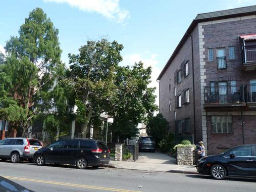
As you can see from the above image, there’s a driveway by the private home here that is on a slanted angle, unlike the other driveways that simply meet Dahill Road at a right angle. Note also the slanted north side of the adjoining building. At times, buildings take this shape because of existing property lines that follow old waterways…or old roads.

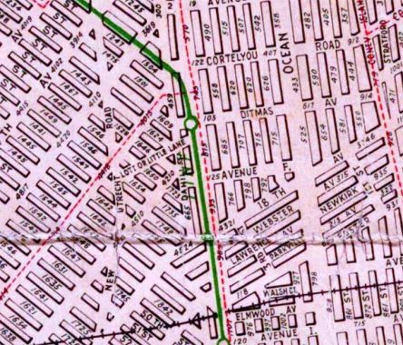
This Hagstrom Brooklyn map from 1922 shows the road as Lott or Little Lane, which emanated from a barely existing section of Old New Utrecht Road and ran on an angle, crossing Dahill Road at 41st Street. However, later Hagstrom editions placed Lotts Lane on the other side of Dahill and made it a dead end, which corresponds to that modern-day driveway. (On the map, the green line corresponds to the elevated Culver subway, which was only a few years old in 1922, and the dotted red lines were streetcar lines.)
Roads such as Old New Utrecht Road were farm to market roads that originated in the colonial era and may have followed Native American trails. As the street grid took shape and streets and homes were built, there was no further need for them and in many cases they were demapped and faded away. An exception to this rule is Kings Highway, a colonial-era road that was bulked up in the 1920s and had multiple lanes added to it at the same time that Linden Boulevard received the same treatment, at the dawn of the Robert Moses era of auto traffic.

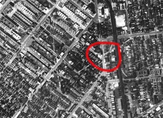
Is there photographic evidence of this trickle of a colonial era road? Sure, here it is on this 1924 aerial map. I have circled the spot where the slanted driveway off Dahill is, and you can see it shows up quite clearly. Also at left, note the narrow Old New Utrecht Road, which has two short surviving sections.
Finally, let’s strap into our HG Wells time machine and set the controls for 1873, when Lotts Lane was much lengthier and was known as Turner Harrow Lane. It ran through properties owned by Hinkley and Turner, who are still remembered today by existing short lanes on either side of Coney Island Avenue between Church Avenue and Beverly Road.
There is one remnant of this old road I haven’t talked about yet. It’s not physically tangible but if you look at a modern day map, it’s fairly obvious in the orientation of the east-west streets. The eastern section of Turner Harrow Lane corresponds to the modern Dorchester Road, which is one of a number of east-west streets from Cortelyou Road south to Foster Avenue that have this unusual slanted orientation, which perpetuates the way roads were laid out in the Town of Flatbush in the 1800s.
When you walk down these streets, you are still under the influence of area settlers in the 18th Century and previous.
As always, “comment…as you see fit.” I earn a small payment when you click on any ad on the site.
6/2/22
