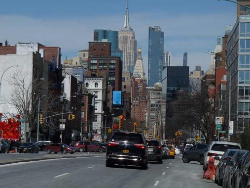

I’ll lead off today with a photo of the Bowery looking north from Stanton Street in Little Italy, because it still presents a representative look at NYC architectural styles of the 20th Century, with the King of All Buildings as a prominent backdrop. I won’t last long enough to see it but my prediction is that if current building trends continue, the Empire State Building will be invisible, as it will be surrounded and obscured by taller glass fronted residential towers. Think it can’t happen? The Bank of Manhattan, for decades the tallest building in western Queens until dwarfed by the Citigroup (now Altice) tower, One Court Square, was in second place for a few decades, but now it is utterly dominated and surrounded by towers built the past decade.
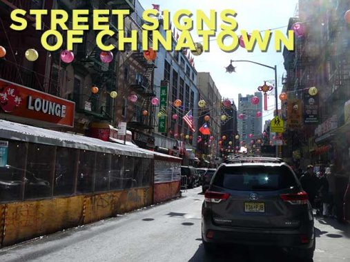
On March 13, 2022, I meandered around Chinatown for awhile before heading west to my more familiar clime in Tribeca. The shadows were harsh, as the sun was still fairly low. I was inspired by a New York Times article about the gradual disappearance that has been going on with Chinatown’s bilingual street signs. If you weren’t aware, Chinatown’s street signs have, since the 1960s, had translations, primarily in Cantonese, of area street names. Some are transliterations of what the English name is, while others are translations. There are a number of dialects in China that are so different they can be considered separate languages, and the article goes into this, as well as detailing the one man who has done the calligraphy for these signs. If you don’t have a NY Times subscription, I suggest getting one at least temporarily so you can see it. To. my regret, I don’t know a word of Chinese, despite the presence of Chinese in my family via marriage.
I don’t ascribe any hostility or an ulterior motive behind the disappearance of the bilingual signs, just nonchalance or perhaps, financial reasons. What is happening is that the newest signs don’t have the Chinese characters; the Times says Chinatown’s footprint is shrinking, but I’m not sure. As I’ve noted repeatedly in Forgotten New York, the Department of Transportation is not run with a lot of smarts as far as signage is concerned (though I have always wanted to work in its sign shop in Bedford-Stuyvesant). This is an agency that changes out perfectly readable signs for new ones but leaves illegible, sun-bleached signs in place years after they became unreadable.

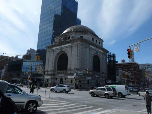
The bronze-domed Citizen’s Savings Bank building, built in 1924, the first in a procession of Bowery banks, is now a branch of HSBC (Hong Kong and Shanghai Banking Corporation), which cannot seem to adapt is signage to any of its buildings, no matter how historic.
This Beaux-Arts beauty features a bronze dome, carved stone ornamentation, arches, pilasters, scrolls, keystones, a classical entablature and a balustrade. The Bowery façade possesses a clock that is flanked by Native American and seamen figures and is topped with an eagle. [Six to Celebrate]
The lions at the Bowery entrance have two separate facial expressions, check them out. The glass-fronted object next to it is Hotel 50 Bowery, which is emblematic of modern architectural thinking. All this is across the Bowery from the Carrere and Hastings monumental arch fronting the Manhattan Bridge, which FNY toured in 2008.
The southeast corner of Canal and Elizabeth Streets. No one is sure who the original Elizabeth was — likely the wife or daughter of a landowner through whose expanse the street was laid out. Other streets in Manhattan with women’s first names are Ann, Hester and Catherine. You can’t count Jane, as it was named for a Jaynes who lived in the West Village. There was also a tiny Rachel Lane in the Lower East Side.
Private Danny Chen was a U.S. Army soldier who served during the War in Afghanistan, whose suicide resulted in a military investigation and charges against eight soldiers for bullying and personal atttacks, ultimately with four being court martialed.
On bilingual signs in Chinatown, on thoroughfares titled “Street” the final calligraphic character, bottom right, is the translation of “Street.”
In 1964, at the beginning of the Donald Deskey lamppost era, special Deskey editions were built for Chinatown that featured pendant reflectors shaped like Chinese pagodas. They gradually were grandfathered out within a decade or two, but in the 1990s, the Department of Transportation restored many of them to area lampposts. Other pieces of “street furniture” such as phone booths (when they were a thing) also had pagoda-like roofs.
A sampler of Chinatown bilingual signs. Someone who can read them let me know if these are transliterations or translations. Probably both.
The Department of Transportation also got into the act at Canal Street, displaying bilingual signs on station platforms as early as 1970. When the station was renovated in the 1990s, new mosaics appeared with characters for the words “China” and “Town” flanking the mosaic tablets.
Walker Street is a connection between Chinatown and Tribeca, running from Canal Street to West Broadway and BeachStreet. It was named for Captain Benjamin Walker, a Revolution-era soldier who served in Congress from 1801-1803. While DOT street signs are bilingual, it’s sidewalk signs and ads that truly demonstrate the two worlds of Chinatown.
Since I’m a fan of narrow alleys, I got more photos of Cortlandt Alley on this walk than anything else. the narrow passage runs for three blocks from Franklin Street and Canal between Broadway and Lafayette.
Just past Franklin, in what was once a freight elevator in a paper warehouse fronting on Broadway, is the city’s smallest and likely most unusual museum, called simply Museum. Much like Brooklyn’s City Reliquary, its mission is to display found objects and unusual collections, doing so in a cozy, welcoming, well-lit space. Exhibits have included mislabeled food containers collected by sous-chef Lulu Kalman, global toothpaste collection of industrial designer Tucker Viermeister, Polaroid photos discovered by artist Andy Spade, lost objects found on the bottom of the Pacific by deep-sea diver Mark Cunningham, and more. There are also two video screens playing works by filmmakers Richard Sandler and by the late NYC documentarian Joey Boots.
Other eclectic objects from around the globe, found by submitters, have included Russian watches, matchboxes, paperweights, nameplates from the UN General Assembly, magazines, food labels, a cap worn by someone pretending to be a surgeon in a hospital and witnessing an operation, business cards, and an assortment of weird hammers and saws.
Much more on Cortlandt Alley here.
Its name was Mudd. #77 White, on the SE corner of Cortlandt Alley, was built in 1888 for real estate developer John Dodd. Its more recent claim to fame was the presence of rock venue The Mudd Club between 1978 and 1983. Georgia band the B-52s (who are playing their final shows in 2022) made their NYC debut here, and it is memorialized in the lyrics of the Talking Heads classic “Life During Wartime.” (and also by The Ramones, Nina Hagen, and Frank Zappa, who viewed the NYC scene with bemusement). The club was named for Dr. Samuel Mudd, who treated John Wilkes Booth, who had injured himself while escaping Ford’s Theatre in Washington, DC, where he had assassinated Abraham Lincoln. The long stick he used to set Booth’s broken leg bone came to be called “Mudd’s Club.” News anchor Roger Mudd was a descendant of the doctor.
The Mudd Club was frequented by many of Manhattan’s up-and-coming cult celebrities. Individuals associated with the venue included musicians Lou Reed, Johnny Thunders, David Byrne, Debbie Harry, Arto Lindsay, John Lurie, Nico with Jim Tisdall, Lydia Lunch, X, The Cramps and The Bongos; artists Jean-Michel Basquiat and his then girlfriend Madonna and (later) Keith Haring. wikipedia
I continued west on Franklin to Finn Square, the triangle where Varick Street and West Broadway meet. It’s an interesting area with a number of artifacts, now and old, that interest me. Formerly open to traffic, the stub of Franklin Street between Varick and West Broadway has been closed since 2014 when a Citibike rack was placed in it, and the pavement has been occupied by two installations of public street art. One, “Xola (Stay in Peace)” by artist Imani Shanklin Roberts, consists of colorful patterns of geometric shapes. Since it is co-sponsored by Citibike, I imagine it was installed independently of the racks and seems to date back to 2017 (judging by Google Street View). Unfortunately, though, street repairs go on and on and half of it seems to have been paved over for the majority of its existence. See its former appearance on this FNY page.
At Varick and Leonard is the Square Diner, by far the smallest diner I have ever been in. There has been a diner in this location for decades. Above is the site in 1940 and what it looks like today, and my visit there at the end of a Tribeca ForgottenTour is pictured on this FNY page.
Finn Square actually honors two Finns. The first was a Tammany Hall politician, Daniel E. Finn (1845-1910), known as “Battery Dan” for his success as an assemblyman in the First District for helping block a plan to build piers along the west shore on Manhattan in Battery Park. The piers were not built and Battery Park remains to this day a much-needed open space relief from the beetling towers of lower Manhattan. As a judge, Finn was known for protecting the public against Police Department excesses.
Although in actuality Finn Square was named for “Battery Dan,” officially it is named for his son, Philip Schuyler Finn, a member of NY’s Fighting 69th Regiment, who perished in World War I. The square itself was created shortly after the war, when Varick Street was given a southern extension past Franklin Street to meet West Broadway.
The handsome loft building at West Broadway and Franklin, constructed of masonry, cast iron, brick with a sheet metal cornice, was completed in 1882, in a decade when I think architecture was never better.
I am unsure when the entrance kiosk for the downtown Franklin Street IRT station was placed there. Since overall station renovations were done in the 1990s, my guess is that decade.
#226 West Broadway, north of the square, is a notable 1912 building featuring a gleaming white terra cotta front. Formerly the FDNY High Pressure Service Headquarters, it was later transferred to the Dept. of Water Supply, Gas and Electricity. I am attracted to gleaming white terra cotta as if it were pizza.
This sort of letter chiseling, which is rarely done today, must have been very difficult to do. Notice the little triangles between the words, done as just an added fillip or decoration. Early mosaic subway signs from 1908-1928 feature them as well.
From the 1991 NYCLPC Historic District Designation Report:
This four-story, twenty-five-foot wide municipal office building, located midblock, was erected in 1912 for the Department of Water Supply, Gas, and Electricity as a headquarters for the repair company of the high pressure fire service system. It was designed by Augustus D. Shepard, Jr., an architect who spent much of his career working in the Adirondacks.
The building, faced in cream-colored glazed terra cotta, has characteristics of both an industrial workshop and an office building. The base has a center vehicular opening flanked by pedestrian doors. The Secessionist-inspired ornamentation of the building features one-of-a-kind forms of hydrants, pipes, and valves — the iconographic representation of the work of the agency, the name of which appears in a panel at the second story. The upper facade is almost a window wall, with grouped two-over-two-over-two triple-hung wood sash, divided into bays which correspond to the divisions of the base; iron balustrades edge shallow balconies at the fourth story.
A curved parapet frames a sculptural of the seal of the City. The western elevation has a shallow skylight-lit extension at the first story and two or three windows at each story above. The building was erected on a city-owned lot on which had stood a wing of Ward School No 44, located at 10-12 North Moore Street. In 1967 this building was occupied by the Department of Welfare Maintenance Shop; it is currently in private ownership.
Number 2 White Street, on the corner of West Broadway. Because of the miracle of landmarks preservation, the designated #2 White Street, at the northeast corner of West Broadway, has survived since 1809. It was constructed that year for a Gideon Tucker, owner of the Tucker & Ludlam plaster factory. It’s one of the few Federal Style row houses remaining in lower Manhattan. A few others that were moved from their original location during construction of Independence Plaza can be seen on Harrison Street west of Greenwich. Its former life as a liquor store is still represented by a neon sign; not sure if it lights up at night.
Above it is a painted ad for Matera Canvas, which distributed boat covers, tarpaulins, tote bags, awnings, aprons at 5 Lispenard Street, originated in 1907 and was still in business as late as 1990. The storefront used to feature a nifty clock.
According to the Indispensable Walter Grutchfield, Goodall Rubber was founded in 1906 in Philadelphia and established offices in NYC in 1911. The Finn Square office, at #5 White street, was established in the 1930s and left in the 1970s. Two painted signs must have used superior quality paint as they are still quite legible all these years later. Goodall Hose remains in business.
Much more from Finn Square here.
As always, “comment…as you see fit.” I earn a small payment when you click on any ad on the site.
11/19/22
