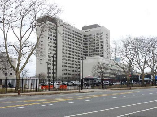
THE Brooklyn Veterans Administration Healthcare System hospital, 800 Poly Place near Fort Hamilton, has been a Bay Ridge staple for a long time, but I know little of its history, even when it was built. When I was a kid, we would bundle up used magazines and bring them down there so the soldiers in treatment, many fresh from combat in Vietnam, would have something to read while hospitalized. Years later, when I worked nights, I would come home in the early morning, crossing the Gowanus Expressway on 72nd Street or 7th Avenue. I would look south to see the big red tree in Christmas lights on the hospital in season, and knew I was home.
However, it’s the road in front of it in this photo that had always fascinated me. The paper maps I consulted, from Hagstrom, Geographia and other makes, simply showed this road, which connects 7th Avenue and Poly Place (named for Poly Prep Country Day School at 7th Avenue and 92nd Street) and Cropsey Avenue and 14th Avenue, as unnamed, with no determination of what it was called.
Things changed over a decade ago. The Department of Transportation, on its street signs, now prefers to call the two-lane street running along the south edge of Dyker Beach Golf Course as an eastern extension of Poly Place; the Veterans Hospital’s address is 800 Poly Place. The MTA, though, sticks with “Cropsey Avenue” on its bus stop signs. There was likely ambivelance because, other than the hospital, there are no addresses on the road, which brings traffic between the golf course and Dyker Beach Park.
Believe it or not, during the Easy 80s, I used to be able to bicycle through NYC’s only active military base with minimal security; I wasn’t stopped at the gate. After the Gulf War and subsequent events like 9/11, that kind of access has been impossible; I was told to not even point a camera into the base at the front entrance.
As always, “comment…as you see fit.” I earn a small payment when you click on any ad on the site.
6/13/23
