


GRAVESEND Neck Road was once a major east-west artery in Gravesend and Sheepshead Bay in the days of carts and wagons. “Neck Road” as it’s called by locals and the MTA on a Q train station, is along with Kings Highway and Flatbush Avenue one of Brooklyn’s oldest roads, having been here since the colonial era and likely built over an Indian trail. It runs from Van Sicklen Street southeast and northeast, crossing Avenue V twice and ending at Avenue U and Haring Street, though it once continued on to about Gerritsen Avenue. At its west end you will find the historic Gravesend and Van Sicklen Cemeteries as well as the now-landmarked Lady Moody House.
Gravesend is likely named for the British seacoast town, Gravesend, which derived from “end of the grove”; the less likely derivation is from the Dutch s’Gravenzande, “Count’s beach.” The “neck” Gravesend Neck Road goes to was in what’s now northern Sheepshead Bay and was likely a narrow strip, or “neck” of dry land amid marshier territory.

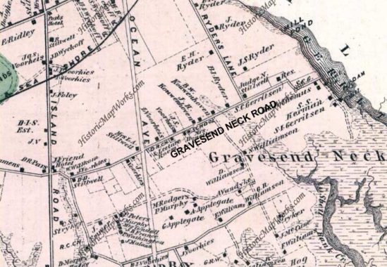
Here’s an 1873 map of Gravesend and Sheepshead Bay. Gravesend Neck Road is one of the few existing roads along with “Coney Island Road,” now Avenue. The road at the bottom is Voorhees Lane, now Jerome Avenue, while Ocean Avenue was planned but not yet built. Ryders Lane, which cut diagonally across the area, has left little trace. The small squares represent houses and their owners. Each likely sat on a small plot of land that was farmed. Names such as Ryder, Voorhees, Gerritsen, Stillwell and Applegate can still be found on street maps.
As always, “comment…as you see fit.” I earn a small payment when you click on any ad on the site.