ANCIENT New Utrecht, Brooklyn, now co-terminous with Kings County, was once just one of six towns that made up Kings County, delineated by British rulers in 1683. “Kings” refers to the Restoration British monarch at the time, King Charles II.
The history of Brooklyn’s towns is complicated… but the $2 history is: The county’s original towns were Brooklyn (today’s downtown and stretching east and south as far as Bedford-Stuyvesant and Sunset Park), Bushwick, Flatbush, Flatlands, Gravesend and New Utrecht (New Lots was carved out of Flatbush later), and after a series of secessions and reorganizations, Brooklyn, by then a city, managed to annex all other towns and cities in Kings County in 1896 — only to consolidate with Greater NYC in 1898.
In the Dutch colonial era (1626-1664) New Utrecht (pronounced YOU-trekt) was settled by Dutch West India Company director Cornelius Van Werckhoven; after he died unexpectedly, his successor, Jacques Cortelyou, bestowed the name Nieuw Utrecht, after Van Werckhoven’s home, Utrecht, Netherlands. The original town boundaries encompassed today’s Bay Ridge, Borough Park, and Bensonhurst.
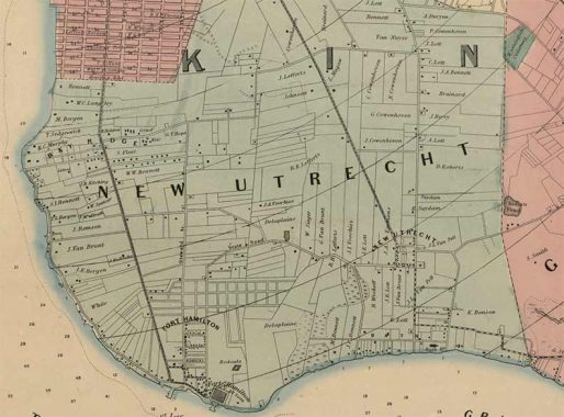
Here’s an excerpt from the invaluable Dripps map of Kings and Queens counties in 1852. I say “invaluable” because it depicts a completely different world from the ultra-urbanized, citified Brooklyn of today, in which the old town of New Utrecht is now the neighborhoods of Bay Ridge, Dyker Heights, Borough Park, and Bensonhurst. I kid a lot about an H.G. Wells time machine, but it’s the one impossible machine I wish could be built. Imagine what it would be like to dematerialize and then materialize in the New Utrecht of 1852, when the street grid did not exist and the entire area was cultivated farms and open woods, with few roads and only a few small settlements, like the heart of New Utrecht at today’s 18th Avenue and 84th Street, as well as what became Ovington Village at today’s 3rd and Ovington Avenues. And imagine what a shock it would be if those farmers and villagers of 1852 could use that same time machine to visit 2024! You can only wonder who would think they had the better of it, the 1852-ers or 2024-ers? It’s moot, as there will never be a machine that could move in time. We’re all trapped in the time we inhabit.
Looking at the map, “Bay Ridge” was a new name that at the time applied to a small area at Ovington Village. It was renamed from “Yellow Hook,” referring to the light soil, after a yellow fever epidemic. Fort Hamilton, still an active military base, was built between 1825 and 1831, fearing a foreign invasion after the War of 1812. Instead, it wound up training troops to defend domestic soil in the Civil War, or in Robert E. Lee and Stonewall Jackson’s case, to fight against it.
3rd Avenue was the first of the numbered avenues to be laid out, because it supported a horsecar line connecting the city of Brooklyn to Fort Hamilton. Within a decade, Charles Gunther would build the West End Railroad to Coney Island; it survives today as the D train. Kings Highway reached Bay Ridge via a long-obliterated section called State Road. The town line of New Utrecht and Gravesend ran along what would become today’s Bay Parkway. Washington Cemetery, founded in 1850, had not yet attained its present size.
Scattered to the winds are the descendants of the farming families of New Utrecht, descendants of Dutch settlers in the 1600s. Think about it. After over 200 years of Dutch and British occupation in which the original Native Americans were driven out, and in 1664 taken over by the British Crown, New Utrecht was still largely farms and fields. There was no electricity: moonlight and bonfires lit up the night. After 1852, though New Utrecht didn’t immediately join the city of Brooklyn and then NYC, the city of Brooklyn’s urbanity slowly spread south. The old farms were divided into neat parcels, as a street grid, imitative of Manhattan’s, would be laid out and built. Houses were constructed in neat plots along these streets. Commercial areas, schools and hospitals followed. And the New Utrecht, the Bay Ridge, I was born into in 1957, took shape.
Here’s a zoomable version of that map.
As always, “comment…as you see fit.” I earn a small payment when you click on any ad on the site. Take a look at the new JOBS link in the red toolbar at the top of the page on the desktop version, as I also get a small payment when you view a job via that link.
5/13/24
