

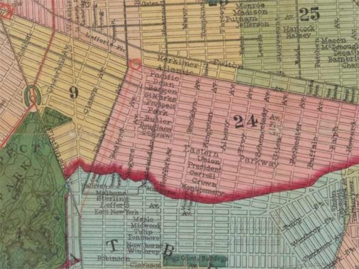


USUALLY in my Forgotten New York posts, I bring up subjects to which I already have answers (like any decent trial lawyer). Today, though, is a bit different: I have a question for any Brooklyn historians who may be reading. Today I am showing an excerpt from a McElroy, Son & Brown map of northern Kings County from 1874, at least that’s the date given by the NY Public Library map collection (you can view the whole thing here).
In 1874 Kings County was still divided into towns, many of which were drawn up shortly after the NYC area was taken over by Europeans in the mid to late 1600s. There was Brooklyn proper, Bushwick, New Utrecht, Gravesend, Flatbush, Flatlands and New Lots, a Johnny come lately carved out from the eastern parcel of Flatbush. Don’t let the marked streets fool you; at this point most existed on paper only and the southern end of Kings County was mostly rural, with scattered small hamlets.
While the dividing lines between towns was straight as a string for the most part, drawn up by surveyors whose names have been lost to history, the divider between Brooklyn and Flatbush, marked here by a red stripe, was a different matter entirely. Remember, it wasn’t drawn to conform to mapped streets, as they didn’t exist when the borderline was made. I’m perplexed by the borderlines zigzaggedness, as it’s quite uneven, roaming all over the place, this way and that. When you see a border jumping around like that it usually marks a waterway that has since been straightened; some of the Bronx-Westchester line in Wakefield is like that. No map to my knowledge shows any creek or river in Flatbush, though, except Paerdegat Creek, which was considerably south of here.
So, I’m stumped about why the line was drawn this way. The only thing I can think of is that this line was drawn along the terminal moraine, a group of east-west hills in mid-Kings County and along the so-called cemetery belt separating Brooklyn and Queens. Though parts of Brooklyn are quite hilly, the hills were more pronounced in the colonial era, and in many cases crews of men were employed to “dig down” the hills to make them shorter. That’s what may well have happened along this curious borderline.
Check out the ForgottenBook, take a look at the gift shop. As always, “comment…as you see fit.” I earn a small payment when you click on any ad on the site.
3/27/25