Broadway. Wall Street. Fifth Avenue. 42nd Street. Mention these streets and only one city comes immediately to mind: The one abbreviated in the title of this website. But in small town USA, including most New York City suburbs, most town centers sprung up around a street called Main. Well, New York City has Main Streets too…in fact, it has five, one per borough. And all have tales to tell about their neighborhood’s history and growth. Let’s exile ourselves, at least temporarily…on Main Street, NYC.
Flushing, Queens
Flushing is a community located about centrally in the northern section of Queens, east of the Van Wyck Expressway and west of Bayside. It is one of Long Island’s, and New York City’s, oldest settled towns, with a history stretching back to the early 1600s. Flushing is also home to New York City’s longest, and commercially most potent, Main Streets.

Today, Main Street in Queens is a mighty throughfare indeed, arising at Northern Boulevard and plunging south to the confluence of Queens Boulevard and the Van Wyck Expressway.
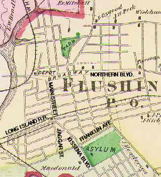
However, through most of its history it wasn’t nealy as long. A look at this Beers Atlas from the late 1800s shows it extending only as far south as today’s Franklin Avenue, and the section below today’s Kissena Boulevard (then called Jamaica Road) was then named Jaggar Street (no relation, we can safely assume, to the Rolling Stones’ head lip-flapper.)
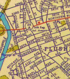
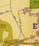
Main Street’s length has gradually lengthened over the years. By the mid-1920s it extended about as far south as Cedar Grove Cemetery. South of that, though, there were several country clubs and golf links that impeded its southern extension.
The above excerpts from a 1940 H.M. Gousha map show that by then, Main Street had attained almost its full length, at least on paper. But prewar Queens was still a vastly different place than it is now, and south of Cedar Grove Cemetery, Main Street stretched through acre after acre of emptiness before reaching its southern limit at the then-new Grand Central Parkway.
Can any Forgotten Fans give me a definite date on when Main Street was cut through to its full length?
If you look at pictures in books of Main Street in Flushing over the years you’ll see that it has undergone more changes than Madonna…from a rural dirt track overhung with spreading trees, to a bustling, small-town main street with mom-and-pop shops and movie theatres, to what it is today…the epicenter of Asian immigrant culture in Queens.
Remember the Main: Main Street in Queens [FNY October 2010]

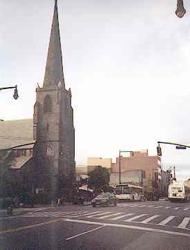
One thing, though, is a constant in all pictures of Main Street in whatever decade you choose to peruse. St. George’s Episcopal Church’s benevolent steeple and churchyard have stood in this spot since 1853.
It’s the third church, actually, to occupy this space, testifying to Flushing’s antiquity. The first church, built in 1746, received a charter from George II. The second church was built in 1821, and this one replaced it 33 years after that, though the second church was used for services until 1930.
Francis Lewis, Declaration signer and namesake of a certain boulevard, served as verstryman in the first church from 1769 to 1790.
St. George’s Church remained the tallest building in Flushing until the late 1980s. Its steeple was blown down by a hurricane in September 2010.
Main Street, and Flushing, begin here. Roads that became Northern Boulevard and Main Street have been here since the mid-1600s…making this corner one of the oldest ones in the United States.
Population growth in Flushing has far outstripped the capacity of Main Street and its radiating streets, and the area is now constantly choked with pedestrian and auto traffic nearly all hours of the day.
A recent Main Street bright spot was the construction of the gleaming new Flushing Library at Main and Kissena Boulevard in 1996-1998.
Fulton Ferry, Brooklyn
Main Street in Brooklyn is a tiny two-block stretch in the shadow of the Manhattan and Brooklyn Bridges between Front and Plymouth Streets. Even at its lengthiest, it was only a four-block street between York Street on the south to John Street on the north. It’s a mystery why it was named Main Street, since it was insignificant even in its salad days.
This 1853 painting, Winter Scene in Brooklyn, by Louisa Ann Coleman, depicts Brooklyn as it was in the mid-1820s.
Front Street, then a fashionable street lined with upper-class residences, is in the foreground. We are looking south with Main Street on the left and Fulton Street on the right. Until the mid-1800s Front Street was indeed the waterfront, before landfill extended Brooklyn into the East River a couple of blocks.
Picture from the Museum of the City of New York.
Now, if we were to be standing in the snow in the scene above, cross Front Street, jump into H.G. Wells’ Time Machine and set the controls about 180 years in the future, this is the Main Street we would see.
The mighty Manhattan Bridge was completed in 1909.
This is the old Sweeney Manufacturing Company Buildingon Water St. and Main Street. Directly across the street is Gold’s Gym.
2002: David Walentas has taken down the ‘Sweeney Mfg. Co” sign, intending to install windows as he converts this building for luxury residential use.
A far cry from the tidy townhouses of the 1820s, Brooklyn between the bridges is now almost totally devoted to industry, although developer David Walentas, who owns One Main Street, is trying to once again bring upscale housing into this area.
Main and Plymouth Streets in 2000 as the bridge was undergoing repairs.
Edgewater Park, Bronx
New York’s obscurest Main Street is located in the private Bronx neighborhood of Edgewater Park, which is wedged north of the Throgs Neck Expressway and south of Eastchester Bay. Edgewater Park is so obscure, in fact, that it wasn’t even represented correctly on maps until the 1980s.
This Hagstrom from the late 1980s is still inaccurate in some ways but it does depict Edgewater Park’s two main streets, Main and Edge.
Edgewater Park has its own rather confusing set of street signage, not the green and white signs seen elsewhere.
One of the Bronx’ few volunteer fire departments stands at the beginning of Main Street, where it meets 5th Avenue (yes, the Bronx has a Fifth Avenue too)
Bucolic Main Street ambles northeast toward Eastchester Bay. Note the absence of sidewalks.
Main Street meets First Avenue at water’s edge. Across the bay is Great Neck, Long Island.
First Avenue winds southeast from Main Street. Houses abut the roadway with no sidewalks. Only a couple of roads connect Edgewater Park to its surrounding Throgs Neck neighborhood; First Avenue continues around and into the Alden Park section of Edgewater.
Roosevelt Island, Manhattan
The newest of New York City’s Main Streets, the Main Street that forms the spine of Roosevelt Island came into being in 1975, when the city-within-a city Roosevelt Island Development was hatched; soon after, dense, rather drab multistory housing was constructed for an initial 5000 families.
Main Street is one of only a couple named streets on Roosevelt Island (River Road along the East River is the other) and its beginning and end is not well-defined. It winds around the now-abandoned Goldwater Memorial Hospital at the south end, then meanders north past the parking lot and then winds around Bird S. Coler Memorial Hospital at the north end.
Nurses quarters of Goldwater Memorial Hospital,constructed in 1939, now stand empty. The abandoned Smallpox Hospital stands south of here.
Since demolished; a condo complex stands in its place.
Main Street begins its northern push.
The 1796 James Blackwell Farmhouse stands near the southern limit of Main Street.
The 1888 Good Shepherd Episcopal Church,now an ecumenical center, is dwarfed by the 1970s apartment buildings constructed around it.
There’s not a lot of green in the downtown section of Roosevelt Island, and even Main Street’s lone park faces the monolithic parking garage.
I believe that part of the reason Main Street looks rather drab is because all storefronts are obscured behind concrete partitions, and the high rise apartments press close to Main Street, permitting little light to shine.
All is not drab on Roosevelt Island, however; its pedestrian and bike trails that surround the island provide plenty of air and sun, and great views, especially on the Manhattan side.
Tottenville, Staten Island
Tottenville is the southern limit of both New York City and New York State. It’s also the southernmost station on the Staten Island Railway, and a ferry (whose slip pilings are still visible) ran from the RR station to Perth Amboy, New Jersey until 1963 (the ferry connecting St. George to Bay Ridge, Brooklyn was similarly discontinued the next year. Till 1964 it was possible to travel from Bay Ridge to Perth Amboy by boat, train and boat! Tottenville is one of many small towns, each still with its own personality and town center, along Staten Island’s south shore, and it still retains its own Main Street–complete with several ancient relics.
ABOVE: looking south; below, looking south. Bank buildings are on both the northwest and southeast corners at Craig Avenue and Main Street.
No movie theatres remain in Tottenville today (residents have to drive to a mall multiplex these days) but the remains of the old Stadium Theater still stand near Amboy Road.
Former Masonic Temple near Amboy Road.
The only pre-war apartment building in Tottenville
Ancient neon sign for Norge appliances just north of Craig Avenue.
Main Street’s southern limit is at Billop Avenue and the undeveloped Conference House Park.
Sources:
AIA Guide to New York City, White & Willensky, 2000 Three Rivers Press
BUY this book at Amazon.COM
New York: A Guide to the Metropolis, Gerard R. Wolfe, 1993 McGraw-Hill
BUY this book at Amazon.COM
12/16/2000, revised 2012

