Your webmaster made fitful forays into extreme southwestern Staten Island (the old town of Westfield) in the 1960s (I seem to remember a bus ride with my parents past endless fields of nothing (likely Arthur Kill Road, which still has a lot of empty stretches) and a two-lane roadway (that was probably Drumgoole Boulevard) and a few years later in the early 1970s, a similar journey, this time alone. I didn’t carry a camera with me everywhere then – I’d like a ride in H.G. Wells’ time machine to correct that error – since much of the southwestern part of the island in no way resembles what it did in the 1960s and 1970s, when the development launched by the completion of the Verrazano-Narrows Bridge in 1964 hadn’t yet spread very far.
Prince’s Bay, Pleasant Plains, Richmond Valley, and Tottenville are small “towns” in all but name, since they were automatically absorbed into NYC in 1898 and their status immediately changed to neighborhoods in a big city. In many ways, they’ve carried on exactly as before. Nassau and Atlantic? For their origin…read on…
Prince’s Bay
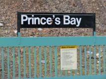
After the Revolutionary War ended, New York City virtually divested itself of royal place names, though Prince Street in Manhattan and Kings Highway in Brooklyn are still there. This small neighborhood in southeastern Staten Island, according to tradition, is so-called because before the War, a British prince, the Duke of Nassau, who later became William III once anchored a vessel in the bay at the foot of today’s Seguine Avenue. The name of the area is properly spelled with an apostrophe, though variants due to mispronunciation like “Princess Bay” have appeared in print, and the local post office styles itself as Princes Bay, without the punctuation. The French Huguenot Seguine family were early settlers in the area: Seguine Avenue, Prince’s Bay’s major north-south thoroughfare, is lined south of Hylan Boulevard with craggy osage orange trees planted by the Seguines at the encouragement of family friend Frederick Law Olmsted, the co-creator of Central and Prospect Parks, who lived nearby in Eltingville. Annadale, as we’ve seen in the previous Stations of the SIRT page, is named for a family member, Anna Seguine.
Prince’s Bay was once a prime area for oyster fishing and harvesting; African-American oyster fishermen founded nearby Sandy Ground in the mid-19th Century. The Samuel Stockton White Dental Manufacturing Company, the largest manufacturer and inventor of dental tools in the world in the 1800s and part of the 1900s, originated in Philadelphia but maintained a huge plant here between 1937 and 1972. Now S.S. White Technologies based in Piscataway, NJ, the company currently produces flexible airshafts for aircraft, and state of the art surgical instruments.
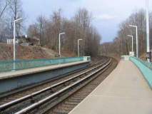
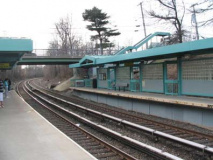
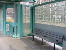
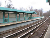
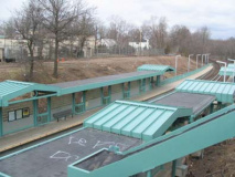
Prince’s Bay SIRT station is located on Seguine Avenue two blocks south of Amboy Road. It probably uses the glass blocks seen elsewhere on SIRT stations to the greatest degree, and its little alcoves and benches in shady areas make it one of the more comfortable places to wait for a train in the system. Prince’s Bay was the last SIRT to feature a platform made of wood planks, which survived till a renovation in the early 1990s. Only the now-closed Dean Street on the BMT Franklin Shuttle lasted longer with wood planks on NYC rail stations.
Vintage Prince’s Bay
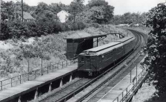
The photos above left show Prince’s Bay in the early 1960s, when standard steel cars worked the SIRT, and the early 1970s, after the standards were phased out and MP50 Long Island Rail Road cars filled in till modified R44 cars, which still run today, were delivered. A steam train approaches the Seguine Avenue crossing around 1910 or 1915.
Note the relatively primitive planks on the platform and goose neck incandescent lights.
Scenes from Seguine
Stepping off the train isn’t initially promising if you’re and architecture buff (though the Joseph Seguine Mansion, 1840, and historic though now-boarded up Manee-Seguine homestead, early 1700s, can be viewed on Seguine Avenue south of Hylan Boulevard).
Prince’s Bay carries on the dancing school tradition your webmaster has noticed at Staten and Long Island train stations. Has Staten Island produced a lot of Broadway dancers or Rockettes? And, street art in this part of town is somewhat tamer than other neighborhoods.
Turn the corner to Florence Place and there’s this symmetrical gem, with twin porches, though I could do without that glazed tile job.
You’ll never be out of shape taking the stairs to this house on Bayview Avenue just south of the railroad.
From Woodvale Avenue. Southwest Staten Island has many small clapboard houses, most of them with front porches. Check the aged conifer at right.
Lemon Creek, the largest of southwest Staten Island’s many creeks and rivulets, crosses Amboy Road under a bridge east of newly-stoplit Maguire Avenue.
Woodvale Avenue follows a twisting route under the railroad, seen south from Amboy Road. Using Lemon Creek as a feeder, the city is constructing a decorative pond.
The Catholic Church of St. Joseph- St. Thomas is flanked by two contrasting styles, both from ca. 1900 — its rectory, above left, and a turreted house with a stick-style porch. Houses from around 1900 have windows sticking out from all angles, making for varying views.
The church has a separate bell tower; we’ll see another later.
ForgottenFan Allie Brim: St. Joseph-St. Thomas (notice no “and” there) has always been one parish. St. Joseph was built over in Rossville in 1848 and still stands today. As the South Shore continued to grow, the parish received permission to build a mission church in Pleasant Plains. Hence, St. Thomas was built in 1939. The building though you have is our second St. Thomas, built in 1995, the first was destroyed by an arson.
St. Mark’s United Methodist Church, nearby on 6144 Amboy Road and Goff Avenue, has been here since about 1875.
Lady of Pleasant Plains
It’s Decoration Day sometime in the late 1930s and crowds are clustering the junction of Amboy and Bloomingdale Roads for a ceremony at the Pleasant Plains World War I monument, dedicated in 1923 and sculpted by Tottenville resident George Thomas Brewster. As we’ll see, however, the statue that stands at the junction today is an exact replica and not the one you see in the picture.
Of interest to your webmaster are the typical Staten Island street signs of the era, colored yellow and black, many of which survived till the mid-1960s, and the “gumball” luminaire and globe fire alarm light mounted on the telephone pole mast. Gumballs were newly in vogue and were replacing the older “acorn” pendants you see mounted on poles in the rear. Also, note that when a fire alarm indicator was mandated, the mast was simply flipped over so the metal scrollwork was at the top of the mast instead of the bottom, as usual.
Pleasant Plains Avenue is a relatively wide boulevard extending from Amboy Road only as far west at the south service road (Drumgoole Road South) of the Korean War Veterans Parkway. Until the parkway was built in 1972, however, it was much more important, since before that it was the road to the Outerbridge Crossing (1928) and thus a direct link to New Jersey from the island.
I’m sure she doesn’t mind my shooting a picture from the rear; J-Lo has nothing to worry about; and unless you’re here in the morning, the sun is right in your face in front. This is actually a replica of the original, since after 1970, after one car crash too many, she was removed to storage and was hidden too well, since no one knows what happened to it. Working from photographs, sculptor Glenn Hines, working with the fabricated by Modern Art Foundry of Queens, recreated it in 1996 and it was dedicated the following year, this time in a more substantial raised traffic island. So far, so good.
All 493 combatants from Staten Island’s former 5th Ward (including Pleasant Plains) names are inscribed on three tablets at the statue’s base. The 4th lists the 13 who lost their lives.
This building on Amboy Road was built before the war or the memorial to the war; in recent years it has hosted a succession of pizzerias and ristorantes.
A cluster of stores and buinesses, including the obligatory dance school, cluster around the next Staten Island Railway stop…
Pleasant Plains
Pleasant Plains, the neighborhood, grew up along Amboy Road after the railroad arrived, not before. It was apparently given its name by officials of the Staten Island Railroad Corporation, the original owners of what is now known as the Staten Island Railway. When the railroad line was extended to Tottenville in 1860, a station crossing Amboy Road approximately two miles north of Tottenville was named Pleasant Plains (this is one of three points at which the railroad crosses this same street; the other crossing points are just south of the Bay Terrace and Huguenot stations). Eventually, the name “Pleasant Plains” was applied to the community which soon sprung up around the station. wikipedia
There’s a short walk between Amboy Road and the platform, which is set forward a little from the street. There’s just a bit of the usual SIRT shelter and glass block treatment here, and the station railings are the only ones on the SIRT that match, for some reason, typical Long Island Rail Road station railings. West of here, a spur led to the Mount Loretto orphanage until 1950, with tracks crossing Amboy Road remaining visible until 1980 or so. Pilings that carried the tracks are still there.
Down to the Valley
West of Pleasant Plains, toward Richmond Valley, Amboy Road runs along the northern edge of the Cemetery of the Resurrection and the Mission of the Immaculate Virgin, a.k.a. Mount Loretto, established in 1882 by the Roman Catholic Church with the assistance of Father John C. Drumgoole. Labor and antiwar activist Dorothy Day (1897-1980), a Staten Island resident, is buried in the cemetery.
After curving past Bedell Street, guarded by a rare double-flashing amber light, Amboy Road enters astretch punctuated by a cluster of very old, picturesque homes…
Gorgeous 6475 dates to the early 1820s.
I like 6498, even though it’s awash in mustard. Developers must be salivating over all that land.
Stick-style arts and crafts at 6505.
Roadside Staten Island
Hollywood Garage was closed the Saturday I was by but their collection of bugs made out of household objects was in view. Apparently they do custom auto body work. The watchdog hasn’t been around since 1938.
A bit further west, Mill Creek is another of Staten Island’s protected open spaces. The creek is protected rather obviously though, with chicken wire holding back silt.
Is it a pond or just a big puddle? The decorative element in front seems to be the tipoff.
At 6713 Amboy, you have to love the detail work at the roof peak, and your webmaster is an aficionado of the colored glass panels surrounding the windows. As Kitty Kallen has reminded us, little things mean a lot.
Scaran Oil, 6767 Amboy, which owns a fleet of trucks in the same sea green color as the sign, began in 1930 as an ice and coal distributor, and has had to adjust.
A fork in the road formed by Amboy and Richmond Valley Roads marks our official entry into the neighborhood, one of Staten Island’s remoter outposts. Not much has happened in Richmond Valley, to be frank, except the 1993 opening of the massive interdenominational Gateway Cathedral on Boscombe Avenue.
The sign is interesting, since Richmond Valley had always been considered a part of Tottenville until it gained its own RR station in the 1860s. Anyone know where the 1828 date comes from?
The bridge carrying Richmond Valley Road over the railroad is notable since it still has a pair of 1950 octagonal shaft poles, that originally carried Westinghouse “cuplights.” How do I know they’re originals? Elementary…it’s the shaft apex ornament, which forms a neat line with the pole. Later ornaments, from about 1960 on, jut out a little. This bridge replaced a grade crossing in 1940.
Richmond Valley, as we’ll see, is the last of the SIRT stations that received a refurbishment in the 1980s-1990s; the new station was completed in 2000. Here the station railings revert to the style typically seen on other platforms. Northbound (St. George) trains are accessed from Amboy Road, while southbound (Tottenville) trains have agress and entrance from an odd spur of Richmond Valley Road that trails from the main road, which bridges over the tracks.
While riding south, if you are sitting on the right side, notice a spur track: the Tottenville-bound track has a non-electrified spur that once ran all the way to the Arthur Kill. The spur was built in the mid 1920s and dubbed by the [Baltimore and Ohio, which ran the SIRT until 1971] as the West Shore Line. The B&O delivered building materials to the Outerbridge Crossing construction site near the Kill. There was also a small industry on the spur known as Roselli Bros. The track remains intact today all the way to Page Ave. The switch at the spur is well kept and working. nyscubway.org
NYCSubway views of the Richmond Valley spur
The Richmond Valley Road spur (likely a part of the original road before the grade cross was eliminated) faces a goose pond. And do these guys honk.
Miles from nowhere. Views of Richmond Valley Road between Amboy and Arthur Kill Roads, one of Staten Island’s more isolated stretches. Actually a driveway to the Gateway Cathedral is being constructed here, and i wouldn’t bet on this stretch remaining as is in 5-10 years.
Paging William Page
Page Avenue and Amboy Road, 2007; same scene, about 1945. There’s not much to see on Page Avenue, unless you’re in the mood for gigantic malls and auto body shops, but note that in the photos above, you can see the same two buildings. Page Avenue is a main conduit from the Outerbridge crossing approaches to Hylan Boulevard; at one time, it was supposed to funnel traffic onto an expressway that was to run along Staten Island’s south shore, but that Mosesian project was scrapped in the 1970s.
In the 1940s, Page Avenue had some rare standalone lampposts (Type G’s to be exact). In this part of town most lamps were mounted on telephone poles, and today most still are. Page Avenue was very quiet back then. Orchard Inn Reunion
A pair of old-school traffic signs on the SE corner of Page and Amboy. These beige and black signs were phased out in favor of green a couple of decades ago. LEFT, Adelphi Avenue trails off to a dead end. If you squint you can see a ruined shack off to the right.
Page Avenue is named for William Page (1811-1885), the best known portrait painter of his era. His subjects included John Quincy Adams, James Russell Lowell, Charles Sumner and fellow Islander Colonel Robert Gould Shaw. His paintings are in the collections of the Metropolitan Museum, New York City Hall, Boston Art Museum and Harvard University. He first moved to Staten Island in the 1840s and then in the 1870s he returned to his “Octagon House” on Page Avenue in Tottenville after an eleven year stay in Italy.
His home was in a spot noted for its extreme beauty, as it overlooked the Staten Island Sound [sic.] The house was octagon-shaped, and was built, according to report, to enable the noted artist to better carry on his work, secure the best lighting, etc. A studio formed an important feature of the residence. For many years Page lived there, on Beach Street, as it was then called, although it has now been named in his honor, Page Avenue. The estate bore the peculiar title of “Folly Farm,” a name which it still holds, although the house burned down some 15 or 20 years ago, a grove of trees marking the site once graced by the residence of one of Americas’ greatest painters. The foundation stones of the house are still visible. Staten Island’s Claim to Fame, Vernon Hampton, Richmond Borough Publishing, 1925
Hm, I wonder if that foundation is still there…where to look?
If you want to join a fraternal organization, you’re covered in Tottenville….where we will visit in the next section.

