BY SERGEY KADINSKY
With the exception of Forest Hills Gardens, the Rego Park Crescents, and Corona Park, most of ?Rego Park, Forest Hills, and ?Corona are divided into a rectangular street grid, imposed in the 1920s. Prior to the grid, the future Rego Park and Forest Hills were separated from Elmhurst and Corona by Horse Brook, a stream originating near Codwise Place and Grand Avenue in Elmhurst, running towards Justice Avenue and Broadway. From there, it followed Justice Avenue and the future Long Island Expressway towards Flushing Meadows, where the stream joined the Flushing River. Today, large superblocks, street triangles, and a few alleys stand as reminders of this long-gone stream.
In the Beginning

HORSE BROOK ISLAND
Justice and 56th Avenues
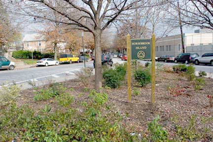
Under Parks Commissioner Henry J. Stern, two Greenstreets triangles in ?Elmhurst were dubbed ?Horse Brook Island, to keep the memory of the stream alive. The stream was used by the townsfolk to water their horses, hence the name. Justice Avenue is named for the Newtown Town Hall, which stood on the corner of Broadway and Justice Avenue until 1966. This street runs along the path of an ancient railway, the White Line, which diverged from the Flushing and North Shore Railroad at Winfield and reconnected to it in Flushing, passing through Newtown and Corona Park. It was a short run, for the White Line opened in 1873 and went extinct in 1876. In 1897, Newtown was renamed Elmhurst to disassociate it from the foul-smelling Newtown Creek.

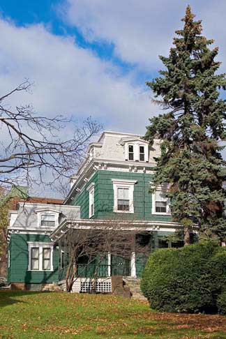
A lone Victorian-era home stands nearby that must have been here when horses watered in the brook, and trains rattled on long-vanished tracks. A block away, the massive Queens Center Mall provides a much different view. The expansion of the mall is atop a parking field built on the Horse Brook streambed.
According to area historian Mike Pearlman, this house dates back to the mid-1860s and is the Colonel Bernardus Bloom farmhouse. Parts of the house may be even older, since the land on which the house stands was purchased by the Bloom family in the 1740s in Newtown.
Tragically, the house was damaged by a fire in September 2015 — after being put up for sale. It has never been landmarked.
1923 photo of the house from the NY Public Library digital archive.
1873 Beers map of Newtown featuring the LIRR White Line (Newtown and Flushing RR), Horse Brook (center), and the North Hempstead Plank Road (the jagged road below the brook), north to south. At the time, the Flushing River could be crossed at only two places, Northern Boulevard and Strong’s Causeway (the line just south of the word “Creek” at right.
For the entire 1873 map of Newtown, see Brooklyn Genealogy.
Strong’s Causeway in the early 20th Century. It was replaced by Nassau Boulevard and later, the Horace Harding (Long Island) Expressway in the 1950s.
Tributaries: this 1898 topographical map shows a tributary stream to the south of Horse Brook. Emerging from a steep and narrow valley, it was known as Whitepot, and eventually became Yellowstone Boulevard, which curves to follow the path of the tributary. The stream to the north of Horse Brook between Newtown and Corona later became the site of Lefrak City.
The curvy road on the map’s extreme left is Broadway, with Queens Boulevard and Justice Avenue hugging both sides of the stream. This is the heart of historic Newtown.
The road that parallels the stream to the south is the North Hempstead Plank Road.
The “electric railroad” crossing Flushing Meadows is Strong’s Causeway. Eventually, this streetcar line became the route of the Q58 bus, which connects Ridgewood to Flushing. Strong’s Causeway was replaced with Nassau Blvd. in 1939, and later the Long Island Expressway.
Two decades later, Forest Hills, shown on the bottom of the map, was laid out by ?Cord Meyer. The sizable empty areas along Horse Brook were wetlands, and as a result, they defied the grid for a few years longer. Eventually, the superblocks making up Lefrak City, Rego Park Estates, and the Queens Center Mall would be built atop the stream bed.
Along the south bank of Horse Brook was North Hempstead Plank Road, later incorporated into today’s 63rd Road, and the other green-colored names on the map. The road began in Maspeth as 57th Avenue, running towards Queens Boulevard. It shares paths with the boulevard until 63rd Road, where it continued its run eastward.
The yellow paths are today’s major roads, including Queens Boulevard, Corona Avenue, and 108th Street. The village grid of Corona Park is diagonal to the grids north and south of it.
Two street grids collide at Junction Boulevard and 62 Drive, creating potential for a Greenstreets park. The fortified brown structure belongs to AT&T and is mentioned in the AIA Guide to New York City. The city approved the telephone exchange in 1976, with the requirement that AT&T build a playground and maintain it for 10 years. Behind it is the Lost Batallion Playground, named after a group of WWI heroes. In the background is the main Lefrak City office building, which has DEP and IRS offices inside.
The Rego Park Mall expansion will include a Century 21, a Home Depot, and other well-known retailers. The project costs approximately $550 million. Because it is being built on the site of Horse Brook, the construction pit is inside a bathtub, similar to the World Trade Center.
Apex Place
Apex Place is a short lane in Forest Hills, just south of the LIE, connecting Yellowstone Boulevard with 62nd Drive near 108th Street.
It is a remnant of the ancient North Hempstead Plank Road. The 1853 map to the left shows Apex Place. At the time, only three families appear on the map, the Lott, Jarvis, and Rapelye families. The Rapelye name appears on Queens maps from the Dutch days to the early 20th century. Today, no Rapelyes are listed in the Queens phone book. They all moved on.
(Real estate developers probably renamed the cut-off portion Apex Place, in the word’s sense as the topmost point or best place.)
62nd Drive continues North Hempstead Turnpike’s old course between Apex Place and Colonial Avenue. Alex Braginsky, an immigrant from Odessa, Russia, was a Foreign Exchange Products Manager at Reuters and was at Windows on the World at the WTC on 9/11/01.
Colonial Avenue
On the map above (see Apex Place entry), Horse Brook is crossed by the future Colonial Avenue at Coe’s Mill. The first European development on Horse Brook began in 1652, when Captain John Coe built a mill on Horse Brook roughly where Colonial Avenue hits the Long Island Expressway. The mill was built on a small island in the stream. His father Robert was a founder of Hempstead and also bought Jamaica from the Jameco Indians. In 1655, the residents of Maspeth and Newtown (later renamed Elmhurst) paid for a road to the mill, which supplied their villages with grain and corn. Nine years later, the Dutch-controlled territory passed into English hands. The location of the mill is near at the junction of Corona Avenue and North Hempstead Plank Road. These two roads united on their way east into Strong’s Causeway, crossing Flushing Meadows. To the west, Corona Avenue went towards Newtown (the future Elmhurst); and North Hempstead Plank Road went towards the future Middle Village and Brooklyn. It was later renamed Colonial Avenue.
Coe’s Mill appears on the left, and the Coe’s Mill (William Geyer) Hotel appears on the right in this early 20th century view. The streambed is now covered by the Long Island Expressway. This photo is from “Story of Corona” by Vincent Seyfried
The same location is totally unrecognizable today. In 1930, Coe’s farmhouse and hotel were unceremoniously demolished and by the end of the decade, the future Long Island Expressway was rammed through the site. Fill for the streambed was brought in from the nearby Queens Boulevard subway excavation.
Corona Park
Coe’s Mill stands where North Hempstead Plank Road crosses Horse Brook. At the crossing is a small isle. This map was designed at the end of the 19th century. By then, the White Line right-of-way was being gradually gobbled up by developers. The village’s main street, Broad Street kept its extra width and later renamed Saultell. On the left, an alley named Westside Avenue delineates the village’s original western border. The one-lane alley still exists today. As for the isle, it’s as wide as the highway that was built on top of it.
From top to bottom we see Corona Avenue, Highland Avenue (now Van Cleef Street), Hillside Avenue (now Van Doren St.), Lawn Avenue (now Waldron Street). The old White Line ROW appears as the white stripe in the center.
Alphabet Soup
In 1898, Queens joined New York City, and planners had grand ambitions for the entire borough, blanketing the largely empty map into a uniform rectangular grid. This map ignores the presence of Horse Brook and dares to extend urbanization into Flushing Meadows. At the same time, while most colonial-period farm lanes were eliminated, there were two exceptions: Apex Place and Colonial Avenue, which were allowed to remain as remnants of the North Hempstead Plank Road, slight skewing off the grid.
108th Street was proposed by the city’s Board of Estimate in 1916 as a route for a trunk sewer line. It would run as a straight line from the Corona to Forest Hills, cutting through some of the old Corona Park blocks. Residents were compensated and construction began in 1918. Initially dubbed Central Avenue, it crossed Horse Brook atop of 15 feet of landfill.
From 75th Avenue to 63rd Drive, Cord Meyer gave northern Forest Hills an alphabetical street grid ranging from Atom to Zuni. Unlike southern Forest Hills, which had purely British names such as Austin, Burns, Clyde, and Dartmouth, northern Forest Hills had diverse names such as Euclid, Meteor, Nome, and Pilgrim. The five blocks between Zuni and the future Long Island Expressway were also given names. The street following Zuni was named Omega, after the last Greek letter, signifying the edge of the neighborhood. The old North Hempstead Plank Road between Apex Place and Colonial Avenue was straightened and renamed. Some early maps call it Urania, while others say Urquhart. The latter is a Scottish last name and its namesake may be the map’s surveyor or someone connected to the developer of the neighborhood. By the late 1920s, the city decided to assign numbers to the street grid, and Urquhart became 62 Drive. Only Jewel Avenue remains from this whimsical naming sequence.
While mapmakers were busy, the area along Colonial Avenue remained undeveloped due to the presence of the wetlands. At the time, Coe’s Mill served as a hotel, and it received mention in the 1906 Historical Guide to the City of New York. For the next thirty years, the stream gradually dried up as its source neighborhood, Elmhurst, expanded over the stream bed.
A sitting duck: The Coe House appears to be on the median of the future ?Long Island Expressway, at the time dubbed Nassau Boulevard. The streambed occupies a super-block where the Forest Hills Co-op Houses will stand.
Change arrived in 1929, when the Board of Estimate proposed a Flushing River Park for Flushing Meadows. In 1934, master builder Robert Moses decided to use the park as the site of the ?1939-1940 World’s Fair. Previously used as a landfill, the area would be transformed into the largest park in Queens. To improve transportation to the site, Strong’s Causeway would be replaced with Nassau Boulevard, as the future Long Island Expressway was initially named. To build the highway over the Horse Brook wetlands, fill was brought in from the nearby Queens Boulevard subway excavations.
To build the highway, Coe’s Mill and the William Geyer (Coe’s Mill) Hotel were unceremoniously demolished. Colonial Avenue was severed into two and eventually its northern half was absorbed into the service road, named after highway promoter Horace Harding.
Draining Horse Brook
RIGHT: Part of the plans for the World’s Fair (1939-1940) included the damming of Flushing River into two lakes. In this photo, Horse Brook drains into the 84-acre Meadow Lake. For the Fair, the lake was temporarily known as Liberty Lake and Fountain Lake. Within a decade, even this trace of the stream would disappear.
LEFT: The brook is drained as the cloverleaf interchange between the Grand Central Parkway and the Long Island Expressway approaches completion. For another decade, the last two blocks along the streambed remained undeveloped. [queenspix]
Forest Gardens
With the construction of the Queens Boulevard subway, the Forest Hills neighborhood gradually crept northwards towards Horse Brook. Nevertheless, the streambed remained undeveloped. It was not until 1950, when the postwar demand for housing led to the construction of the remaining blocks on the site of the Horse Brook wetlands. Similar in style to the attached houses of Kew Garden Hills, Glen Oaks, and Oakland Gardens, the Forest Garden Apartments featured large lawns, parking garages behind the homes, and strict architectural conformity.
On the left, the Forest Gardens homes. On the right is an aerial view of Georgetown Mews in Kew Garden Hills. Within a decade, the developers of the Fairview Apartments came knocking and most of the homes on the block were sold. New technology enabled builders to drain more water, dig deeper, and build higher. In 1965, the Fairview Apartments opened and were named for the 1964-65 World’s Fair that was taking place across the Grand Central Parkway. A luxury development, the apartments have a swimming pool, garage, laundry room, and voting booths.
The large front lawn shared by the residents was replaced with a paved cul-de-sac in order to compensate for the backyard parking spaces lost to Fairview. In addition, the apartments were turned into private homes and over the decades its owners altered the homes to their personal tastes. Today, some of these homes are painted beige, some white, and one pink.
By 1960, Lefrak City (background) was built on the largest of the Horse Brook parcels. Across the highway, the Vornado Corporation began the expansion of the Rego Park Mall in 2006 on the long-vacant Alexander’s parking lot.
The most controversial of the three sites was the Forest Hills Co-op Houses. In the post-war years, the 8.5 acre block served as a golf driving range, while development plans failed to get off the ground. Initially planned in 1966 as a public housing site, it was unpopular among local residents due to its scale and the negative image of public housing. Under attorney and future governor Mario Cuomo, a compromise was reached. When construction began, some 300 local residents held a torchlight protest against the building, where construction trailers were damaged, and traffic on the Long Island Expressway was blocked. The protest was led by Jerry Birbach of the Forest Hills Residents Association.
Fear In Forest Hills [Time, Nov. 29, 1971]
This view looks upstream. On the left are the Forest Hills Co-op Houses. On the right is Corona. The tallest structure on the right is the Lefrak City office building. There are two gas stations facing each other across the highway. Before 1939, Colonial Avenue used to connect them, and Coe’s Mill stood between them. The stream and its isle are completely buried by the expressway.
The public houses would be co-operatively owned with a sizable percentage reserved for the elderly. There would be only three 12-story towers. In 1975, the towers opened to residents and the former site of the reservoir created by Coeís Mill was forever erased. At the same time, the large size of the blocks on which Fairview and the Co-ops stand testify to the presence of the stream that challenged the early grid surveyors.
One of the legislators in the area involved with the compromise that enabled the construction to take place was Assemblyman Ralph Goldstein, who served between 1976 and 1986. Among the bills that he sponsored was the 1984 “Lemon Law,” protecting the rights of used car buyers. As an honor, street signs on Colonial Avenue feature his name. Another honorific is Alex Braginsky (see above) a Russian Jewish immigrant whose parents lived in the Forest Hills Houses. Known for his generosity, he worked in the World Trade Center and was killed in the September 11th attacks. In 2004, the City Council voted to install honorific street signs on the block where he lived.
That’s a mouthful: Colonial Avenue/Assemblyman Ralph Goldstein sign at 62nd Drive; the traingle at 62nd Drive and Colonial Avenue follows a bend in the old N. Hempstead Plank Road a block away from the site of Coe’s Mill and Horse Brook.
In recent years, the architectural uniformity of the surrounding neighborhood has been broken up by homeowners desiring to cash in by expanding and renovating their homes. Lawns have been paved to maximize parking spaces, bay windows pop out of the walls, and extra floors stick above the rooftops.
Colonial Avenue, seen from the air
Above is an aerial view of Horse Brook’s approximate path (blue), and the North Hempstead Plank Road (green).
SOURCES:
Historical Guide to the City of New York Edited by Reginald Pelham Bolton & Edward Hagaman Hall. Publisher: City History Club of New York 1906
Corona: From Farmland to City Suburb (1650-1935) aka The Story of Corona (Queens Community Series), Vincent Seyfried, Edgian Press, Inc. 1986
Elmhurst: From Town Seat to Mega-Suburb (Queens Community Series), Vincent Seyfried 1995
“Metro Matters; Forest Hills ’72: Some Parallels To Queens Arson” Sam Roberts. New York Times 4/27/1987
Sergey Kadinsky
Sergey Kadinsky has been living in Queens since age eight. His interest in journalism can be traced back to childhood, when he made a hobby out of writing letters to the editors of local newspapers. He is a writer who aspires to a career in journalism and politics. At times, he has been spotted giving tourist-friendly monologues atop Gray Line buses. He also paints murals that contain maze puzzles. His website is mazeartist.
