Coffey Street in Red Hook and your webmaster have never been close associates, but have been, shall we say, acquaintances over the years. I first laid eyes on it sometime in the Super 70s, in high school, when the van transporting us kids made a pit stop there to pick up a classmate, Ed Burkard. Remember the name Burkard … we’ll revisit it. All I remember of the visit is that the street was way out of our way.
I didn’t see it again until my sporadic bicycle scouting missions into Red Hook in the late 1980s and early 1990s, when I still lived in Bay Ridge. In those days, much of Red Hook was junkyard dog territory, if not dead dog territory. Coffey Street, in fact, remained one of the only habitable streets in the area, to my lights at least. When I began shooting Forgotten things in 1998, my eye was drawn to a sign at Coffey and Conover. More later.
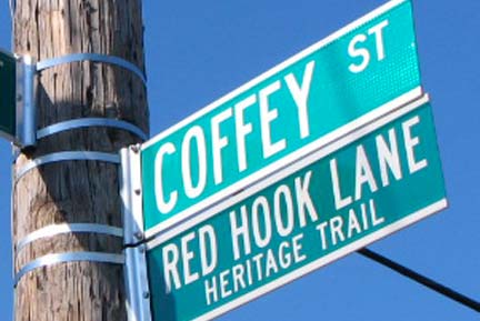
A block of Coffey Street between Ferris and Conover has been subnamed the Red Hook Heritage Trail, largely through the efforts of Coffey Street historian John Burkard (father of Ed). Red Hook Lane was formerly a colonial route that led from Red Hook to what was then the King’s Highway but is now Fulton Street.
According to Burkard’s research, the lane was a conduit for British troops during the Revolutionary War…
In his book Town Of Brooklyn, [Gabriel Furman] spoke of the Battle of Brooklyn, and of a lane that wound its way down into Red Hook. He wrote of American snipers hiding in trees along this trail and firing upon the British troops who were pursuing them hoping to cut off their escape during the famous withdrawal General George Washington ordered the night of August 29, 1776. This withdrawal was credited with saving the Continental Army from certain defeat. Mr. Furman went on to write of one sniper who though fully aware he would be discovered, continued to fire at the British allowing his comrades to escape. When he was eventually exposed, he was shot and killed, and his body lay where it fell for a number of days. This was the British way of setting example for the Colonists, to let the American dead remain and rot and have their flesh eaten by the vultures.
Eventually he was interred by friendly locals, in a hollow tree trunk that had been struck by lightning during a storm, this became his final resting place. However he had slain two British soldiers, a Major Grant and an aide during this heroic action. They are also said to be buried at this site along the lane. It is unfortunate, we do not have the name of the heroic American soldier. But it just so happens, the gravesite I mentioned, is only one half block from where this Lane ran on its way to Fort Defiance located at the lanes end and terminating in Red Hook.
In April 2008 John Burkard (who once identified a cannonball in a neighbor’s back yard as dating back to the Revolutionary War) realized a longtime dream when a number of streets zigzagging through Red Hook were designated the Red Hook Lane Heritage Trail by the NY City Council. The old lane followed a straighter path, presumably, but since it was long ago paved over and built on except for a very short section downtown, the zigzag will suffice.
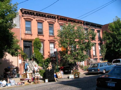
Attached brownstone-esque buildings on Coffey between Ferris and Conover along the Red Hook Heritage Trail.
Coffey is, like the rest of Red Hook of which it is a microcosm, in a transition between viable, lived-in decades-old buildings interspersed with ruins and new construction — we’ll see that just below this.
Who’s the actress (Lillian Russell perhaps?), who’s the artist?
Coffey, and its exposed Belgian block roadbed with a ’67 Ford Fairlane, looking SE past Conover.
One of my first Forgotten forays was into Red Hook in June 1998 with NYC’s former King of Lampposts, Jeff Saltzman (he abdicated the title, since claimed by Bob Mulero, when he and family moved to North Carolina). Jeff you see had a zoom lens, which, amazingly I did not acquire till 2001 or so. A telephoto was called for to get a good picture of Coffey Street’s old name, Partition Street. (You often find Partition Streets on old city gazetteers — lower Manhattan used to have one — but I don’t know what was being partitioned.). In the early days of the 20th Century the name was changed to commemorate a 12th Ward (Red Hook) district leader, Michael Joseph Coffey, who rose to state senator.
1968 Ford tough on Conover.
I was surprised to see that the parachute maker who had renovated the corner building had moved next door and a new bistro, Botanica, had assumed the space. Red Hooker Amy Langfield says you can get a $35 beer in there, but I’ll settle for Killian’s Red. Is that place still there in 2011?
The winds of change have begun to rattle on Coffey. This is a cut above the usual Fedders, but it’s all so orderly. Compare the houses with the bad siding. Just more authenticity.
127 Coffey, built in 1931, was in tough shape until just recently — it has a new lease on life.
Next door, 125 Coffey is now completely different from when it was built…
… but 89, across Van Brunt, has been left alone for quite awhile.
In 2005, the New York Observer’s Matthew Grace had some pithy comments about 73 Coffey Street between Van Brunt and Richards…
Before the Nazis co-opted it, the swastika was merely a sign indicating the hope for peace, luck, prosperity, that kind of thing. Swastikas can be found all over town in pre-1930s buildings. They can even be found in the subway system.
Then there’s this building of indeterminate age, on the SE corner of Coffey and Richards. It seems the street artist who calls him (her?)self Elbowtoe has had a go at it.
The building certainly has a saucerful of secrets. The ground floor was a restaurant long ago; you can see an aged Singer and some lanterns behind the gate.
As decrepit as the ground floor is, the top floor is apparently occupied.
The house (199 Richards) has been through several stages of renovation; the fake brick siding is peeling off, revealing the wood construction underneath.
Red Hook has a number of spooky joints like this; even on Van Brunt, the nominal main drag with the restaurants and bars, you still stumble on storefronts with dusty objects that have not been touched since LBJ was in the White House, if not JFK, DDE, HST, FDR, HCH…
The place has a back yard … maybe the ghosts sit out there. The fence has an ANcient EXchange name: CLoverdale 6-5024.
Finally, at 53 Coffey… I haven’t seen him, have you?
The sign went down after May 2, 2011, when bin Laden was shot dead by the US Navy Seals.
Photographed September 21, 2008; page completed October 8.


