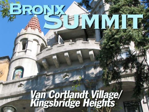
I became so enamoured of the Van Cortlandt Village/Kingsbridge Heights area while doing ForgottenTour 37 around the (temporarily dry) Jerome Park Reservoir that I resolved to return and explore these two obscure Bronx enclaves a little more in-depth, and that’s exactly what I did on September 20, 2009. There’s no clear boundary between the two neighborhoods, so I’ll just say that you can find each of them east of Broadway, south of Van Cortlandt Park, west of Mosholu Parkway and the reservoir, and north of Kingsbridge Road. Unlike most of NYC, streets lazily wind up and down hills and the pace is rather languid. It’s the Bronx, though — stay on your toes.
WAYFARING: VAN CORTLANDT VILLAGE/KINGSBRIDGE HEIGHTS
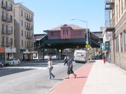
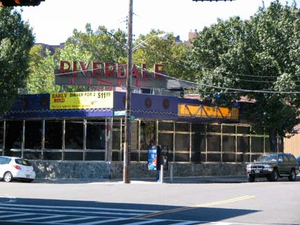
I began the tour after alighting from the 238th Street station on the Broadway IRT el. Across Broadway was the tempting Riverdale Diner, constructed by the Kullman diner company in 1961. Believe it or not I have yet to sample the Riverdale (but I have eaten at the Tibbett, about a mile south on Tibbett Avenue, that is presently rebuilding after a fire). RIGHT: all stations on the IRT el above Dyckman Street north to the terminal at 242nd Street have these chalet-style station buildings. The #1 line ultimately serves Broadway and 7th Avenue further south; a new southern terminal at South Ferry opened in 2009.
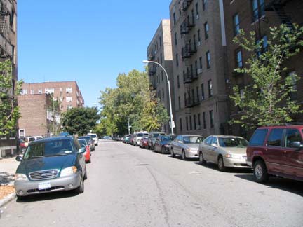
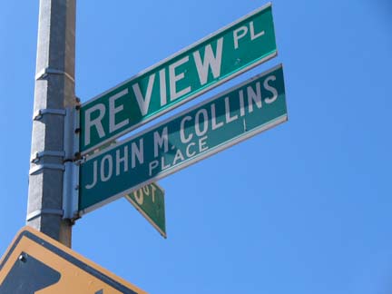
Review Place runs for 2 blocks between West 238th and Van Cortlandt Park South. Turning to my dogeared John McNamara History in Asphalt, I discovered that Review Place likely commemorates a time when military parades were held in Van Cortlandt Park (which I hope you’ll forgive me if I refer to it as VCP for the rest of the page). Military parades and drills were also held in Washington Square Park in its early days, as well as Brooklyn’s Parade Grounds. (There are two streets called Review in NYC: this one and Review Avenue in Blissville, Queens. Marching bands and processions heading to Calvary Cemetery used the road, hence the name, says Mitch of the Newtown Pentacle.) John M. Collins was a firefighter who perished on 9/11/01; the City subtitled Review Place for him in December 2004. As a rule, firefighters are usually identified as such on these signs, but not not in this case.
Crossing Bailey Avenue and ignoring it for now (it will turn up later) we see West 238th Street having to twist up a substantial hill. Kingsbridge Heights as well as other neighborhoods in western Bronx such as High Bridge, Morris Heights, University Heights, Spuyten Duyvil and Riverdale all are very hilly and in some spots you can have some spectacular views, especially in the areas that are close to the Hudson River. These hills were left by the passage of a glacier tens of thousands of years ago.
It is amusing, especially for me, at least, to see the very same streets that are an outgrowth of the severe grid of the 1811 Commissioner’s Plan for Manhattan have to make these severe twists and turns to ascend the hills as easily as possible. Numbered streets further west in Riverdale are more or less bucolic in appearance — a far cry from the concrete canyons of Manhattan. Manhattan and the Bronx are brother boroughs and were joined like Siamese Twins Chang and Eng until 1914, when they became separate counties. Thus, they share the same street numbering and house numbering. By the way, Chang and Eng and the Commissioner’s Plan both first appeared in 1811!
As we ascend on West 238th, glance at the magnificent yellow-brick apartment building (the bedrock is quite deep in this part of the Bronx, making some very tall apartment buildings possible). Of course I liked the pair of ornate lamp stanchions guarding the entrance. But why are the globes colored green?
After passing the apartment building West 238th cleaves into Orloff Avenue, which turns north, and Fort Independence Street, which heads south. West 238th ascends the steep hill as a step street.
Curving Cannon Place intersects equally twisty Orloff Avenue twice. As you can see from a 1923 atlas, Cannon Place “secretes” a small shoot to deliver traffic to Orloff.
A street sign post at Orloff and Cannon Place has been completely taken over by ivy. When I first began inspecting Bronx maps as a kid in the 1970s, I held Orloff Avenue in a vaguely sinister light, because it sounds like “Karloff.” Actually, Orloff is named for the first Van Cortlandt to arrive in North America, Oloff Stevense Van Cortlandt. Two area streets are named for him and both are misspelled, Orloff Avenue and Stevenson Place (see below). You can’t toss a dead cat in this part of the Bronx without hitting a street named either Van Cortlandt or Kingsbridge.
Speaking of Boris Karloff, he spends the full hour of this episode of The Girl from UNCLE in drag. Me, I was viewing Stephanie Powers, who was much more pleasant to look at.
Continuing on Orloff, there’s a nice mix of pleasant houses, some Tudors and some high rises that are esthetically not too bad. The guy on the right put a rather bizarre enclosed porch on the front; he should have matched the original brick color. There’s another step street leading down to Bailey Avenue as Orloff Avenue crests the hill.
The walkway is lit by these standard issue high intensity lamps. But take a look at the top of the telephone pole facing the step street.
This type of stanchion is usually employed to hold the familiar orange fire alarm indicators and are used on telephone poles. However, long ago, I saw them occasionally used to hang
this design of lamps used to illuminate basketball and handball courts, and they may have lit the stairs. That light would have been very feeble, though.
Cannon Place intersects Orloff Avenue once again. Though a modern day monstrosity is being built on the corner, a casement windowed Tudor beauty is right next to it.
Truly the Bronx is the Borough of Apartment Buildings. This one may be boxy and no frills, but it gets the job done at Orloff and Van Cortlandt Avenue West.
There are a number of streets named for the Van Cortlandt family in the Bronx, as well as its biggest park. There’s Van Cortlandt Avenues West and East, VCP South (told you I’d do that), VCP East in Woodlawn, and there’s Courtlandt Avenue in Morrisania.
The city doesn’t always make it easy for you to tell what Van Cortlandt you’re on. Take this sign on the corner of Orloff and Van Cortlandt Avenue west, for instance. What happened is the Department of Transportation mistakenly labeled it Van Cortlandt Park West. No such street exists (if it did exist it would take Broadway’s place) so the DOT hastily covered over “Park.” Making the situation even more confused.
Van Cortlandt Avenues West and East never meet — they are separated by several avenues and Jerome Park Reservoir. Because Jerome Avenue separates East streets from West streets, West’s numbers go up as you go west, while East’s do the opposite. Van Cortlandt Avenue East was once a part of the old Boston Post Road.
Van Cortlandt Gardens. The old Dutch family would be proud to see their name used so frequently in these parts. The apartments line Gouverneur Avenue between Sedgwick Avenue and VCP South. The apartments maintain that unusual borough-wide practice of curving around corners — apartment houses in Brooklyn and Queens don’t do this, and in Manhattan there are few curved streets.
The land between Jerome Park Reservoir and VCP was once part of a vast estate owned by John Dickinson, who apparently was a history buff, especially medieval history. Three one-block avenues in the area honored particulars in the Battle of Hastings: the Normans, the Saxons and Harold, the Saxon king who was defeated and killed in the battle on October 14, 1066. (The winning monarch, William the Conqueror, was not so honored here, but the lengthy Williamsbridge Road could be said to stand in for him.) Only Saxon Avenue still has its old name: Norman Avenue became Hillman Avenue (see below) while Harold Avenue became Dickinson Place.
VCP South is a quiet, tree-shrouded enclave lined with imposing brick apartment buildings with excellent park views, at least here. Most open up on the in side to sun splashed gardens. These are the Amalgamated Houses, founded in 1927 by leaders of the Amalgamated Clothing Workers Union. Tenants at the beginning were mostly Jewish union members, but today, tenants are a mixed bag nationally like the rest of the borough, and there are union and nonunion tenants. The houses line Hillman Avenue (Norman Avenue was renamed in 1950 for ACWU head Sidney Hillman, a major figure in the labor movement in the early 20th Century) and Saxon Avenue.
On VCP South, the Amalgamated Houses are rather fortress-like. Where have I seen the name Vladeck before? On the Lower East Side, where the Vladeck Park Houses can be found between Madison and Water Streets and Gouverneur Slip and Jackson Street (see FNY’s Lower East Side Street Necrology).
The Vladeck Houses and Vladeck Hall honor Baruch Charney Vladeck ( 1886-1938) a Russian Jewish-American labor leader and New York City Councilman.
September sun glances off Amalgamated bricks just right.
Hillman Avenue
Amalgamated Houses buildings are a little less imposing, perhaps, on Hillman Avenue. In the early days, the houses were divided between those with Socialist or Communist leanings. One of the newer buildings (The Amalgamated was not completed until the 1970s) is the Workmen’s Circle building, named for the Jewish fraternal organization founded in 1900. Midblock is what appears to be a low-rise holdout residence; there are a couple on the block.
The Tracey Towers (Mosholu Parkway and Jerome Avenue) are a presence in any photograph of an open area in the Bronx south of VCP. They are the tallest buildings in the borough, built by eclectic architect Paul Rudolph in 1972. Bridge and Tunnel Club has some photos demonstrating their relative immensity.
The double Type 24M Longarms (Corvingtons) are a new creation — in their classic era from 1910-1940, a twinlamp Corv design was never produced. A flock of them can be seen on Sedgwick Avenue along the reservoir, but their true bastion is the Joe DiMaggio Parkway along West Street and 11th and 12th Avenues.
I ducked into obscure Stevenson Place, which runs along Jerome Park Reservoir from Sedgwick Avenue to… Sedgwick Avenue, in a wide U-shape. Its most notable address is the Van Cortlandt Jewish Center, which has a set of windows in the shape of a menorah. The Place honors Oloff Stevense Van Cortlandt.
The west side of Sedgwick Avenue is lined with free standing and attached homes, some new, some decades old. This Spanish style classic is one of the veterans.
West 238th Street is a window to Kingsbridge and southern Riverdale. Following it….
…we arrive once again at Cannon Place, where some small brick residences cling to the top of the hill. Kingsbridge Heights cannot match hilly cities like San Francisco or Pittsburgh in ‘step streets,’ but there are several picturesque ones here to enjoy.
We have seen this one already, at the foot of Orloff Avenue, West 238th and Fort Independence Street.
Both Cannon Place and Fort Independence Street recall a Revolutionary War fort built by the colonists in 1776, burned when the patriots retreated but subsequently rebuilt by the British when they took over the City that year. The fort was unsuccessfully attacked by Major General William Heath (remembered by Heath Avenue) from January 18-26, 1777. The British destroyed the fort in 1779.
Continuing on Cannon Place we see a couple of small houses several decades old, though some have been given a fresh face for the 21st Century. The brick building on the left faces the deep vale and must have some nice views.
Cannon Place curves and ends at Giles Place, a curving street running between Ft Independence street and Sedgwick Avenue. It’s a pleasant, tree-lined street filled with small one-family homes and a few Tudors — you’d never think you’re in the Bronx.
Toward Sedgwick Avenue we find the Sholom Aleichem Co-Ops. They were built in the same era as the Amalgamated Houses by labor unions and progressive Jewish organizations. Sholom aleichem, in Hebrew, means “peace be upon you,” and is the title of a song sung at the beginning of the Jewish Sabbath, but these houses’ name refers to “The People’s Storyteller,” Sholom Rabinowitz (1859-1916), who did much to promote the use of the Yiddish language in literature. He adopted Sholom Aleichem as his pen name.
Jeremy Koegel has created a fictional diary as part of a bar mitzvah assignment, based on his grandparents’ life at the Amalgamated Houses.
John McNamara relates a Giles Place story in McNamara’s Old Bronx: In 1915 some neighborhood boys were playing war, digging trenches on Giles Place using borrowed picks and trowels. They hit something hard under the soil and found several cannonballs: it turned out they were left over from Fort Independence and were subsequently distributed to the New-York Historical Society, Dyckman House in Inwood, and the Van Cortlandt Mansion museum in VCP. The Parks Department soon founded Fort Independence Park along Sedgwick Avenue.
I spotted this device on Giles Place near Sedgwick Avenue. They were rather frequent during the 1960s and 1970s, but I see very few these days. I believe it was a traffic counting device, though I could be wrong. The control box says “Electro-Matic Traffic control Automatic Signal Division.” There seem to be several Electro-Matic companies these days, though none based in Norwalk, CT.
ForgottenFan John Simonetti: I remember my Dad telling me about these devices: more than just “counting devices”, they were used on streets that only occasionally fed cars onto a major, busy thoroughfare.
They were some sort of electronic eye, that would sense when a car had approached the intersection, something akin to the “pressure bars” buried under the asphalt today that perform the same function.
The traffic light on the main road would either stay green or stay green longer than normal until the electronic eye sensed movement (a car approaching the corner). The device would then alert the signal box, which would change the light to allow the car to enter or cross the main intersection. That probably explains why the arm is so long, as it had to reach out over the street to sense the approach or movement of a vehicle.
The Tracey Towers appear through a light haze across Jerome Park Reservoir on Sedgwick Avenue.
Two separate housing styles, a high rise and a smal porched building, at the intersection of Ft. Independence Street, Kingsbridge Terrace and Giles Place.
Summit Place is another road that looks down on a deep valley. We’ve seen the 50th Police Precinct building at Summit Place and Kingsbridge Terrace before in FNY, so I thought I’d show you some detail this time — I can’t not photograph it when I go by, though I can never find a time when full sun is shining on it. It was completed in 1902 by architects Arthur Horgan and Vincent Slattery. Note the inscription above the door: “50th” seems to have been added later,a and indeed it was because this was originally the 40th Precinct building. As the 1923 atlas shows, it has also been the 57th Precinct. These days, the grandeur is put to use as a community center.
WAYFARING: VAN CORTLANDT VILLAGE/KINGSBRIDGE HEIGHTS
Summit Place homes, between Kingsbridge Terrace and Heath Avenue.
At Heath Avenue the grade is too steep for a road, so a step street suffices between Heath and Bailey Avenues. There is an interesting bit of survival here, and it naturally involves lampposts.
The lamp stanchions on the Summit Place steps are unique in the city. Of course, you know this by checking your copy of The System Electric Companies: Photographs of Street Lighting Equipment as of November 1934, where you would find these are Type 35s and they are “Special Posts — Summit Place, Bronx.” There were once over 300 different cast-iron and wrought-metal lampposts styles in NYC, but this is a rare survivor.
South on Heath Avenue. I give you 2009 (above) and 1909 (below). I know when I’d rather be, that is, if you could have TV, vaccinations and rock and roll in 1909. ( I have no idea what I’d listen to if I were alive in 1909. Classical and opera put me to sleep; I should listen to them after going to bed. I probably would have gone to J.P. Sousa concerts and other martial music.
Albany
Let’s walk in a circle for awhile — Albany Crescent, to be specific. This unusual path describes about a 180 degree circle from Kingsbridge Terrace west, north and northeast to Bailey Avenue and West 233rd Street. In colonial times this was a junction between the Albany Post Road and Boston Post Road, which continued on to their respective cities. In the Bronx, Van Cortlandt Avenue East and Boston Road northeast of Bronx Park overlay the path of the old Boston Post Road, while the Albany Post road is a bit harder to find — a little bit of it can be seen west of Broadway from West 251st to 252nd streets in Riverdale and a lengthy, 6.6 mile stretch is preserved in Philipstown in upstate Putnam County.
Engine 81, Ladder 46 at Albany Crescent and Bailey Avenue.
Frame houses, Albany Crescent south of West 233rd.
The Major Deegan Expressway was actually built under the crescent — note the steel beams that hold it up at West 231st Street. There is an overlook south of West 231st, but every dog in the neighborhood has been there. The Deeg connects the Triboro (RFK) Bridge with the New York State Thruway and was built in sections from 1935-1956.
Is there an Irish pocket in Kingsbridge Heights as in Riverdale and Woodlawn? Randall Og’s and the Piper’s Kilt face each other across West 231st at Albany Crescent.
The apartment at West 231st and Albany Crescent reminds me of the Shively Tenements on East 77th Street and Cherokee Place in Manhattan, constructed to rehabilitate tuberculosis patients. I suspect the resemblance is coincidental.
Buddhist temple, 3075 Albany Crescent
Bailey Avenue
The turreted building at West 231st and 3072 Bailey Avenue was constructed, according to real estate records, in 1915, but looks older than that. It’s one of my favorites in the neighborhood. I know nothing more about it, but the good news is…
…is that it seems at last to be undergoing a thorough restoration. Look at the detail on the wraparound porch, with the trefoils, etc.
A pair of longstanding churches face each other across Bailey Avenue: St. Nektarios Eastern Orthodox, and Kingsbridge Evangelical Lutheran at Summit Place.Nektarios, born Nektarios Kephalas (1846-1920) is a latter-day saint, recognized by Constantinople in 1961.
The attached houses on Bailey next to the Lutheran church seem quite old, perhaps 1900 or so. The one on the right contains the church parsonage.
Returning to Kingsbridge Terrace via Albany Crescent, of course I wondered how the red brick surface on West 230th, a block south, ws doing since I first Sliced it in April 2009.
I’m happy to report that the Department of Transportation has yet to discover this link to the past and present break from uniformity. It’s only a matter of time before it gets a coat of asphalt so enjoy it while you can.
They are unmarked as such on maps, but West 230th ascends to Heath Avenue as a step street (above left) and West 229th (above right, left) crosses Kingsbridge Terrace as a step street.
Delirious Kingsbridge Heights
Between West 230th Street and Kingsbridge Road, some of Kingsbridge Terrace’s modern-day veneer falls away and we enter a world of pure fantasy….
This castle redoubt at 2744 Kingsbridge Terrace guarded the realm against invading Riverdalians and the despised Norwooders. Boiling chicken fat was poured through the quatrefoil’d buttresses at any invader who chanced to mount a frontal assault. The castle was erected in 1914.
The AIA Guide to NYC weighs in: Close by the vast veterans’ hospital [at 130 W. Kingsbridge Road] is this tiny monument, a stucco castle with numerous gables, balconies, crenellated turrets, a weathervane, a TV antenna, and a tunnel reputedly leading from the “dungeon” to the street.
Flanking the castle at 2744 are 2748
and 2730. 2730’s claim to fame is its adobe-style staircase.
The Cold Hard Facts of Life. Kingsbridge Terrace isn’t a Landmarked District, so developers have been swooping in and delivering a brand of rough justice to the hill. These are across the street from the castle (left) and just south on the same side (right).
Time to call it a day. I followed Kingsbridge Road and West 225th Street to the Broadway el. We see the Broadway Bridge over the Harlem River (left) and the Marble Hill Houses on either side of the platform (right).
erpietri@earthlink.net
Photographed September 20, 2009; page completed September 27
©2009 FNY
