For decades I’ve been a map fan and a map collector — I have maps of all the major American cities, many of which I acquired in the 1970s, making most of them seriously outdated, which perhaps adds even more to their value. That is, if I hadn’t pawed over them and perused them so much that most are worn, creased and split — and scotch taped together again, with tape that has long since turned yellow. I have them gathered in milk crates in my closet at the moment, but I have plans for them — someday they’ll be arranged by alphabet or by area and carefully filed in a cabinet, and someday, which I hope is long years hence — bequeathed to a library or museum. Online, though, I’ve been intrigued by an outfit called Historic Map Works, that fills in some of the blanks in my collection, and I use it liberally. (They are quite aware that people do this instead of buying the maps and so, they have slapped a somewhat intrusive watermark on their products).
I recently have been perusing a 1909 G.W. Bromley Queens atlas found at Historic Map Works (you will likely have to become a member to get a good view) and noting how wide open the borough used to be. In 1909 we’re only ten years into Queens’ consolidation into New York City, and over a century ago, Queens bore no semblance to a city at all, except in its well-developed areas such as Long Island City in the west, and Flushing, which by 1909 had been established for nearly 350 years. In 1909, Queens was just ten years removed from its existence as a vast county combined with Nassau; in 1898 the three eastern towns struck off on their own as Nassau County, while the three western decided to join NYC and, whether they knew it or not at the time or cared, were to become urbanized. But at this juncture, Queens was fields, farms, meadows, valleys and ridges.

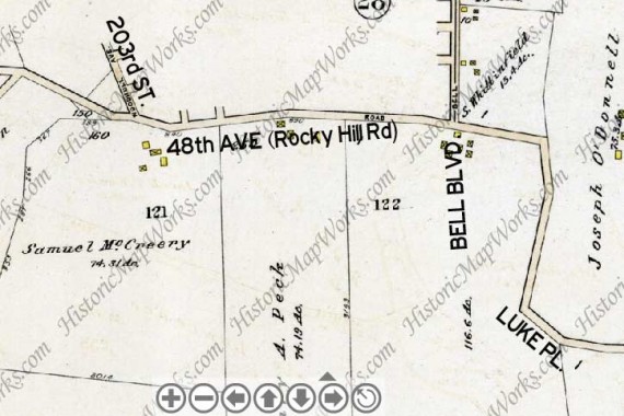
I began tracing old Rocky Hill Road at 56th Avenue, 218th Street and Luke Place. In 1909, Rocky Hill Road followed today’s 56th Avenue, Luke Place, 216th Street amd then turned west along the course of today’s 48th Avenue. I have labeled the 1909 map with today’s street names, and placed a 2010 Google map screen shot next to it.
I became a denizen of Queens in 1993, 84 years after this map was produced, and have lived in eastern Queens — Auburndale and then Little Neck — since then. Eastern Queens is much different from western Queens in that it is widely suburbanized, with wide, sweeping roads and side streets, as well as main roads lined with detached houses with lawns, punctuated by business sections with stores and apartment buildings that formerly marked separate small towns and developments. And when looking at the 1909 map of eastern Queens, with roads stretching across large areas of what must have been farms and fields, I can discern the traces of modern roads — most of the old roads are still there, perhaps slightly rerouted, some with numbered names, some with new names.
In that wide open area of Queens east and south of Auburndale, south of Bayside, northeast of Fresh Meadows, north of Hollis Hills (some maps and realtors call it Oakland Gardens, but that is a specific group of apartments where Springfield Boulevard and the Horace Harding, or Long Island Expressway, come together) there is the usual solid grid of roads, but there are also some roads that can be seen to defy the grid and follow paths all their own. Defying the grid is usually a sign of a much older road, a defunct railroad, or perhaps a separate town. Much of this is in effect here.
Click Gallery for full-size image
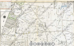
This section of the 1909 Bromley atlas depicts northeast Queens that year. Flushing Cemetery, instituted in 1853, appears upper left, and St. Mary’s Cemetery below it; the Kissena Park Golf Course now fills in the space between. The vanished development called Flushing Heights, now in the Queens College and Pomonok and Electchester Houses area, is center left — some buildings from 1910-1920 survive as Flushing Heights’ legacy. Jamaica Estates, with its winding streets, was mapped out at this time, but still awaited development. Most of this map, though, which is now dominated by the Fresh Meadows housing complex developed by the New York Life Insurance Company in the late 1940s, and by the vast Cunningham Park, developed between 1928 and 1944 (named for 1933-1934 City Comptroller W. Arthur Cunningham).
In the colonial era much of this region was known as Black Stump, after the habit of property owners marking bondaries with blackened tree stumps. Several roads traversed the area, most of which still exist. There is 73rd Avenue, the line stretching west to east near the bottom, formerly Black Stump Road.
The line crossing it running NW to SE has gone by a couple of names through its history, mostly Queens Avenue, but is now known as Hollis Court Boulevard. On today’s map, Hollis Court Boulevard oddly turns up in two separate neighborhoods: southern Auburndale, and again in Bellaire, a couple of miles to the south, between Hillside and Jamaica Avenues. That section of the road, developed in the early 1900s, had a center median and intersected streets called Buckingham and Marlbororough — an English theme repeated in other NYC neighborhoods. The name Hollis Court Boulevard was then applied to much of the rest of Queens Avenue north of Hillside Avenue. An intermediate section in Hollis Hills parallelling the Clearview Expressway was renamed Hollis Hills Terrace in the 1970s, thereby dividing Hollis Court Boulevard in two.
The divided line running through the map marks the route of the old Central Railroad of Long Island, built by entrepreneur/department store magnate Alexander T. Stewart to link Flushing and Garden City (another Stewart development). It operated less than two years — from March 4, 1871-January 1, 1873 — yet it continues to define the street pattern, as the Kissena Corridor Park assumed its old route and Underhill and Peck Avenues run along it, defying the overall grid.
Today’s FNY page, though, concerns the lengthy Rocky Hill Road, which once was a reverse-L shaped road running through most of eastern Queens. It can be seen on the 1909 map as the north-south line on the right side of the map, making a left turn and continuing along the top of the map to Flushing Cemetery. Though today’s Rocky Hill Road only runs three blocks where Auburndale meets Fresh Meadows, it once ran the entire length of this L-shaped road and more. I recently followed it on a 95-degree noontime.
The old route of Rocky Hill Road is presently carried in Bellerose along Braddock Avenue and north of the Grand Central Parkway, by Springfield Boulevard. It was too hot for me to walk that far south. (Do I use Google Earth? You bet I do, and I enjoy it.)
This 1949 Hagstrom Map produced in the postwar period after the area had been built up shows glimmers of that wide-open earlier period. Braddock Avenue is subtitled Rocky Hill Road in parenthesis, and the map still shows some tracks from the CRLI — in the 1940s, there was still a spur from the main line to Creedmoor Hospital.
Braddock Avenue ended, or began, at Jericho Turnpike at about where Cross Island Parkway meets it. Along with Springfield Boulevard (above right, south of Grand Central Parkway) it’s the busiest section of Rocky Hill Road surviving today; on a bike, going from Flushing to Floral Park or Belmont, I always use Braddock because it’s a main route but not pedal to the metal with truck traffic.
Luke Place, looking east toward 56th Avenue. Several handsome colonial-style homes can be found along the route
Though we’re a little south of Bayside at Luke Place and 216th Street, the Colonial Church of Bayside, built in 1939, holds forth at the corner.
Our ministry at the Colonial Church began in 1938. Prior to that year, there was no protestant church south of Northern Boulevard. [I’m not sure about that. — your webmaster]
The Queens Federation of Churches proposed that one be formed. With the help of the Rev. M. Eugene Flipse and the Rev. Charles E. Wideman, houses were canvassed and two hundred fifty eight people petitioned the Reformed church to establish a congregation.
A committee, selected from the signers of the petition, met at the home of Mr. Frank Pond on October 7, 1938, and began the work of organizing the new church. The first worship service was held in the home of Mr. W.W. Webb with Rev. Charles E. Wideman officiating.
In 1937 and 1938, our country was just emerging from a severe depression. The founders of our church had to work very hard to raise money to make our church a reality. Dedication and a strong “team spirit” allowed money to be raised through teas, dinners, dances and fairs. Most of the carpentry, painting, landscaping and cement work exist today because of the that same “team spirit” and dedication. On June 18, 1939, the groundbreaking ceremony took place on church property. A little less than six months later, seven hundred people were in and outside the church for the memorable dedication service. Colonial Church of Bayside
When I last checked the Bayside Hills clock at Bell Boulevard and 53rd Avenue in 2007, it had been vandalized and was out of commission — I’m happy to see that it has been fully restored.
216th Street, formerly Rocky Hill Road, runs south from 48th Avenue to Luke Place and the Colonial Church. The Q27 bus follows much of Rocky Hill Road’s course, and the buses were running frequently today — If I needed one, of course, I’d never see one.
Dermody Triangle
Rocky Hill Road is old enough to have its own Civil War mounument at the point here it curves west from 216th Street onto the path now taken by 48th Avenue. Once again from my Bayside Hills page:
At the triangle park formed by the split, you’ll see a large uneven boulder in the center, inscribed “For a Better Union 1861-1865.” The triangle honors Captain William Dermody, an outspoken abolitionist who was mortally wounded at the Civil War Battle of Spotsylvania, VA in May 1864.
This is the site of one of NYC’s oldest war memorials. The stone was placed here in 1866, when
…this site was dedicated to the memory of Captain Dermody by a ceremonial meeting of a Union and Confederate veteran, each planting a special tree: a maple to represent the North and a sycamore to represent the South. The trees were to grow together as a symbol of the communal hope for a better union. To this effect, a monument was placed in the square with the inscription “For a Better Union 1861-1865,” which remains there today. Every Memorial Day, the Bayside Historical Society lays a wreath at the park to commemorate Captain Dermody and those who fought in the Civil War. NYC Parks
The Rocky Hill Terrace Houses, 48th Avenue east of 215th Street, is a canny tribute to 48th Avenue’s former name, Rocky Hill Road.
From this point Rocky Hill Road went generally westward. Its route was assumed, decades ago, by the present 48th and 47th Avenues, with a short section in between, as we’ll see, that still carries the old name.
West of the Colonial Church, we’re in Bayside Hills, really the southern section of Bayside. I detoured down Bell Boulevard, which here is a pleasant 4-lane roadway with a grassy divider and well-kept homes with lush green lawns. As I mentioned on my Bayside Hills FNY page,
Bell Boulevard takes on a decidedly suburban character between 48th Avenue and the Long Island Expressway, with a center median and plenty of street trees.
The road does not honor Alexander Graham Bell, as many suspect, but shipping merchant Abraham Bell, who purchased about 250 acres in what is now Bayside in 1824. Bell Boulevard (at first named Bell Avenue) was once the dividing line between his two farms. Bell’s mansion on Bell Blvd. and 39th Avenue remained standing until 1971, when it gave way to a building now home to a Tiger Schulman judo school.
Bayside Carlton Cards in what appears to be a classic 1930s- or 1940s style building front ay 48th Avenue and Bell Boulevard. Here is one of the new-style bus stop signs.
Though 48th Avenue runs straight past 212th Street, it wobbles and weaves in other spots — an indicator that it is an older road. Attached brick buildings, one of which is home to the Towne Tavern, line the north side of the road.
Keil Brothers, on 48th Avenue and 211th, is a longstanding plant nursery center established in the Bayside Hills area in 1930. In the colonial era on to the turn of the 20th Century, Flushing, further west, was home to a number of large plant nurseries and wholesalers — Flushing’s plant street naming scheme is a testimony to that.
Love of God Church, a Korean congregation, built this church at 48th Avenue and Oceania Street in 1997.
Oceania Street runs in nearly a straight line from Northern Boulevard south to 210th Street south of the Horace Harding (Long Island) Expressway and replaces 209th Street in the street grid. Since it’s in the center of Queens and nowhere near any ocean, I’ve always been perplexed about the name, which likely comes from a former real estate development. Perhaps they were fans of the 1949 George Orwell prophetic novel 1984, which takes place in a fictional totalitarian state called Oceania, or perhaps, had relatives in the southwest Pacific Ocean, whose many islands have sometimes been grouped as a geopolitcal unit under the name Oceania. Probably neither.
Just east of the Clearview Expressway some of 48th Avenue/Rocky Hill Road’s ancient character leaches out just a little. Some flat-roofed buildings and A-roofed homes are likely very old, as most homes are built with a few steps in front; these are heavily re-sided, making their age unapparent.
I had thought that the Trinity Baptist Church of Bayside (again, we’re more Bayside Hills here than Bayside) was older than it is, but the stone indicates it was built in 1978. This is part of an old neighborhood once known as Clear Springs.
The Metropolitan Transit Authority has resorted to hi-tech options to indicate cessation of weekend service on the Q31.
Constantine’s Deli,east of the Clearview, has been here since 1931.
A quirk in the Queens streeet grid between the Clearview Expressway and 201st Street is actually south of 47th and north of 48th Avenues — permitting Rocky Hill Road to keep its old name here. Rocky Hill Condominiums, on the south side of the road, takes advantage of this ‘anomaly.’
Weeks Lane
Our 1909 Bromley atlas shows a meandering lane running northeast from Queens Avenue, now Hollis Court Boulevard, to Rocky Hill Road. Amazingly, all the roads on this map are still there in their original configurations — just the names have changed. Though Weeks Lane is not specifically named, it undoubtedly too the name because it was near the propety of Jacob Weeks; Lawrence Road, now 50th Avenue, bordered Lawrence property. The Lawrences are an old Queens name and two small cemeteries in the borough, one in Astoria and another in Bayside, are privately held by the family. As we’ll see, even that bend in the road shown on Rocky Hill Road near Hollis Court Blvd. is still there. The small yelllow boxes on the map show houses and dwellings.
In 2010 Weeks Lane can be found just exactly where the 1909 map showed it. The stretch between Rocky Hill Road and Francis Lewis Boulevard contains a classic sidewalk sign for Rainbow Cleaners and a colorful mural for a Thai restaurant.

