What do an obscure alley on the west end of Greenwich Village and a century-old subway mosaic have in common? Plenty, as it turns out. I wouldn’t bring it up otherwise…
(Click on either image above for a larger view)
When the IRT and BMT engineers built subways between 1904 and 1928, under the guiding artistic hands of architects Heins and LaFarge and later, Squire Vickers they did so with not only a keen sense of design but also a dedication to history. Station after station features mosaic and terra cotta representations of not only landmarks that existed at the time they were built (many have since been razed) but also landmarks that had long disappeared.
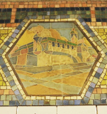
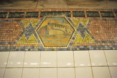
Such is the case at Christopher Street/Sheridan Square, which features a somewhat daunting-looking building with high walls and two towers, one taller than the other.

The plaques, likely the work of Jay Van Everen or Herbert Dole, according to the indispensable Subway Ceramics by Lee Stookey, depict the old Newgate Prison, which stood in the West Village between 1797 and about 1828 at the Hudson River shoreline, bordered by Washington, Christopher and just south of where Perry Street would later appear. Newgate was NY State’s first penitentiary, and pioneered radical correctional policies such as allowing prisoners light in their cells, water to bathe, no corporal punishment, visits from families, and rehabilitational training. By the late 1820s, the prison was no longer isolated and was surrounded by streets and businesses, and transferred to Ossining in Westchester County, the prison known popularly as Sing Sing (land on which the prison was built was called Sintsink by the Indians).
For more on ceramic art in NYC see Tiles in New York.

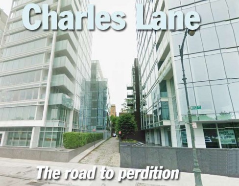
Only one tangible remnant of the Newgate Prison still exists today, the narrow, sidewalk-absented Charles Lane, which marked the northern boundary of the prison property. It appears on this 1885 map, but the City officially mapped it on official records beginning in 1893, when it gained its unusual brick paving.
Charles and Christopher Streets are named for the same man, Charles Christopher Amos, a landowner who had inherited part of Sir Peter warren’s massive Greenwich Village estate in the colonial era. Unusually, the streets were named Christopher, Amos, Charles going north; Amos was renamed West 10th Street as far back as the 1840s.
A Drips Atlas map from the 1850s shows an unnamed laneway where Charles Lane would later appear.
Famed photographer Berenice Abbott shot a photo of a garbage-strewn Charles Lane in the 1930s. The old West Side Highway looms in the distance. The same brick pavement arrangement still exists here. Some of Charles Lane’s one and two-story structures were originally constructed as stables.
In the late 20th Century, Charles Lane was home to drugs and prostitution as many back alleys are. Only in the last couple of decades has Charles Lane gained an aura of quiet quaintness.
Charles Lane’s brick pavement is laid out horizontally with 3 rows of vertically paved bricks in the middle. This was probably done to aid drainage to the gutter on West Street.
A 2012 view. The same brick structures on the right appear in the Abbott photo.
Looking east from about twenty feet from West Street. The buildings on the right are part of the 1974 West Village Houses complex.
Colorful murals and painted bricks on the east side of Charles Lane
13 Charles Lane, a former stable
The west end of Charles Lane was irrevocably altered in 2002 and again in 2006 when this pair of Richard Meier-designed glass front apartment houses arrived. The narrow brick width of Charles Lane between the two buildings is a little bit of 1820 in the midst of a whole lotta 21st Century.
Further: Ephemeral New York, Greenwich Village Society for Historic Preservation.
Charles Lane is not to be confused with the journalist or the longtime character actor.
11/30/12


