

I return to Port Richmond frequently — it’s New York City’s version of one of those innumerable small towns around the country whose downtowns have been Wal-Marted to death, as described in James Kunstler‘s sociological-urban studies books such as The Geography of Nowhere. Port Richmond, once the crown jewel of Staten Island’s industrial North Shore, embodies Kunstler’s manifesto…
James Howard Kunstler says he wrote The Geography of Nowhere, “Because I believe a lot of people share my feelings about the tragic landscape of highway strips, parking lots, housing tracts, mega-malls, junked cities, and ravaged countryside that makes up the everyday environment where most Americans live and work.”
Staten Island’s North Shore once employed thousands along its docks, factories, shipbuilding plants, and factories. The nation’s supply of Ivory Soap was once made in Port Ivory, just a mile or so west of Port Richmond. Those workers and their families made their homes in places like Elm Park, Livingston, Mariners’ Harbor and Port Richmond. They shopped in stores along Richmond Avenue such as Lobell’s and attended vaudeville shows, movies and much, much later, rock concerts at the Ritz Theater. They caught the ferry to the city by riding the North Shore branch of the Staten Island Rapid Transit.
The factories and docks were closed, one by one, the railroad was shuttered as early as 1953, and by the time I discovered Port Richmond via a bus from Bay Ridge in the 1960s after the Verrazano-Narrows Bridge opened, things were already going downhill. The opening of the Staten Island Mall in 1973, a short distance from Port Richmond by bus (Staten Islanders, unlike the rest of New York City, had relied on cars as early as the 1920s) greased the skids and Port Richmond ceased to be one of the island’s main hubs.


This is a Beers atlas plate from 1873 depicting the Port Richmond street layout. The southwest has since been laid out, but other than that, the plan is still the same, centered around the shore-hugging Richmond Terrace, then called Shore Road, and Richmond Street, now called Port Richmond Avenue. Most of the street names, though, have survived to the present, even Avenue B, which has gotten along nicely without an A or a C.


I have never found Richmond Terrace anything but fascinating. There has been a road running along the North Shore of Staten Island since the early 1700s; along with Richmond Turnpike, now Victory Boulevard, it was considered the main road from Staten Island and ultimately NYC to Philadelphia, employing a number of ferries along the way to cross channels and rivers. In 2006, I walked the entire length of the road and recorded what I found there.
Returning in 2014, I have found not a great deal of change in the Port Richmond area except general deterioration. This storefront used to be the headquarters of the Golden Strikers Motorcycle Club, which has moved to a different location in town.


I’m unsure when the Port Richmond to Bergen Point Ferry was instituted, but regular service ended in 1931 with the construction of the Bayonne Bridge the same year, though there was sporadic service until 1961. This postcard depicts the Port Richmond entrance around 1900, give or take a couple of years. Amazingly, a large iron arrow sign remains here over 80 years after the ferry’s demise; the words “Bayonne Ferry” can still be faintly made out.


There’s always Mom and despite the downhill slide of the rest of Port Richmond, or perhaps because of it, there’s been a liquor store here on this spot for many years — that’s a vintage hanging shingle neon sign that looks at least 1940s vintage. New York Neon claims it for 1935.


Though many of Port Richmond’s industrial businesses didn’t make it out of the 1970s, H.S. Farrell survived all the way to 2009, occupying several buildings on Richmond Terrace, including the double-towered former Empire Theater, open for its original purpose until 1978, though it spent its final theater years as a porno palace. The raincoat brigade was replaced by a great deal of wood. Ultimately, a storefront church has claimed the space.
H.S. Farrell Lumber and Millwork began as the Alvin Conklin Planing Mill in 1888. It was a physically demanding hands-on enterprise exclusively operated by men.
The venture hit its first major milestone in 1912, when Harry Farrell, who was Conklin’s nephew, bought the mill. Two years later, the new owner changed the company name to H.S. Farrell Lumber and Millwork, but it wasn’t until shortly before Farrell’s untimely death, 24 years later, that the business expanded its scope.
Farrell’s widow, Marion, who up until then had been the mill’s bookkeeper, broke tradition and took command of the business. Her action did more than ensure the mill’s continuation; it highlighted the competency of women entrepreneurs and paved the way for her sons, Robert and Donald, to step into the venture. SI Live


The older sections of Staten Island contain a number of cul-de-sacs and dead-end alleys, too innumerable to really include all of them on my Alleys category pages. Jutting north from Richmond Terrace just west of Port Richmond Avenue is Ferry Street, which is home to the Flag Container Service but has a hidden tributary alley of its own in Gales Lane, which is still on the maps, but obscured behind a red, white and blue fence.


Port Richmond Avenue
This brings me to that little piece of Port Richmond Avenue that juts north to the Kill Van Kull from Richmond Terrace. Clearly, there’s a lot to be seen here, but first, I want to provide you with a word or two to the wise.
On an early January Sunday, I got on a LIRR train from Little Neck, took a #1 train from Penn Station south to the ferry, grabbed the ferry across Upper New York Bay, boarded the R-40 bus from the ferry terminal, and 2:45 later, alighted in beautiful downtown Port Richmond. Whereupon my camera battery expired, since I had forgotten to recharge it. My camera model doesn’t take batteries, but even it it did, I really needed a Radio Shack to sell me lithiums because you can shoot about 40 photos with plain old regular AAs, and I typically get 200 photos per outing — my FNY pages scratch the surface and skim the cream. Stoic but seething, I got the R-40 bus, ferry, #1 train and LIRR back home, as Mr. Loser had lost again. The “takeaway” as the kids say, is that when out “waving the camera around,” take a spare everything, including battery and camera card.
I returned 2 weeks later on a sunnier day and got what you’re seeing here. Like I said, there’s plenty to see in downtown Port Richmond, at the north stub of Port Richmond Avenue. Ultimately this route tacks on about nine extra lanes and roars through the center of the island, bisecting it in two. It is the road that goes past the Staten Island Mall. South of Korean Veterans Parkway, it is calmed to a 4-lane residential road and ends at Raritan Bay. Until the late 1970s, the entire stretch was called Richmond Avenue, but in a last burst of civic pride, the portion between Richmond Terrace and Forest Avenue was renamed Port Richmond Avenue.
I spotted the “street art” mural emblazoned “City of Dreams”; could the artist mean Port Richmond, or NYC as a whole? The abandoned mattress, the first object found on the avenue, with the Kill Van Kull, abandoned ferry and Bayonne, NJ in the background; the lone surviving mooring bollard — perhaps this was once a mooring slip similar to the “slips” in lower Manhattan; and the Island Live Poultry Market.


Undoubtedly though, the highlight of this forlorn dead end, where I have come in dead January, are the battered remains of the Philip T. Feeney tug moored here. I also couldn’t resist the “life is beutiful” [sic] graffito on the overhanging rock. This isn’t an extensive ship graveyard like the one found in Rossville on the island’s south shore, but somehow one abandoned wreck is more poignant than dozens of them.
Citynoise, which has an extensive photos of the interior, says the tug first saw service in 1892. If anyone has a different date, shoot me something in Comments. As for me, I didn’t want to risk falling into the noisome and noxious Kill, especially in frigid January, but I’m glad someone did.
This is the remains of the tug Philip T. Feeney. Built in 1892 by the Bethlehem Steel Company in Sparrows Point, MD, the tug worked the Erie Canal. Originally built with steam power, it was retrofitted with a diesel engine in the 1940s.


You might not associate Aaron Burr, Thomas Jefferson’s Vice President (though not his running mate) and the killer of Alexander Hamilton while still in office, with Staten Island. However, he did live on the island, on Richmond Terrace just north of this lengthy brick building on the east side of Port Richmond Avenue between Richmond Terrace and Church Street. It was built in 1874 for Charles Griffith, a boot and shoe dealer. Directly abutting it on Richmond Terrace was an 18th Century private residence, in its later days called the St. James Hotel, known to be the last home of Burr before his death; that building was demolished in 1945.


Across the street, on the west side of Port Richmond Avenue, are a pair of buildings likely built in the 1880s or so that were associated with the Staten Island National Bank. A ghost sign on the Port Richmond Avenue side advertises a former connection with the Chase Manhattan bank. I zoomed in on the old burglar alarm and night depository slot. Another ghost sign on Richmond Terrace indicates it was once a drive-up bank as well. According to Scripophily, Staten Island National Bank was established in 1902 as the Port Richmond National Bank and merged with Chase in 1957. Ape Shall Not Kill Ape has a couple of vintage photos of the building.


These fake ads fooled me at first. This stretch of Port Richmond Avenue has been characterized in the past by a plethora of superannuated awning signs of long-vanished businesses, so I thought that these were similarly ancient and had been uncovered. I’m 95% convinced they were placed there as props for a film shoot, since shows like Boardwalk Empire have filmed extensively on the island; Empire props left in Richmondtown a couple of years were similarly convincing.


For example this carefully woodcarved ornamented pediment, which says “Erected 1885,” is indeed the real deal; I noticed it several years ago. In Port Richmond, the ancient and the fake ancient are intermingled and eventually, if untouched, it’ll be hard to tear them apart.
But if it’s ancient you want…here’s a remnant of the first European settlement at what became Port Richmond, in the late 1600s:


Dutch Reformed Church Cemetery
Dutch Reformed Church Cemetery, established in 1696, is the oldest burial ground in Staten Island, and is in the top ten oldest in the city; Prospect Cemetery in Jamaica, Queens (1668), downtown’s Trinity Cemetery and the Shearith Israel Cemetery on St. James Place in Chinatown are also on the list. (Gravesend Cemetery [1650] is the oldest, says historian Joseph Ditta.) Originally it was the private burial ground of the Corson family, which owned a great deal of what became Port Richmond in the early colonial days. Interments continued in the cemetery until the city banned further ones on a spurious health basis in 1910. Family members of previously owned plots continued to be buried there until the 1930s. The oldest remaining gravestone is from 1746.
To read the cemetery headstones is to read a street map of Staten Island, with Corsons, Crusers, Van Names, Burghers, DeHarts, Haughwouts, Latourettes, Mersereaus, Zeluffs, and numerous other families represented. In the colonial era Staten Island was settled by the Dutch and later by Belgians of French extraction known as Walloons and also by French Protestants known as Huguenots who were expelled from France due to their religious choice.
Several veterans of the American Revolution are here, including Major William Gifford (1750-1840) an aide de camp of George Washington. His grave is under the sidewalk in front of the Dutch Reformed Church. Brown sandstone monuments from the 18th Century feature older death’s head apices but also the latterday ones with cheerful cherub tops. Some are in the Dutch language, though not as many as at the Flatbush Dutch Reformed Church, which also originated in the 1690s. Ironically the older sandstone gravestones are more easily read than the later ones in marble, that succumb more easily to rain, wind and pollution.


The present Greek Revival Staten Island Reformed Church was constructed in 1844 and replaced two earlier churches on this site — the first one was chartered as early as 1696.
The church’s congregation is the oldest in Staten Island and its first church <building was erected on this site in 1715. The present church is the congregation’s third; it is the oldest church building on the North Shore and one of the oldest churches on Staten Island.The church’s graveyard is the oldest non-private cemetery inStaten Island. NYC Landmarks Preservation Commission Report


The south end of the Reformed Church is a relatively recent addition. It was built in 1898 as a Sunday school and chapel addition. The 2nd and 3rd sections of the cemetery adjoin the “new” wing; some interments were transferred to the 2nd and 3rd sections when Port Richmond Avenue was widened.


From the 1880s to 1953 there was a North Shore branch of Staten Island Rapid Transit, which of course included a stop at Port Richmond. The railroad eliminated grade crossings here in the 1930s, with the railroad placed on a concrete and metal trestle. I have some views of this from the elevated station itself on FNY’s Staten Island Rapid Transit page from way back in 1999.

Port Richmond features a number of “named” buildings; in what was considered a “prestige” neighborhood, there was pride of place, and developers and owners placed their names front and center, like with the Leo Building.


A well-worn fire alarm box bears a sticker saying “Keep the Alarm Boxes”; periodically, there’s a push to remove all fire call boxes in the age of cell phones. RIGHT: one of the leftover stanchions from a late 1970s urban renewal protects that also included lampposts and paved street crossings, in a last ditch attempt to keep shoppers in Port Richmond and not the Staten Island Mall. Some of the light stanchions and signs remain.

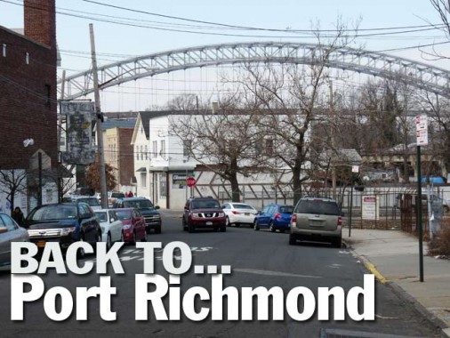
The Bayonne Bridge, completed in 1931, provides a picturesque backdrop for many of port Richmond’s east-west streets. The bridge has a walkway, which I navigated in the summer of 2012.


The former State Bank of Richmond County, Port Richmond Avenue and New Street. Once again, according to Scripophily, as early as 1930 it merged with State Brooklyn Trust; after a series of mergers, it’s part of JP Morgan Chase. The building was lately a Syrian Orthodox Church, but seems to be vacant these days.

C. H. Martin department store. The sign looks like a “hangman” game… four letters have now fallen off the ancient awning sign. C. H. Martin is actually a chain, but oddly the website doesn’t list the Staten Island location; my guess is that whoever is there now hasn’t bothered to maintain the sign.


Here’s another of those decorative pediments, displaying the otherwise-forgotten developer or architect V. Portrera.

This building with the handsome facade at Port Richmond and Castleton Avenues was constructed for Albert Nordenholz in 1922; his name appears on the cornice. In its early years it hosted the Richmond County Savings Bank, which merged with Ironbound Bank in 1999 and after a series of mergers became NYS Community Bank.


Next door, 226 Port Richmond Avenue (the Mutual Building) also built for Nordenholz in 1922. Of interest is the nameplate with a pair of, most likely, former tenants.

The magnificently-Ionic-columned CYO Center at Park Avenue and Anderson Street just off Port Richmond Avenue. This was once a Masonic temple, but it serves now as a community center and HQ for the local Catholic Youth Organization, ironic since the Masons and the Catholic Church have been traditional opponents.

The former Ritz Theater, Port Richmond Avenue and Anderson Street. It was opened in 1924 and employed as a movie theatre, concert venue, and roller skating rink till 1985, when it was converted to a bathroom tile showroom. The Ritz, according to legend, launched the career of Jerry Lewis, who did a comedy act here in 1942 and was signed to a contract soon after.
In what’s something of a lost chapter in rock history, from 1970 to 1972 the Ritz (which held 2,126 seats) — and other ‘outer-borough’ venues such as the Loew’s 46th Street Theatre (renamed the 46th Street Rock Palace) in Borough Park, Brooklyn, where the Grateful Dead once played a 2:30PM Wednesday afternoon show! — featured some of the world’s biggest rock bands at the height of their popularity.
Alice Cooper, Badfinger, Captain Beefheart, Black Sabbath, Iggy and the Stooges and Deep Purple all played the Ritz in the early 1970s, when they were touring behind such albums as School’s Out, Straight Up, Paranoid and Machine Head. Other bands that stopped by the Ritz were the MC5, Mountain, the Allman Brothers, Edgar Winter, the Kinks, Yes (the last two a double bill), Humble Pie, King Crimson, Uriah Heep, Canned Heat, the Chambers Brothers, Three Dog Night, the Hollies, and a post-Jim Morrison Doors. The shows were booked by brothers Arnie and Nicky Ungano, who also had their own concert venue, Unganos, for awhile on West 70th Street on the Upper West Side.
A commenter on Cinematreasures: The Ritz concerts did not last to due ‘contract riders’ put into place in the early seventies by NYC concert promoters. They insisted that the musicians performing at their place could not book additional shows within a 50 mile radius of the venue nor within a month surrrounding the show. This essentially killed the bookings for national recording acts at the Ritz Theater.
The Ritz, the 46th Street (Brooklyn) Rock Palace, and latterday venues such as L’Amour in Bensonhurst, Brooklyn, should all be given a place in the Rock and Roll Hall of Fame — as a missing chapter in rock history.
Coming soon… more Port Richmond. Well-worn territory for me, for sure, but I see something new that’s old every time I’m here.
6/16/14