I got off the #1 uptown at 225th Street and wasn’t sure where I was going, which some say has been my problem all these years. I would up lollygagging around Kingsbridge Heights, Fordham, Bedford Park and Norwood, even briefly entering Woodlawn Cemetery before returning to town via the D train at the end of the line at 205th Street. As Joe Raskin explains in The Routes Not Taken, the IND was originally supposed to keep going east all the way to Baychester under Burke Avenue. We can say with some certainty now that such a handy subway line will now never be built, and if you really want to get around, the best way is to put one foot in front of the other, like me.

I didn’t spend much time in Marble Hill, since West 225th Street heads east through a couple of shopping centers and bridges over the NY Central Putnam Branch tracks (now used for layups only) and the Major Deegan Expressway.
You know one advantage that the old printed maps from Hagstrom, Rand McNally, etc have over Google Maps? They show borough boundaries. For example walking east on West 225th takes you from Manhattan over the Bronx borderline, which is between Broadway and Exterior Street. Google Maps, as far as I can tell, doesn’t show town, borough, city, state or even country boundary lines.
West 225th keeps its name until it crosses the Major Deegan, and then becomes West Kingsbridge Road, one of the Bronx’ hilliest paths. The road and the neighborhoods of Kingsbridge and Kingsbridge Heights are named for a vanished bridge that once crossed Spuyten Duyvil Creek where the Bronx-Manhattan line now is on Marble Hill/Kingsbridge Avenues in Marble Hill.
Frederick Philipse built the first King’s Bridge, a tolled span over Spuyten Duyvil Creek, in 1693. Benjamin Palmer and Jacob Dyckman built a second bridge in 1759 to avoid paying the high tolls charged by Philipse. During his retreat from the Battle of Harlem Heights in 1776, General George Washington used both the King’s Bridge and Palmer and Dyckman’s free bridge to escape to White Plains. The original King’s Bridge has inspired a network of roads in Manhattan and the Bronx, some surviving, some not, named for it. The span survived till the excavations for the Harlem Ship Canal between 1913 and 1916.
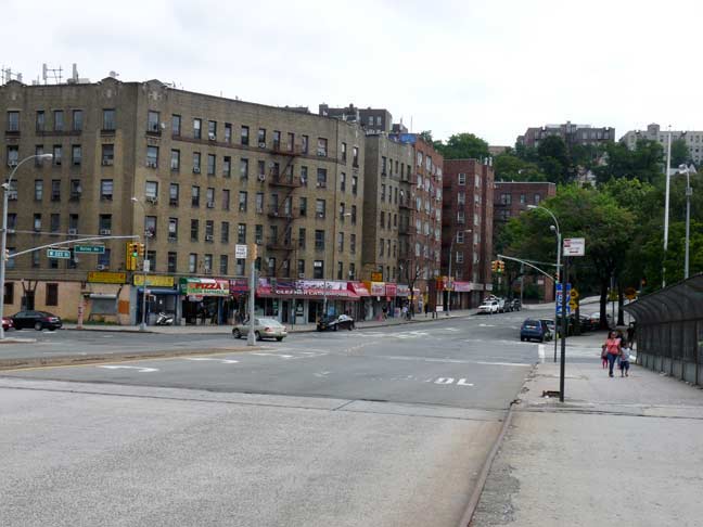
The above scene shows the very spot where West 225th becomes West Kingsbridge Road. The road bends and twists its way around several hills in this part of the Bronx. It goes back to the colonial era, and before that, it was a Native American footpath. The northern part of Broadway in Manhattan was once also called Kingsbridge Road, and it connected to this section via the old King’s Bridge.
Much more can be found at The Names of the Neighborhoods of The Bronx.
GOOGLE MAP: MARBLE HILL TO NORWOOD
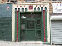
Trudging up West Kingsbridge Road between Bailey Avenue and Kingsbridge Terrace in Kingsbridge Heights, I found a couple of old doyennes still on the resuscitator, a beautifully rendered terra cotta apartment building entrance, and a Neo-Moderne classic, all blond brick and sharp edges where you could probably cut yourself.
The Bronx is the Borough of Apartment Buildings. In the early 20th Century, these multifamily buildings like this pair at West Kingsbridge Road and Webb Avenue were constructed with flourishes, such as beautifully patterned brickwork and beige paneling.
I try to make a note of every hand-lettered sign I see wherever I go. This one has done the job for a couple of decades, at least.
The Bronx is notable for its apartment building facades that curve at intersections, and even the curbline is curving here at W. Kingsbridge Road and University Avenue. Though there are a few of these in other boroughs, the Bronx is especially notable for them, and I have no explanation why — except that some streets don’t meet each other at perfect right angles, and some developers and architects decided to curve their buildings to match the curbline, and after that a lot of copycats took up the cause.
The Kingsbridge Armory makes quite the impression as you continue east toward the Jerome Avenue El. It was at one time considered a prime NYC tourist attraction: in its tourist heyday in the 40s and 50s it was home to bicycle races and boat shows, and was even advertised in “Subway Sun” public service ads on the trains.
The Armory was built from 1912-1917 by architectural firm Pilcher and Tachau as a munitions storage area; when built, it supposedly was the largest armory in the world. The interior dirt drill deck measured 300×600 feet. The Armory housed the 258th Field Artillery; the unit has its roots as a military escort for George Washington at his first inauguration. The best views are from Kingsbridge Road, but it also looms impressively over Davidson Avenue as you approach it from the south.
Every few years, you hear about the Armory being redeveloped for something like a school or a shopping mall. The latest [August 2014] calls for a 5,000-seat ice arena with several separate rinks. Perhaps the Ice Capades will come to the Bronx and maybe even one of the local hockey teams could make an appearance, if this plan doesn’t melt down like the others have.
West Kingsbridge Road intersects Aqueduct Avenue West and Aqueduct Walk, both of which accompany the course of the old Croton Aqueduct, which ran from upstate New York to the former Croton Reservoir, which was located on 5th avenue and West 42nd Street. The reservoir was replaced by the New York Public Library main branch in 1912. The aqueduct ran on High Bridge over the Harlem River, which in 2014 was being restored to walkable condition with a spring 2015 reopening hoped for.
Here’s an odd occurrence of Bronx street nomenclature. Aqueduct Avenue East runs from West 180th Street north to West 184th Street, and Aqueduct Avenue West from West 188th north to Kingsbridge Road. Why is Aqueduct Avenue West in fact north of Aqueduct Avenue East?
The answer is simple. Aqueduct Avenue West is west of the former aqueduct, while Aqueduct Avenue East is east of it. What’s confusing is that the two avenues are not directly parallel.
Packed storefront opposite the Armory. Remember when 1 Hour Photo was a big deal? Now most people pretty much have Instantaneous Photo. I don’t have a phone camera, I use an actual camera, so I do wait till I get home and plug the card into my desktop.
I do miss the tactility of things, the movie cameras, reels of film, actual photographs on paper, slides, LPs, CDs, even old fashioned flashbulb cameras. There’s the magic box with the pictures on it that you talk into and poke with your thumbs. Soon, even that will disappear and images will be projected onto Google Glass™ or Google Contact Lens™. To call someone you’ll push a button on your shirt, or one embedded in your skin. Or your thoughts will be sent via satellite.
Another styled apartment building, this one on East Kingsbridge Road and Morris Avenue.
Old school street art on Morris Avenue south of East Kingsbridge. Charles Bronson, likely in his Death Wish role, and the destroyed Twin Towers are depicted.
I can’t talk about the insides, but here’s a near-perfect set of attached brick houses with porches, each painted a different color, on Morris Avenue, right next to the street art.
East Kingsbridge Road widens somewhat and passes under the Grand Concourse in a tunnel, as do several other cross streets. For several decades these were used by trolley lines to escape the traffic on the Conk, which was built along a ridge in the western Bronx in 1909. The trolley lines may have already been present — my trolley research in Brooklyn surpasses that of the other boroughs, sad to say, and the ramps may have been originally built to carry wagon traffic under the multi-laned boulevard.
I have walked the Grand Concourse a number of times. Eleven lanes wide from 161st Street north to Mosholu Parkway, the Grand Boulevard and Concourse (shortened to Grand Concourse for the benefit of sign makers and cabbies) was conceived by French engineer Louis Risse in 1870 and was built, from 161st Street north, in 1909. In 1927, it absorbed Mott Avenue, which ran from 138th north to 161st, and the older street was widened. The Grand Concourse became the Bronx’s showpiece as the Bronx Borough Hall, Yankee Stadium, and an array of elegant apartment buildings were constructed along its length.
Passing the Conk on Kingsbridge Road is impossible without mentioning Poe Park and the cottage where the genius, yet troubled and alcoholic writer Edgar Allan Poe lived in a small house, meticulously preserved by NYC Parks. From the Grand Concourse page linked above:
When Poe lived in this small farmhouse at the Concourse and East Kingsbridge Road with his wife Virginia (a first cousin) and her mother between 1846 and 1849, there was no Grand Concourse, and the house stood far out in the country. That’s what Poe was seeking in a dwelling, believing the clear country air would invigorate his ailing young wife, who had tuberculosis. Tragically, it did not work and Virginia died; one of his best-known poems, “Annabel Lee”, is thought to memorialize her.
Poe and his family were destitute while living in the farmhouse. He was a literary success but had lost his savings in a failed magazine venture. The author and his mother-in-law had to forage in nearby fields for the family’s sustenance. The cottage itself was built in 1812 by farmer John Wheeler and stood on Kingsbridge Road until it was moved to its present location in 1913.
The house is one of four Poe museums in the USA; it is sparsely furnished in the fashion Poe must have had while here. It is thought that the bed, gold-framed mirror and rocking chair belonged to Poe himself.
I was surprised to see that in recent renovations, a couple of panels bearing Poe’s signature were placed on the fence around the park.
A tree reduced now to a stump in Poe Park was planted to honor Lt. Monroe D. Franklin, killed in WWII action in the Philippines in 1942.
You can see signs in any language in NYC. This one is partly in Khmer, or Cambodian script, while Battambang is Cambodia’s second-largest city with a population of 140,000.
A pair of what were once masterworks along East Kingsbridge Road between Valentine and Briggs, one Beaux-Arts and one Deco, with probably 15 years difference between them. By now the interiors are probably nothing to get excited about, but the outsides were executed with the brio for which the Grand Concourse-area apartment buildings are famed.
I’ve given Coles Lane and its satellite, Poe Place, the Forgotten NY treatment they deserve in a previous post and I have nothing much to add here, except that here is the odd occurrence of one dead-end alley that’s intersected by another. Coles Lane faces Bainbridge Avenue, though it’s accessible by steps from East Kingsbridge Road, and Poe Place emanates from Coles Lane.
Fordham Public Library building, 2556 Bainbridge, facing Coles Lane, was slated to be transformed into an animal shelter in 2008 despite community opposition; it has stood empty after it closed in 2005.
I turned left here, going north on Bainbridge Avenue, which after a trickling southern end becomes one of the main spines of Norwood. The street was named for Commodore William Bainbridge (1774-1833) who commanded the USS Constitution during the War of 1812.
A stolid brick apartment building on Bainbridge Avenue and East 193rd Street. I grew up in one of these buildings in Brooklyn; there are hundreds dotted around at least 4 boroughs, and even Staten Island has a few.
Four Corners Hardware, with two now-fading handlettered signs, occupies the SE corner of Bainbridge and East 194th.
Street art on the northeast corner.
I haven’t much to say about these private houses, probably 2 families each, along Bainbridge Avenue between East 194th and 198th, except that I like them, especially the double porched houses, one porch for each floor. Because no matter if you’re on the first or second floor you have a porch, and porches are important.
Most of them have the de rigueur aluminum siding, but a couple stick out, like the one with the stone block construction or the other one with the wraparound porch.
A pair of tableaux that illustrate the complete change in philosophy that happened soon after the turn of the century, when increasing immigrant populations demanded a turn away from small private housing to massive multifamily apartment houses.
I can imagine the owner frantically waving a shotgun at the mad sidewalk scribblers on the sidewalk outside his house.
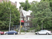
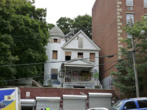
A pair of peaked, turreted houses on East 198th Street and Pond Place, a block east of Bainbridge. The Briggs family was prominent in the Bronx throughout the colonial period and into the 19th Century, and Peter Briggs maintained a farm on this property that contained a pond. When streets were laid out, Pond Place was laid out on the filled-in pond. It was formerly called Ursula Place, after the Ursuline Academy across the street (see below)
The Bronx’ Ursuline Academy (originally the Mount St. Ursula Convent) is an austere building on spacious grounds at 330 Bedford Park Blvd. at Marion Avenue. The academy grounds occupies the block between Bainbridge Avenue, Bedford Park Boulevard, East 198th Street, and Marion Avenue. The Academy of Mount St. Ursula High School, an all-girls prep-school, is located here today. It celebrated its 150th anniversary with the class of 2005.
The Ursulines are a Roman Catholic religious academy founded in 1535 by St. Angela Merici, of Brescia, Italy. Throughout the centuries, Ursuline nuns have been heavily involved in education; the Ursulines originated two Catholic women’s colleges, Ursuline College of Pepper Pike (near Cleveland), Ohio and the College of New Rochelle, NY.
According to a legend that appeared in the tenth century, Ursula was the daughter of a Christian king in Britain and was granted a three year postponement of a marriage she did not wish, to a pagan prince. With ten ladies in waiting, each attended by a thousand maidens, she embarked on a voyage across the North Sea, sailed up the Rhine to Basel, Switzerland, and then went to Rome. On their way back, they were all massacred by pagan Huns at Cologne in about 451 when Ursula refused to marry their chieftain. Catholic Online
Bedford Park
Bedford Park is a Bronx niche lying between Kingsbridge Road on the south, Mosholu Parkway on the north, Jerome Avenue on the west and Webster Avenue/New York Botanical Gardens on the right.
Unlike Brooklyn’s Bedford Avenue, named either for the British town or the Dutch word “bestevaar” (“meeting place of old men”) Bedford Park, Bronx is named for a historical figure: Edward Thomas Bedford, president of the Bank of the State of New York — an associate of Leonard Jerome, the organizer of the Jerome Park racetrack (now a reservoir) and the grandfather of Winston Churchill.
One of Bedford Park’s distinctive apartment buildings, The Bainbridge Court, is on the NE corner of Bedford Park Boulevard (which stands in for 200th Street, as Dyckman Street does in Manhattan) and Bainbridge Avenue. It’s awash in thick corbelling at the roofline, and tasteful terra cotta work.
The Bedford Park Presbyterian Church, a handsome Queen Anne style brick and stone church, was constructed by architect Robert H. Robertson in 1900. Information is sketchy about the church on the World Wide Web, but Bradley Longfield’s book The Presbyterian Controversy: Fundamentalists, Modernists, and Moderates contains some information on one of the first pastors, Henry Sloane Coffin:
The “handsome new edifice” is the building pictured. Henry Sloane Coffin (1877-1954) was the uncle of William Sloane Coffin Jr. (1924-2006), the activist pastor of Riverside Church in Manhattan.
The Bedford Park Presbyterian Church House, next door on Bainbridge Avenue, is a Tudor-ish brick building with red-bordered casement windows and doorways. The wide door on the right may once have admitted horses as a carriage house.
There are signs, and there are signs. These are still found very frequently outside Bronx apartment buildings, though they’re no longer updated. I’ve seen a couple in Brooklyn, as well. Available apartments, and the number of rooms, would be notated on the sign. And how about that lettering? Professionals at work, folks!
Twin-peaked private dwelling that stayed put while apartment houses were built on each side.
Evelyn Arms, with a set of 4 Ionic pilasters flanking the entrance, Bainbridge north of Bedford Park Blvd.
Art Deco streamlined apartment building close by. The year of construction was probably 1929-1932.
Wolf Electrical sign on a building at Bainbridge Avenue and East 201st Street.
More to see on this walk as I go into Norwood and Woodlawn Cemetery, but that will be in Part 2.
10/5/14


