I lived in Bay Ridge between 1957 and 1993; for those who usually don’t have to deal with people born in the 1950s, I am impossibly old now. I became acquainted with area maps beginning in 1968 and have made map collecting, especially street maps and even more especially street maps of New York City, a hobby that brings joy. I liked poring over maps to detect tiny streets, out of the way places that are usually overlooked or ignored. A couple of them happened to be located in Bay Ridge, and both of them, as it happens, are links to the dim past. I have previously discussed Stewart Avenue in Forgotten NY; and today, it’s Forest Place’s turn.

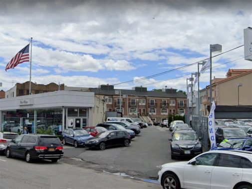
Forest Place runs for one block, diagonally against the overall grid, from 4th Avenue and 89th Street southwest to 90th Street. It is stuck between two car dealerships for Volkswagen and Honda. The short lane is used to park cars that overspill from each dealership’s exterior yards.

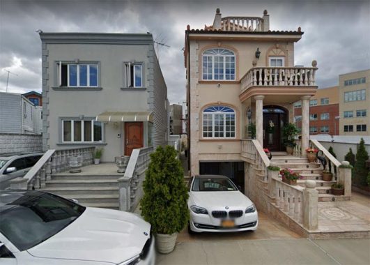
Two properties face the lane, which is without a sidewalk and, as I recall, may have been unpaved during my early years in Bay Ridge. One is #38 Forest Place (left) and the other is #42. As you can see the fronts of both buildings have been renovated in recent years into conditions their owners believe to be appropriate to the times. For reasons unknown, #40 was skipped in the house numbering scheme.

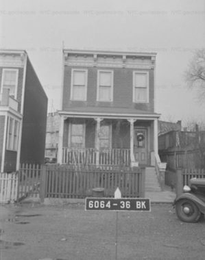
This is #42 Forest Place in 1940 and this is roughly how I remember the building looking when I first encountered it.
Forest Place at 90th Street. In my youth I do not recall Forest Place being equipped with streetlamps and as you can see there are no sidewalks. I also don’t remember street signs, though it has two now, a sun-bleached one here at 90th and a newer one on 4th Avenue. The lights for the car dealer yards, I imagine, provide adequate lighting. Today, Forest Place is used as a shortcut by pedestrians or by residents of its two dwellings; however, I doubt it gets much auto traffic other than the parked cars for sale.
Forest Place is one of Yellow Hook (Bay Ridge’s) oldest thoroughfares. I have excepted this mid-1800s map and marked some of the roads in use then. 3rd Avenue already had a horsecar route from downtown Brooklyn and had already been laid out, but Bay Ridge’s familiar grid was still in the future except for a small network of streets that used to comprise the village of Fort Hamilton. These streets were incorporated into the present grid when it reached this far south. Even today, these streets are a little narrower and some one-story bungalow buildings still exist.
I have marked Forest Place in red. As you can see it used to be somewhat longer, extending south to today’s 91st Street and then east to Stewart Avenue, today’s 5th Avenue. That northern section became 89th Street in subsequent decades.
By the time this 1922 Hagstrom was drawn up the current street grid was in place, at least on paper. This is the way the current map looks, except for the addition of the Gowanus Expressway between Dahlgreen and Gatling Places in the 1960s. And, the red line that indicates the 4th Avenue BMT subway (R train) wouldn’t extend south to 95th Street until 1925. Forest Place has been cut back to the short lane we know today.
Much more on Forest Place in HeyRidge.
Check out the ForgottenBook, take a look at the gift shop, and as always, “comment…as you see fit.”
7/16/20
