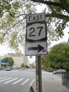
One of these days… months … years I’ll write a Forgotten New York page on all the New York state routes that run along local streets. There are a number of them, but not a sufficient amount to produce a page that’s much too lengthy for me to write, and for you to read. I was stalking around in Prospect Park the other day and after having just left a friend who lives near the park, I spotted this sign on Coney Island Avenue just south of Caton. (OK, I had known about this sign for some time, and check to see if it’s still there every time I’m in the area.)
New York State 27 runs in all four counties on Long Island. It begins at the junction of the Gowanus and Prospect Expressways and has a somewhat convoluted route along the Prospect and Ocean Parkway, then west on Church Avenue, north along East 3rd (East 5th traveling south; side streets are one-way) then east along Caton to its junction with Linden Boulevard, then east along Linden to the Belt Parkway. When the Belt turns north in Rosedale, NY 27 follows Sunrise Highway all the way out to the South Fork and then it mostly follows the Montauk Highway, ending at Montauk Point in the state park of the same name.
NY 27 was designated in 1927 in Nassau and Suffolk Counties, and was extended west into NYC streets in 1934. Its current route along Linden Boulevard, however, wasn’t designated until the 1960s, and after several years extending north to the Holland Tunnel, it was cut back to begin at the Gowanus Expressway in 1973.
For the most part, NY state routes are meaningless in the five boroughs, only gaining importance far outside the city where they serve as main routes absent the presence of interstate or US highways in their vicinity. That, I suppose, is why I enjoy locating them.
Check out the ForgottenBook, take a look at the gift shop, and as always, “comment…as you see fit.”
10/26/20
