“There are more things in heaven and earth, Horatio, than are dreamt of in your philosophy” — Hamlet
In nearly a quarter century of wandering around New York City photographing and researching Forgotten New York, I have come across a few things that are simply unexplainable. Oh, there are no doubt reasons for these objects’ existence, but they have been lost in the sands of time. Now, explanations can be guessed, surmised or grasped at, but proof eludes me. (It’s possible that a little more digging in places I haven’t suspected may lead to more satisfying conclusions.)
Today, I’ll present three streets in three separate boroughs whose naming scheme seems completely unexplainable and arbitrary. I will admit that I have found an explanation for the name of one of these streets after a bit of research, but the other two? Well, as the cliche goes, your guess is as good as mine.

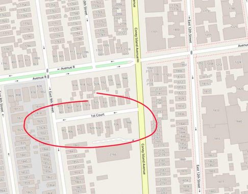
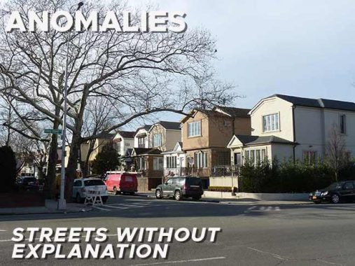
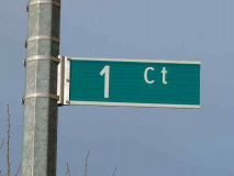
First Court is a one-block passageway between East 9th Street and Coney Island Avenue a block south of Avenue R in sort of a transitional area between Midwood, Sheepshead Bay and Gravesend; atlases call it Homecrest, though I’m not sure if its residents do. 1st Court is actually the pleasantest of the three “anomalies” on today’s page, with a couple dozen well-kept individual houses each on their own plot. It is not followed by a Second Court or a Third Court; it stands alone. The Department of Transportation labels it “1 Ct” on street signs.

It would make more sense, if a numeral were insisted on, that it be called 9th Court, as it is located off of East 9th Street. A look back into historic maps from decades past reveals nothing as the main east-west streets in this region have always carried letter names; Avenue R was never numbered. It doesn’t show up on maps from the 1910s, but I have it on maps from the 1920s and an aerial photo from 1924 shows it in place, so we can determine it was built between 1920 and 1924.
My guess: a real estate developer once determined to build a number of streets between East 9th and Coney Island Avenue, but was forced to stop after building 1st Court.
Manhattan and Brooklyn both have Avenue Bs, but they occur in a sequence, between Avenues A and C (though Brooklyn’s Avenues B amd C are miles apart from each other). Not so in Port Richmond, Staten Island, where Ann Street abruptly turns south, becoming Avenue B, and then continues past Bennett Street to a dead end.
I don’t think this is the result of a long-ago real estate developer’s hubris. Avenue B is a very old street. This is a Beers atlas plate from 1873 depicting the Port Richmond street layout. The southwest has since been laid out, but other than that, the plan is still the same, centered around the shore-hugging Richmond Terrace, then called Shore Road, and Richmond Street, now called Port Richmond Avenue. Note the Eberhard Faber property at the top of the map; the pencil manufacturer, whose factories were in Greenpoint, Brooklyn, had holdings in Port Richmond. Most of the street names, though, have survived to the present, even Avenue B, which has gotten along nicely without an A or a C. It’s possible Cottage Place was called Avenue A at one time; but that time predates this map.
I long pondered the origin of the heretofore mysterious B Street, which runs south to a dead end on Baisley Avenue between Hobart and Edison in Pelham Bay in the Bronx. Thanks to the efforts of ForgottenFan Mike Fornebaio the ‘mystery’ has been solved. It turns out this is one of the oldest streets in the area that has kept its original name, and is one of the keys that unlocks the secrets of this unheralded realm.
In this Gallery, I have placed an excerpt from the 1900 Hyde atlas of the area side by side with Google maps of about the same area. Click on any image for a closer view.
While we think of the Bruckner Expressway as a mid-1900s modern thoroughfare, it pretty much follows the path of Eastern Boulevard in a reverse-L shape, as a discerning eye will notice on the 1900 map. St. Raymond Cemetery, founded in the 1850s, is already in place.
As far as B Street is concerned, notice the center of the 1900 map and an area called Schuylerville. Though the name is now applied to the entire area within the triangle formed by the Cross Bronx Expressway, the Bruckner Expressway and the Throgs Neck Expressway, it was formerly applied to a much smaller area near the angle in the L made by Eastern Boulevard.
Zooming in closer, note the dead end Hobart Avenue near B Street on Baisley.
It turns out that the dead end, now Hobart Avenue, was formerly A Street, which makes the presence of a B Street rather more logical. You can see both here on our 1900 map. Elliott Avenue is now Baisley; Fort Schuyler Road is now East Tremont Avenue; The roads marked Seton and Haskin have disappeared off the map. According to Bronx historian John McNamara, A Street went through a period as Amsterdam Avenue before becoming a dead-end extension of Hobart Avenue, which otherwise runs between Baisley and Zulette Avenue and further north, between Middletown Road and Continental Avenue. A numbered sequence, 1st, 2nd and 3rd, are long gone.
Hobart Avenue, once A Street
B Street, above, and the former A are survivors of old Schuylerville and Bronx veterans of long standing.
More of this nonsense in FNY’s “Puzzlements” series from 2017.
As always, “comment…as you see fit.” I earn a small payment when you click on any ad on the site.
3/4/23


