FOR today’s entry I was inspired by a series of photos cartoonist Danny Hellman recently shot on a stretch of Utica Avenue, one of Brooklyn’s lengthy north-south “NY Cities” series in mid-borough. The avenue runs from Fulton Street and Malcolm X Boulevard (formerly Reid Avenue) south to Flatbush Avenue and Avenue S, crossing Crown Heights, East Flatbush and into Marine Park. Two subway lines have Utica Avenue stops, the Fulton Street IND (A, C; express) and Eastern Parkway IRT (3, 4).
Going east to west in mid-Brooklyn, a series of avenues are named for cities beginning with New York and Brooklyn (an independent city when the avenue was named) going north along the Hudson River to Albany and then west along the Erie Canal to Lake Erie; other cities are Kingston, Albany, Troy, Schenectady, Utica, Rochester and Buffalo. Syracuse, which is a few miles south of the Erie Canal, was skipped, and Rochester is a bit north of it. Utica, a city of about 65,000, was known during the 19th and 20th Centuries for its involvement in the textile and coal industries.
Utica Avenue, which has two express bus lanes, has been posited for decades for a new subway line ever since the never-built IND Second System in the 1930s. All I can say is, good luck with that; it took over 40 years to build four stops on the Second Avenue.

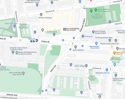
A few decades ago, the Department of Transportation (which in 2023 seems more interested in making things tough on motorists) executed a major traffic redesign at the north end of Utica Avenue, which formerly ended at Fulton Street between Stuyvesant Avenue and Malcolm X Boulevard. It acquired and knocked down some properties and redirected Utica Avenue and MXB so they would flow into each other under control of the same traffic signals at Fulton Street. A similar redesign was done a few blocks west so that northbound Troy Avenue traffic could go directly into Lewis Avenue.
On this map, note Hunterfly Place at bottom right. It is a remnant of a precolonial road the Dutch called Hunterfly Road. The name is an Anglicization of the Dutch “Aander Vly” which means “to the low, or swampy, place” and was on a Native American trail that went southeast to Jamaica Bay. Another section of Hunterfly Road at Bergen Street is home to the historic Weeksville Houses.

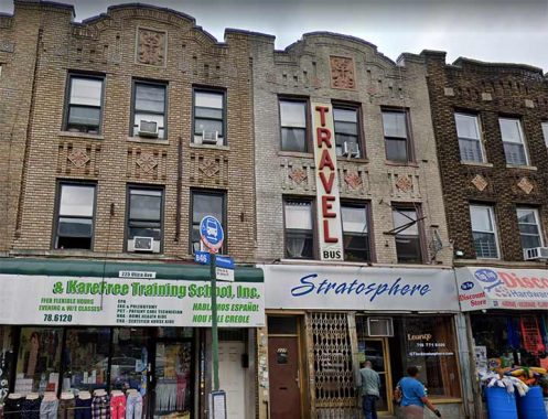
What attracted me to Danny’s photos is Utica Avenue’s collection of leftover store signage from previous tenants such as this travel agent sign at #227 Utica between Sterling and St. John’s Places. If you look carefully you can see the old Greyhound logo. I doubt this was ever a bus terminal, but I imagine tickets were sold here.
Neon liquor store sign with clock, #138 Utica Avenue at St. Mark’s Avenue.
Utica Avenue has a NYC lamppost species that is getting rarer, the square-shafted “shoebox” lights; I do not know the manufacturer, but I named them “shoeboxes” because of the light fixture housing. This make can be found scattered around mid-Brooklyn on Utica and Church Avenues; they were formerly used on 5th Avenue in Park Slope. A lone specimen can be found at Bedford Avenue and North 7th in the heart of Williamsburg. Most still employ yellow sodium lights, and if they can’t be converted to LED, they’re likely endangered. this batch is on the stretch of Utica between Pacific Street and East New York Avenue., with this one at Prospect Place.
East New York Savings Bank, Parkway Branch building, 1117-1123 Eastern Parkway at Utica Avenue, was declared an individual NYC Landmark in 2015. It was designed by the firm of Holmes & Winslow and completed in 1928, the same year as One Hanson (Williamsburg Bank Building) for decades Brooklyn’s tallest. In 2023 it was home to Snipes, an athletic wear chain.
The general concept of the parkway system, devised by master urban architect Frederick Law Olmsted in the 1860s, was to extend large parks by making the roads that connected them into parks themselves. Olmsted’s vision can be seen in Brooklyn’s Ocean and Eastern Parkways, and in the Bronx’ Mosholu Parkway and Pelham Parkway (whose official name is the Bronx and Pelham Parkway because it connects Bronx and Pelham Bay Parks). Mosholu Parkway’s original stretch between the Bronx and Van Cortlandt Parks is still wonderfully intact.
Unfortunately, the “parkway” concept of Brooklyn’s Ocean and Eastern Parkways is largely lost as these roads now serve mainly as conduits for pedal-to-the-metal traffic from Prospect Park south to Coney Island (and its adjoining Belt Parkway) and from Prospect Park east to Bushwick Avenue (where a traffic transfer to the Jackie Robinson (Interborough) Parkway is close by.
In the 1990s, Eastern Parkway as far east as Ralph Avenue was refurbished and given its own set of distinctive stoplights and lampposts. Virtually unique in the city, their bases resemble beefed-up, steroidal versions of the Type B park post or Type G lamp formerly employed on side streets.
Eastern Parkway was constructed between 1870 and 1874 between Grand Army Plaza and Ralph Avenue as a true parkway, with greenways on both its “service roads.” This was still the horse and buggy era and Dobbins were the swiftest method of transportation. The parkway was extended northeast to Bushwick Avenue in the 1890s.
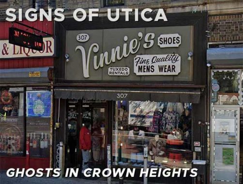
Old school vinyl sign, Vinny’s Shoes, 307 Utica Avenue south of Union Street.
There are certain businesses that lend themselves to the presence of older signage. Laundromats is one such; they exist for years under the same management, so there’s no need to change the sign. Liquor stores are in the same category. However, some are in need to TLC, such as “Launder Center” at #397 Utica just south of Crown Street.
Flavas Kitchen, #419 Utica Avenue south of Montgomery Street, has a sign featuring the colors of the flag of Jamaica, black, green and gold. As this is written in late August, we are nearing the annual West Indian Day Parade which occurs on Labor Day on Eastern Parkway most years.
Looking east on East New York Avenue at Utica Avenue. Recently, another traffic redirection was made, connecting Remsen Avenue and ENY Avenue directly and eliminating Remsen Avenue’s intersection with Utica Avenue. A large storage facility, Cube Smart, can be seen at the intersetion.
Utica Avenue changes character somewhat south of ENY Avenue, away from residential (though multidwelling buildings can still be found) and toward auto collision repair, tire shops and gas stations as well as poultry wholesalers. This distinctive sign can be found at Utica Avenue and Maple Street.
Mike’s Diner, Utica Avenue and Winthrop Street, fell on hard times in the 2010s and is now a venue where bills are most definitely posted, after it closed in 2019. It was built by DeRaffele and Sons.
The 7,515 square foot diner that stretches across the corner of Utica Avenue and Winthrop Street, was initially built in 1931, and according to “Diners of New York” by Michael Engle and Mario Monti, was one of the few classics left from the 1925 to 1945 golden age of diners in the city.
East Flatbush, and neighborhoods like Williamsburg, East New York, Canarsie, Bensonhurst, Bay Ridge, Sheepshead Bay, Flatlands, and Bath Beach, were all home to these retro diners, and in some cases, continue to serve primarily residential and now racially diverse areas. [Politics NY]
This ancient “Laundermat” sign (spellings are variable) can be found on Clarkson Avenue east of Utica. A laundry remains in the space.
As always, “comment…as you see fit.” I earn a small payment when you click on any ad on the site.
8/27/23
