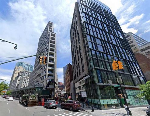
RED Hook Lane, in Downtown Brooklyn, can be added to the list of New York City streets that are nowhere near the locations they are named for, joining routes like Flushing Avenue (Ft. Greene-Clinton Hill-Bushwick-Maspeth) and Bayside Avenue (which is actually in Flushing). It runs one block between Fulton and Pearl Streets and Livingston Street and Boerum Place. I last wrote about it in 2004, when it appeared developers wanted to build over it. Developers have indeed made their mark, placing two glassy skyscrapers at its south end (shown above) but the lane is intact. It now looks considerably different than it did 19 years ago.
Red Hook Lane started as a nameless native American trail that colonists found convenient enough to expand. By the mid-to-late 1700s Red Hook Lane stretched southwest to the Brooklyn neighborhood that bears its name and was the principal route for both British and Continental Armies. Red Hook’s Fort Defiance, a five-gun redoubt located at about today’s Dwight and Beard Streets, played a key role from August 27-29, 1776 during the Battle of Brooklyn.
With Washington’s vastly outnumbered troops hunkering down in Gowanus and Prospect Heights, British Admiral William Howe decided to send in an armada to finish them off, but the guns of Fort Defiance forced Howe’s seven ships to turn away. Howe and the British won the Battle of Brooklyn; Washington’s forces took heavy losses, but were not eliminated and fought on. Fort Defiance was destroyed during the battle.
Local historian John Burkard maintains that American militiamen would position themselves along Red Hook Lane and take potshots at passing British troops. One such rifler picked off a British major and one other soldier before being shot and killed himself. The three men’s remains can supposedly be found under an empty lot at Columbia and Nelson Streets. Fort Defiance is apparently unmarked except for a small sign at the Coffey Street recreational pier, about 5 blocks away from its true location, and a Red Hook bar has claimed the name.
Fairly early in its history…by the mid-19th Century…Red Hook Lane had been truncated to the one-block stretch it presently occupies. Traces of its former longer route are scant, but this brownstone between Atlantic and Pacific just west of Boerum Place has a slanted eastern side, meaning it was built along a diagonal property line running along Red Hook Lane’s old route. Red Hook Lane lost its name for 40 years, becoming the south end of Pearl Street.
As always, “comment…as you see fit.” I earn a small payment when you click on any ad on the site. Take a look at the new JOBS link in the red toolbar at the top of the page on the desktop version, as I also get a small payment when you view a job via that link.
11/17/23
