

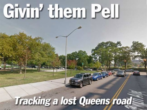
As you can see in the title card, there’s a twin, or double-masted, hexagonal pole on 37th Avenue west of 114th Street, illuminating the sidewalk at Hinton Park, which extends from 34th Avenue one block to 37th Avenue and from 113th to 114th Streets. Of course, most people would ignore this anomaly and pass it by without giving it a second thought. But I’m not most people.
When I moved to Flushing in 1993, I bicycled all over eastern Queens and would make frequent forays into Corona west of Flushing Meadows-Corona Park. And, even before that, I’d sometimes make it all the way here from Bay Ridge on long bike trips.
And, I can state with 100% veracity that this double-mast is here because it lit a short branch of 37th Avenue that ended at 114th Street called Pell Avenue. I had found it on those early bike rides. In fact, when Hinton Park was extended south to 37th Avenue in 1999, it nearly completely absorbed Pell Avenue. The key word is “nearly.”


Here’s a view from 114th Street looking southwest toward 37th avenue at Hinton Park. You can see a short piece of concrete park path that comes to a stop at one of the trees. That’s what’s left of Pell Avenue.


An aerial view of Pell Avenue from the mid-1940s…


… and a more recent aerial, showing the stub end.
So, what do we have here… why did Pell Avenue even exist? It’s a very short section of what was once a much longer road.


This is a 1909 map of northern Corona and what would be the Grand Central Parkway and northern Flushing Meadows Park. There’s a lengthy east-west road called Flushing Turnpike (some maps also called it Newtown and Flushing Turnpike). It connected Elmhurst Avenue to Jackson Avenue, or today’s Northern Boulevard. On this map, it’s likely that the cross streets on the right side were mapped only, as these would be the ash heaps that F. Scott Fitzgerald referred to in “The Great Gatsby” in the early 1920s.


This is a Belcher Hyde atlas plate from 1927, showing that by then, the Flushing Turnpike was known as 37th Avenue and the section of the turnpike running from 37th Avenue northeast to Northern Boulevard/Jackson Avenue was named Pell Street.
Beginning in the early 1930s, all the mapped streets east of 114th were obliterated so that the Grand Central Parkway and Flushing Meadows Park could be built. Construction on the mapped streets eat of 114th likely was never started, except for Pell Street, which carried a trolley line.
Thus, only that little notch of Pell Street between 37th Avenue and 114th Street was able to survive, as Pell Avenue. However, the Flushing Turnpike still exists as 37th Avenue. This is evident in the somewhat curved path the roadway takes from Elmhurst Avenue east to 114th Street.
Why was it called Pell Avenue? The answer lies in the Bronx, of all places. Thomas Pell had purchased a huge amount of territory from the Siwanoy Indians in 1652 and built a mansion that still stands in Pelham Bay Park. The town of Pelham in Westchester County is named for him. Thomas’ son John inherited the manor and his daughter Mary married a Samuel Rodman, who owned a great deal of property in Flushing. Unfortunately, both Pell Avenue in Corona and Rodman Street in Flushing have disappeared, either through demapping or renaming.
So the next time you see a clue that a street was once where you thought it was… you’re probably right.
Photos courtesy FNY Correspondent Sergey Kadinsky.
10/6/14