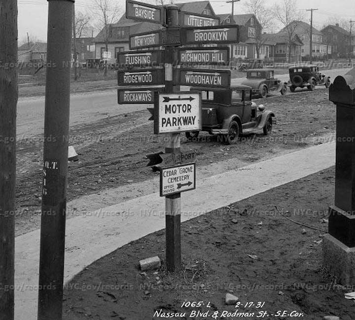
In this photo taken in early 1931, we are standing at two streets that don’t presently exist in the current form, or under the names shown on the photo. In 1931 the city was developing Nassau Boulevard as a through route from Queens Boulevard east into Nassau County, along the line of what was originally 61st Avenue; some of the road is still unpaved and the sidewalks are new. The road did not keep the name Nassau Boulevard for long, though, as pretty early on it was renamed for Horace Harding, a financier and friend of NYC traffic czar Robert Moses. It was widened into the Long Island Expressway in the 1950s, with Horace Harding’s name still affixed to the service roads, and the LIE was built east to about Riverhead in Suffolk County by the 1970s.
Meanwhile, Rodman Street became College Point Boulevard in 1969; that year the Department of Traffic (now Transportation) decided to rename 122nd Street, College Point Causeway, Lawrence Street, and Rodman Street under the single moniker College Point Boulevard. Short stubs still bear the names Lawrence Street and Nassau Boulevard in Queensboro Hill and Little Neck, respectively.
I’ve long been fascinated with these directional signs mounted on striped posts–they were chockablock on busy Queens routes in the 1920s and 1930s, then disappeared without trace. This one is especially loaded, with arrows pointing to 9 separate neighborhoods. For example to get to places like Richmond Hill and Woodhaven, you would turn right onto what was then Strongs Causeway (now the LIE), then find a through route south. The signs weren’t especially helpful about what routes to take, but they did get you started.
Other signs and arrows were added on later, such as the Motor Parkway. The original section was built in 1908 as a speedway, but it later became a convenient auto through route to Ronkonkoma; it wasn’t, however, extended west into Queens until 1926. At first, Nassau/Horace Harding Boulevard connected to the Motor Parkway, but the Parkway was decommissioned in 1938 and the Fresh Meadows Houses were later built where they crossed.
The arrow below that is hard to make out but it points east to Curtiss-Wright Airport. Since it’s pointing east the sign is likely referring to the Valley Stream Curtiss-Wright Airport, in operation between 1929 and 1933.
The final sign refers to the nearby Cedar Grove Cemetery, the gates of which were a block or two away, and still are on the south LIE service road, Horace Harding Expressway South. The cemetery was founded in 1893.
Check out the ForgottenBook, take a look at the gift shop, and as always, “comment…as you see fit.”
8/10/17