

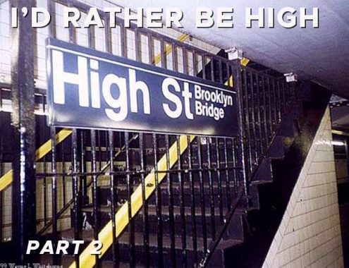


I just keep finding more and more artifacts at the High Street IND subway station serving A and C trains. One of the artifacts is the name of the station itself. Today, High Street exists as a one-block stub between Pearl and Jay Streets, but in its original layout it ran east from Fulton Street between Cranberry and Middagh Streets all the way east to Navy Street at the Brooklyn Navy HYard. Decades of new construction, including the grassy Cadman Plaza, the Brooklyn-Queens Expressway and the Farragut Houses, obliterated most of it as well as some other streets entirely.


This 1949 Hagstrom map was made just at the outset of the new construction that would destroy much of downtown Brooklyn in favor of expressways and housing projects (thanks Robert Moses!) Cadman Plaza is in place, but not yet the Houses, and most of the (occasionally tiny) streets were still intact. The circle in Cadman Plaza stands for the High Street station, and High Street itself was still in place.


Speaking of the Navy Yard, a painted sign can be found at the Adams Street exit of the High Street station. I have been here plenty of times before, but either must have missed this, or it had been previously covered. The sign implies that there may at one time have been a shuttle bus from here to the Navy Yard, which before its closure in 1966, employed thousands in its shipyards, especially during the WWII years. However, the sign may also have pointed people toward the B57 bus, which until recently terminated at High and Pearl Streets and then traveled down Flushing Avenue past the Navy Yard toward Maspeth. These days, the B57 runs all the way south to Red Hook.

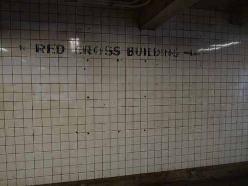
A companion painted sign points to the Red Cross Building. The Brooklyn HQ of the Red Cross, the humanitarian organization that provides emergency assistance, disaster relief, and disaster preparedness education in the United States, was formerly on High Street east of Washington Street. That building is long gone and the NYC Red Cross HQ is currently at 520 West 49th Street in Hell’s Kitchen.


But the painted sign is not the only Red Cross ghost. When Cadman Plaza was built and Adams Street given multiple lanes and turned into “Brooklyn Bridge Boulevard” there was a leftover stub of High Street between Washington, now Cadman Plaza East, and Adams. The stub was renamed Red Cross Place for the building, which is now gone but the street name remains.
A similar occurrence happened in Queens when North Hempstead Turnpike became Booth Memorial Hospital. Booth Memorial was absorbed into New York/.Presbyterian Hospital, “orphaning” Booth Memorial Avenue.

Red Cross Place isn’t the only street stub found here. This dead end Sands Street leads into an emergency vehicle parking lot. Sands Street picks up again and runs through the Farragut Houses into the Navy Yard. Once the province of taverns, brothels and tattoo joints catering to Navy Yard sailors, it’s been tamed considerably from decades ago.


One more relic, this one a lamp fixture from the 1970s, a General Electric M400A2, a second-generation GEM400 that had a yellow sodium bulb and the photocell mounted toward the back of the fixture. This was an “evolved” version of the GE M400, which was equipped with green-white mercury bulbs. Both versions of the GE M400 dominated main streets in NYC from 1960-1975, but today, they’re hard to spot in the 5 boroughs, though still plentiful elsewhere.
As always, “comment…as you see fit.” I earn a small payment when you click on any ad on the site.
12/20/21