

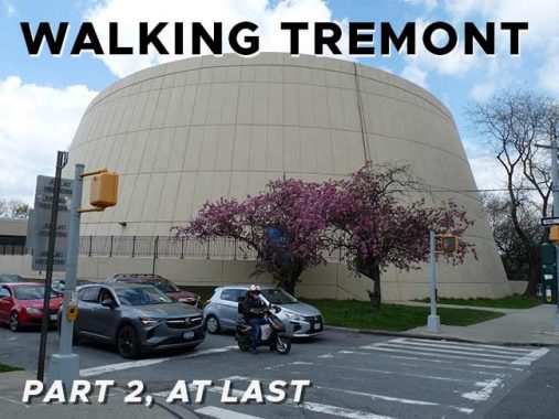


In March 2018, I marched from the Tremont Ave. IND subway station at the Grand Concourse east on its titular avenue all the way to the Bruckner Expressway, where I caught a bus back to Queens. I’d never walked for this long a stretch on the Bronx’s lengthiest avenue before, and I’m always ripe for something new.
The genesis of Tremont’s name is similar to that of Boston’s Tremont Street: while that city’s Tremont was named for three hills on the originally narrow peninsula where Boston grew and prospered, so the Bronx’ Tremont was named by its first postmaster for three hills in mid-Bronx: Mount Eden, Mount Hope and Fairmount. The main difference is that Bostonians pronounce it TREM-mont, while Bronxites say TREE-mont.
Like most of New York City’s lengthy routes, Tremont Avenue wasn’t called Tremont Avenue for its entire length in its early years. The late Bronx historian John McNamara, in his indispensible History in Asphalt, says that east of about Third Avenue, the road was known by many names along different sections of its length, including Morris Street, Walker Avenue, Fort Schuyler Road and Throg(g)s Neck Road. Some of it was briefly part of East 177th Street! By 1900 or so, the part east of Boston Road was a northeastern extension of West Farms Road east to Westchester Square at Westchester Creek. However, by 1920, the full length road was Tremont Avenue, divided into East and West sections by Jerome Avenue. I’m unsure of the reason why East Tremont name took the place of the other sections, but it did leave the East Tremont section about 8 miles long, with the West Tremont side about one!
When I had more time for Forgotten NY explorations (which coincide when I am not working) I always try to go on a street in NYC where I have never been. I will never match Matt Green‘s or the late William Helmreich‘s (both of whom I have met) feats of walking every single square inch of New York’s over 9000 streets, but I pick and choose the streets that interest me. On April 20, 2024, a sparkling spring day, I finally walked the easternmost stretch of Tremont Avenue where I had never walked, the part between the Bruckner Expressway and Schurz Avenue parallelling the East River. Since I began at Westchester Square, on some of this page, I’ll recapitulate some items from my first Tremont Avenue page, but southeast of Bruckner, I was trailblazing new territory! Later, I’ll have to fully explore West Tremont Avenue, the road’s windiest and hilliest section.
Since I squeezed off 100 shots even on this walk, that’s too much for one page and I’ll split in two and come back with Part Three next week.


I am not going to delve into Westchester Square and its treasures overly, as I have done so repeatedly in FNY; it’s a favorite area of mine and I have led two live tours through it. I haven’t talked about the Apple Bank for Savings on Lane Avenue, a building whose streamlined Moderne design looks new even though it’s in this 1940 tax photo, taken when it was the Bronx Savings Bank. And how about that Twin Type F– in 1940, a batch of them lit Westchester Square. Apple Bank was founded in 1863 as the Haarlem Savings Bank and after a series of mergers and acquisitions, was remaned Apple Bank for Savings in 1983.
As it turns out the building was built before 1940 in Federal style and was bequeathed this Moderne makeover that year.
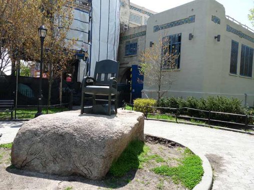
At Westchester Square, East Tremont and Westchester Avenues (the heart of old Westchester Village) there’s always an empty seat in bronze. David Saunders’ 8-foot high sculpture, The Seat, was installed in 1987. Under the chair is a dictionary open to an entry on the birds of North America, and dictionary and chair are mounted on a granite boulder showing wild boar.
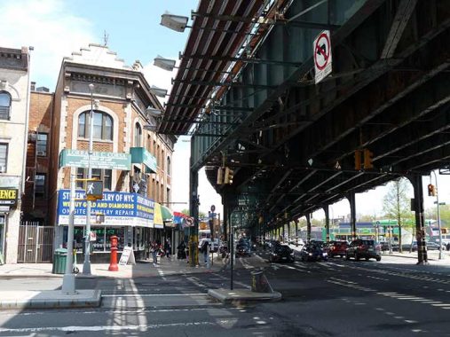
Behind it the #6 Westchester Square station, one of a handful in the system that received monumental concrete cladding, is under heavy renovation.


A separate monument in the square to area residents who served in World War I was dedicated with a speech by area educator Owen Dolan in 1925. After Dolan’s speech, by accounts a spirited, energetic one, he sat down and immediately dropped dead of a heart attack. A section Westchester Square Park at the monument at Lane and East Tremont Avenue was renamed for Dolan the following year.

The recreation center in the park, built with handsome yellow brick in 1927, was also named for Dolan.
This corner brick building at East Tremont and Westchester Avenue looks much the same as it did in 1940 when it featured a cigar store. Look for the faces above the arched windows on the third floor.
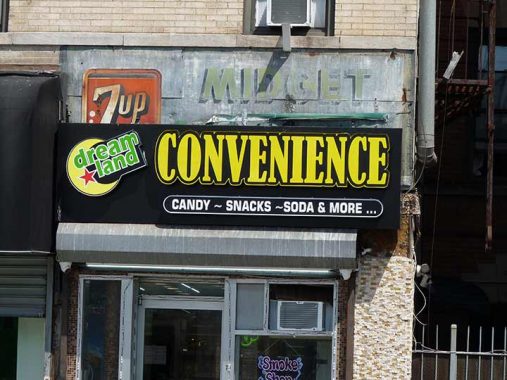
Next door, at Dreamland Convenience, you can see an old 7-Up sign, as well as the word “Midget,” in back of a newer vinyl awning on East Tremont Avenue in Westchester Square. The mind wanders about what the older store was called with the word “midget,” but these 7-Up signs, advertising the lemon-lime carbonated drink, were once all-pervasive around town, as frequently found as the Coca Cola signs.
The drink was formulated in 1929 by Charles Leiper Grigg in St. Louis as the Bib-Label Lithiated Lemon-Lime Soda. The name implies that it once contained lithium citrate, used in the mood-stabilizing drug, which remained part of the recipe until 1948. The origins of the name “7-Up” are unclear but there are several theories: The “7” could come from the seven main ingredients in the drink, while a more outrageous one claims that the “7” referred to the lithium because the element’s atomic mass is 7.


From one monument to another, though this one is much less conspicuous, tucked away next to a White Castle on East Tremont Avenue. It marks the site of the Battle of Westchester Creek, Oct. 12th, 1776 in which a small group of 25 riflemen kept the British at bay by dismantling the planks of the bridge then spanning Westchester Creek, which is now diverted into the sewer system at this spot.
The patriots then fired on the front line of the 4,000 Redcoats attempting to advance on George Washington’s army, then located about four miles away in Kingsbridge. The British were delayed only for a few hours but it was enough to allow Washington to slip away.
Note the inscription mentioning “Dock Street.” It is one of the oldest byways in the Bronx, running between East Tremont and Ferris Place. Along with Kirk Street it was a landing point for ships approaching the town of Oostdorp, now Westchester Square, in the days of New Amsterdam. Both Kirk and Dock Streets survive as driveways on the property of an oil company on Ferris Place.


Herbert H. Lehman High School, named for a former NYS Governor and Senator (1878-1963) is, architecturally speaking, one of the oddest high schools in NYC. It opened in 1974 (cornerstone laid in 1971) designed by Eggers & Higgins and straddles the Hutchinson River Parkway on a bridge. The easternmost building is a windowless dome that contains its 1000-seat auditorium. The campus now consists of the Renaissance School of Musical theater and Arts, Westchester Square Academy, Schuylerville Preparatory High School and Lehman High.


A short street connecting East Tremont and Westchester Avenues was renamed Little League Place for the field it runs past in 1985. It was once named Tan Place for a) a tannery b) union boss Timothy A. Naughton c) short for Tangent, an angle at which it meets the two longer routes. It’s all academic now, anyway. Robert Leder (1939-2018) was a much-admired principal of Herbert H Lehman High School for 29 years.

Quite a sight to round a curve heading southeast on East Tremont Avenue and view the the high steeple of First Presbyterian Church of Throg(g)s Neck (1880), East Tremont between Ericson Place and Dudley Avenue. The graveyard in the rear contains several names reflected on local street signs.
From Historic District Council’s Six To Celebrate series:
This prominently sited brick church, designed in the High Victorian Gothic style, boasts a distinct steeple that can be seen from blocks away. Notably, Crow Hill, on which the church sits, was the site to which General William Howe and his troops retreated after being repulsed by American forces as they attempted to cross Westchester Creek. The use of polychromatic materials, such as the contrasting white stone trim and red brick, as well as the incorporation of banded arches into the facade, is emblematic of High Victorian Gothic architecture. The First Presbyterian Church of Throggs Neck was organized in the 1850s, and during the Civil War, church parishioners offered bowls of soup to soldiers passing through Throggs Neck via train so that they would not be tempted to visit nearby taverns. The congregation’s first structure burned down in 1870, and the date of current church is unknown, although some estimates date it to around 1880.


I didn’t expect to see the King of Rock & Roll in the window at Personal Impression Printing, East Tremont and Ericson Place. But as the late Mojo Nixon put it, “Elvis is Everywhere”
https://www.youtube.com/watch?v=5DcTY9i-fx8
[For some reason the video doesn’t show up in WordPress as usual, but copy and paste the URL into your browser and play it that way]


This is why I call it Throg(g)s Neck with a parenthesis: while many area residents spell it with two G’s, the Department of Transportation has one G on its signage for the Throgs Neck Bridge and other locations. I explain what the name’s all about on this FNY page.
Here, East Tremont Avenue runs through the Bronx neighborhood of Middletown. Eastern Bronx was once peppered with small crossroads like Stinardstown, centered at today’s Westchester Avenue and St. Theresa Avenue; Middletown, along today’s Middletown Road: no one is sure what two landmarks or towns it was in the “middle” of; and Country Club, so named for 26-acre Westminster Country Club, where patrons sailed yachts, played polo and did whatever gentry did for fun in the early 20th Century.
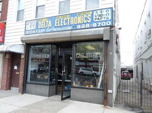
I am not one to let a good painted sign go unphotographed and here’s one for Delta Electronics, #3108 East Tremont east of Latting Street. It’s been there since the beeper era.

The camera was attracted to this small porched house at #3185 East Tremont between LaSalle and Waterbury Avenues.


I know we’re all about East Tremont Avenue, but I detoured on Waterbury and Mayflower Avenues for lunch and took a look at some of Waterbury’s varied architecture. Lawrence Waterbury was a 19th century landowner with property in today’s Pelham Bay Park, which happens to be the largest park in NYC, beating out Central Park by a considerable margin. The Bronx is thought of as NYC’s most “urban” borough, but has the city’s greatest amount of park acreage hectare by hectare, with large green spaces such as Bronx Park, Van Cortlandt, Pelham Bay, Crotona and others.
Waterbury Avenue is divided into three pieces, like Gaul, with sections in Unionport, Middletown and Country Club; the pieces are separated by Westchester Creek/Hutchinson River Parkway and the Bruckner Expressway.

When I am in these parts my taste buds lead the way to Louie & Ernie’s Pizzeria, which is in the small frame house at the corner of Waterbury and Edison Avenues, profiled in this FNY page.


“Puritanism. The haunting fear that someone, somewhere, may be happy.” — H.L. Mencken
In Middletown, Puritan, Pilgrim, Plymouth, Mayflower, William Place, and [William] Bradford Avenues recall the Pilgrims’ arrival in Massachusetts in 1620.


I recently purchased a marker for the gravesite of my mother, father, grandmother, grandfather and stepgrandfather in St. Joseph’s Cemetery in Troy, NY 50 years since my mother was interred, and my thinking is, “if not now, when and if not me, who.” I used an upstate manufacturer and not any of these arrayed along East Tremont Avenue, many of which have outstanding signage. In fact the one for Crown was so nice I shot it twice.


Where there are monument and flower dealers you usually find cemeteries and here is the Bronx’s largest Catholic cemetery, St. Raymond’s. Two vast cemeteries are associated with St. Raymond’s Church in Westchester Square and are operated by the Catholic Diocese of New York. Old St. Raymond’s, located roughly between Waterbury Avenue, Bruckner Expressway, the Hutchinson River Parkway and East Tremont Avenue, was originally the “Underhill Farm of Throgg’s Neck” purchased by Rev. Michael B. McEvoy who was pastor from 1875 to 1885. Old St. Raymond’s Cemetery was founded in 1875.
The church purchased additional property in the early 1950s to create New St. Raymond’s, between the Hutch, Cross Bronx Expressway, and Randall and Lafayette Avenues. New St. Raymond’s is the final resting place of boxer Hector “Macho” Camacho, 1950s pop’s Frankie Lymon, actress Lois Nettleton, salsa’s “La Lupe” Yoli and jazz songstress Billie Holliday.

A shuttered Boston Market at East Tremont and Meyers Court. For my money, “Boston Chicken” was always king of the chicken wars instead of the overbreaded nonsense at Popeye’s or Chick-Fil-A. I’d get the rotisserie breast and wing and set on it like a jackal till only the bones remained. Mismanagement, not unpopularity, led to the chain’s demise.

I photograph interstate shields, they’re a reminder that the interstate system of roads founded in the 1950s have plenty of representation in NYC. Here, they direct traffic to the Bruckner Expressway.
The Bruckner Expressway, named for a 1930s Bronx Borough President, bruits its way northeast here, connecting the Major Deegan and East River bridges with Westchester County, becoming the New England Thruway and once in Connecticut, the CT Turnpike.
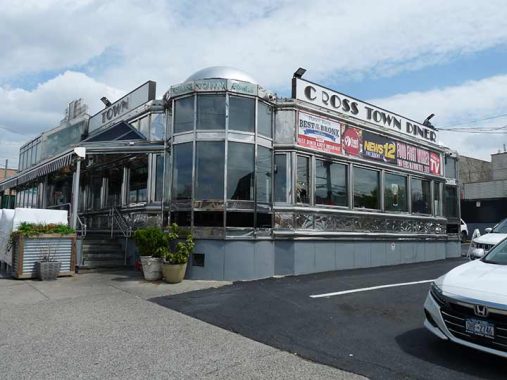
I could have stopped into the well-regarded Crosstown Diner for lunch, but it would have ruined dinner, a meal I don’t like to ruin; I’ll get in someday.
Next time: To the end of Tremont and beyond
As always, “comment…as you see fit.” I earn a small payment when you click on any ad on the site. Take a look at the new JOBS link in the red toolbar at the top of the page on the desktop version, as I also get a small payment when you view a job via that link.
10/13/24