

I have written often about the stationhouses found on the NYC subway’s old BMT division, mostly along the Sea Beach line (for younger readers, the N train between 59th Street and Coney Island) with some on the West End (D) and Brighton (Q, B). Built in the 1910s, I’ve always found them to be mini-masterpieces and unsung treasures of the subways. In recent years the MTA has come to agree with me as these buildings have been rehabilitated and are in as good a condition as they’ve ever been.
Another bit of architecture in the subways that is almost completely ignored is the select stations that have been cladded in concrete and terra cotta. These stations, as well as the BMT stationhouses, were commissioned by the grand designer of subway stations in their early days from 1908 to 1940, Squire Vickers, a painter by trade. A definitive biography of this great man has yet to be written: perhaps I should do it.
In 1911 the BMT and IRT subway divisions entered into a construction funding plan called the Dual Contracts, named for the two subway divisions. It was the greatest burst of subway and elevated train building in transit history as over a dozen new subway and elevated lines were built and already existing elevated lines were extended. Vickers had a hand in the design of all the new stations, and he also supervised the more uniform scheme for the Independent Subway that followed from 1925-1945.
Existing elevated trains, some going back to the 1800s, did not get the deluxe concrete cladding, so Manhattan never had such stations. what they did have was chalet-type structures for their elevated stations on the 2nd, 3rd, 6th and 9th Avenue els, as does Manhattan’s uptown el, an outdoors extension of the Broadway IRT line. In Brooklyn and Queens, the Broadway-Jamaica Avenue el, the Culver (F train), the Fulton Street el (of which the Liberty Avenue line in Queens is a remnant) nor the former Myrtle, Lexington and 5th Avenue lines had concrete-cladded stations, as they were built in the 1880s and thus preceded the Dual Contracts, whose els were built between 1915 and 1920. Those years are the “sweet spot” for today’s topic.
In most cases…but not all, as we’ll see…concrete-cladded stations were built over busy roads and not at important junctions. Vickers apparently thought it would be efficacious to add the design element at busy streets.
Instead of training all over town, I took many of the photos on gthis page from Google street View, hence the blurriness in sots; GSV has an annoying habit of occasionally blurring signage, for what reasons I cannot fathom.

![]()
![]()
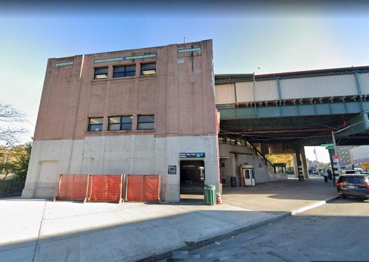
This station was built at the obscure intersection of Birchall Avenue and Sagamore Street, a block from the entrance to Bronx Park at the edge of the Morris Park neighborhood. It’s the most obscure of NYC’s concrete el stations and I’m stumped why this one was chosen. It’s on the White Plains el and like the other stations along the line north of 180th Street, it opened in March 1917. As you can see the concrete is covered with stucco, with some color terra cotta elements on the roofline.
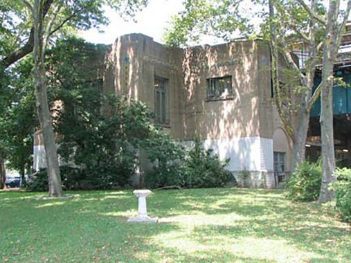
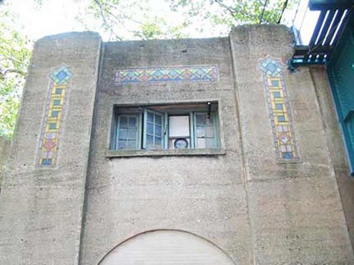
The terra cotta in these stations is understated and usually consists of gold-colored squares and green or blue diamonds, with subtle variations from station to station.


![]()
![]()
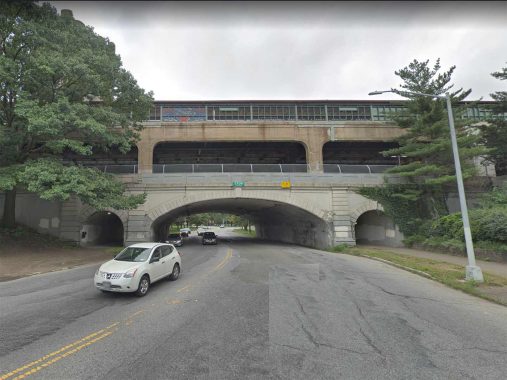
Unusually, there are two consecutive “monumental” stations on the White Plains el, as Pelham Parkway is the very next stop. It’s also one of the lengthiest uses of concrete, stucco and terra cotta on elevated trains, though as we’ll see, it’s far from the longest. At Pelham Parkway, the el station spans 5 lanes of the parkway plus two medians, and has exits and entrances on both sides.
The Bronx and Pelham Parkway (such is its official name) was constructed in the early 20th Century between Bronx and Pelham Bay Parks and bears close resemblance to Mosholu Parkway (see below), i.e. a four-lane main road with access roadways flanking it. Unlike Mosholu, though, Pelham Parkway originally ran through open country; parcels for it were obtained from local landowners.

![]()
The Pelham El, or the #6 train, runs above ground between Whitlock Avenue and Pelham Bay Park, and no less than three stations in the elevated section have “monumental” elements though most are fairly short by the standards of the White Plains el. The first of these can be found at Parkchester in the center of Hugh Grant Circle (not named for the British actor but for the youngest mayor in NYC history). The Cross Bronx Expressway runs beneath the circle, but when the station opened in May 1920, traffic czar Robert Moses was at the start of his career. Yet, this was even then an important crossroads as the Expressway was laid out along East 177th Street, one of the only numbered streets to span the Bronx from west to east, and it met Westchester Avenue here with White Plains Road just one block to the west.
The concrete section is short and fits within the circle. The station has been renovated since I shot these photos and looks practically new.


![]()
Until 1874, The Bronx was a part of Westchester County — New York County annexed the portion of Bronx County west of the Bronx River that year (Morrisania, West Farms and Kingsbridge), and east of the Bronx River in 1895 (the town of Westchester and parts of Eastchester and Pelham). The following year City Island voted to become part of NYC; New York County became a part of Greater NY in 1898, and finally, The Bronx became its own borough in 1914. The old town of Westchester is still represented by Westchester Square, where Westchester Avenue and East Tremont Avenue come together, and the square still resembles the county village it once was.
Westchester Square, even to the present day, appears to be a small town hub, clustering around the triangle formed by Westchester, East Tremont and Lane Avenues. The “town” has recently celebrated its 350th anniversary, having been settled here, as Oostdorp (‘east village’) by the Dutch in 1654 and taken over by the British with the rest of New Amsterdam in 1664. It became a busy port along Westchester Creek, which hastened its development; by 1693 St. Peter’s Episcopal Church was founded. The parish is still in existence. During the Revolution, patriots dismantled a bridge over the creek, delaying British advancement (the present-day bridge carries East Tremont Avenue over the creek).
As with Parkchester, Westchester Square claims a “monumental” el station, but it’s small and confined to a smaller area at the Westchester Square entrance.

![]()
Westchester Avenue meets the Bruckner Expressway and Pelham Bay Park here at the end of the line. Oddly, I can easily reach this spot from eastern Queens, as a bus from Flushing winds up here, and in addition I can get a bus to City Island from here. When the station opened in December 1920, there was no expressway, but the station apparently rated “monumental” status because of Pelham Bay Park.
Most New Yorkers would likely immediately respond “Central Park” when asked what the largest park in New York City by acreage is. There are, however, several parks in NYC much larger. Both Van Cortlandt Park and Pelham Bay Park, in the Bronx’s northeast corner, are over double Central Park’s size.
At over 2,700 acres, that title of NYC’s largest park belongs to Pelham Bay Park, which stretches from the old Bronx neighborhood of Middletown on the south to the Westchester County line on the north, and from the Hutchinson River and its namesake Parkway on the west to Eastchester Bay and Long Island Sound in the east.
The Park contains large salt marshes, home to egrets, raccoons, blackbirds, wrens and marine life such as sticklebacks and seahorses; predators like harbor seals and ospreys (fish eagles) feast on the fish and crustaceans. On land, white tailed deer and wild turkeys have been spotted. The Kazimiroff Nature Trail, on Hunter Island (now a peninsula attached to the park by landfill) as well as the Siwanoy and Split Rock nature trails provides easy access to the park’s wilder areas. The eastern section of the park facing Long Island Sound had been named Orchard Beach as long ago as 1905 for the orchards that grew on local estates. NYC Parks Commissioner Robert Moses rebuilt Orchard Beach into its present configuration in 1936, attaching Hunter Island and creating one of NYC’s two largest parking lots (along with the one in Riis Park), and added more territory in 1947 by filling in Twin Island.


![]()
The Bronx Woodlawn El, which runs up River and Jerome Avenues, also features three stations deemed important enough to get the concrete treatment. The southernmost is at Yankee Stadium, which didn’t exist when the station opened in 1917; the Yankees were playing in the Plo Grounds in 1917 and opened the stadium in 1923. Still, 161st was and remains the gateway to the Macombs Dam Bridge spanning the Harlem River, and here has 7 lanes of traffic and two center malls.
In 2009, the New Yankee Stadium opened on the north side of the station, and the old one on the south side was torn down, replaced by the athletic fields displaced by the new stadium.


![]()
The Mosholu Parkway station, opened in April 1918, is a span on top of a span, as Mosholu Parkway is depressed beneath Jerome Avenue.
Mosholu Parkway is among the many Native American place names that have been woven into the city’s fabric. Mo-sho-lu, or “smooth stones” was the Algonquin name of a rural brook running through the heart of what became the Bronx’ Spuyten Duyvil and Riverdale neighborhoods.
In 1888, Mosholu Parkway was laid out as a true parkway, a relatively narrow carriage road lined with trees and foliage, along a former waterway known to the Dutch as Schuil (anglicized as School) Brook. Mosholu Parkway originally ran only between Bronx and Van Cortlandt Parks, with through traffic running in the center and local and commercial traffic on the service roads. The general concept of the parkway system, devised by master urban architect Frederick Law Olmsted in the 1860s, was to extend large parks by making the roads that connected them into parks themselves. Olmsted’s vision can be seen in Brooklyn’s Ocean and Eastern Parkways, and in the Bronx’ Mosholu Parkway and Pelham Parkway (whose official name is the Bronx and Pelham Parkway because it connects Bronx and Pelham Bay Parks). Mosholu Parkway’s original stretch between the Bronx and Van Cortlandt Parks is still wonderfully intact.


![]()
Woodlawn Cemetery, which, along with Brooklyn’s Green-Wood Cemetery is the premier garden cemetery in NYC, was incorporated in 1863 by theologian Rev. Absolom Peters (a short street named Peters Place is off East 233rd) with its first interment in 1865. I haven’t explored it in quite awhile, since unlike Green-Wood there isn’t a good comprehensive map with its famed interments available. But there are plenty of famed interments. The cemetery is the final home of department store founders James Cash Penney and Roland Hussey Macy, jazzmen Duke Ellington and Miles Davis, and Mayor Fiorello LaGuardia, and many other luminaries.
Fittingly, the northern terminal at Jerome and Bainbridge Avenues rates “monumental” status. There’s a patriotic mural on the Bainbridge Avenue side.


![]()
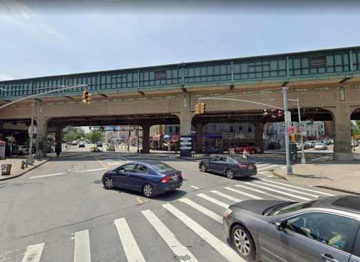
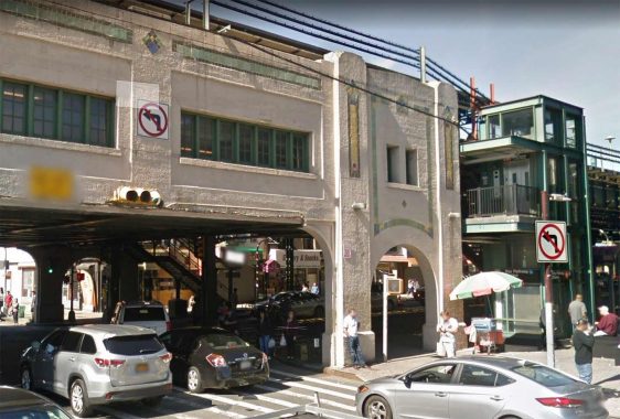
Alone among Brooklyn’s extensive elevated train systems, the West End line (now the D train between 36th Street and Coney Island, running mostly along New Utrecht Avenue and 86th Street) was given several “monumental” stations by Squire Vickers. The els along Broadway and Fulton Street are older and were built before Vickers took over, and none were included on the Culver El that was built in the late 1910s. The West End el replaced a surface steam railroad and was completed between 1916 and 1918.
The crossroads of Fort Hamilton Parkway and New Utrecht Avenue form an X in the heart of Borough Park. In the 1800s, Ocean and Ea1stern Parkway creators Olmsted and Vaux also planned a similar parkway southwest into Bay Ridge, and thus Fort Hamilton Parkway was birthed. It didn’t evolve as did the previous two, though, and today is a pedal to the metal truck route. For its part, New Utrecht Avenue was laid out in 1830 as a planked toll road, with a steam RR eventually running down its center that ran from Green-Wood cemetery to Coney Island. Since 1916, it’s mostly been shrouded by the West End el.
What look very much like interlocking Guastavino tiles can be spotted on the underside of the station platforms, on the exterior on both sides, Are they true Guastavinos? I do not know.

![]()
Bay Parkway is a key highway running from Ocean Parkway in Midwood southwest to the water’s edge at the Narrows; oldtimers may remember an E.J. Korvette’s at the foot of the parkway, in a mall now anchored by Caesar’s Bay Bazaar. Older subway maps refer to it as 22nd Avenue, as kit slots in between 21st and 23rd Avenues. for part of its route it serves as the divider between the old Brooklyn numbered streets (1 through 101st) and the West numbered sgtreets of the old town of Flatbush scheme. Like Fort Hamilton Parkway, it’s usually a cacaphony of racing and honking cars.
The Bay Parkway concrete station features arched units ait its pedestrian crossings. The elevator is a relatively new addition.


![]()
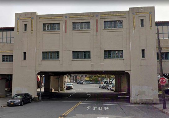
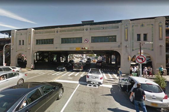
Ocean Parkway is the only “monumental” built for the Brighton line. though it was originally built as an express station only the tracks serving the local Q train are in service today. The station was completely renovated a few years back, with a refinishing job on the concrete, ornamental lamps placed on the span beside the tracks, and some new terra cotta artwork added. Like the Pelham Parkway “monumental” it spans eight lanes of traffic and two medians.
Sculptor Deborah Masters created the Coney Island Reliefs in cast concrete. The 1260 sq. ft. of relief panels fit within existing recesses in the viaduct. Tinted a terracotta color to harmonize with the sandstone color of the Ocean Parkway viaduct, a massive structure that carries the subway across six lanes of traffic and an Olmstead parkway, the reliefs portray scenes from the history and legends of Coney Island, including Neptune, a mermaid, beach, boardwalk, and amusement park scenes. The designs are based upon photographs, drawings, and interviews by the artist with local residents and visitors to the famed amusement park. On the north and south facing facades, there are six triangular shapes in which Neptune and the Mermaid repeat in paired groupings, as well as large rectangular panels at either end of the viaduct facade that feature scenes of Coney Island. MTA Arts For Transit


![]()
The Queens Boulevard Viaduct, encompassing the 33rd, 40th and 46th Street stations, is the lengthiest concrete-clad subway viaduct in NYC.
From its beginnings in June 1915 running one stop from Grand Central to Vernon/Jackson what has become known since then as the Flushing Line has been extended eight times: east to Hunters Point Avenue and Court Square (11/5/1916); Queensboro Plaza to 103rd Street (4/21/1917); 111th Street (10/13/1925); Willets Point Boulevard (5/7/1927); Main Street (1/2/1928) and west to 5th Avenue (3/22/1926); Times Square (3/14/1927) and Hudson Yards (9/13/2015). (A tiled sign at the Hunters Point Avenue station says the line goes “to Astoria and Corona,” referring to the split at Queensboro Plaza that sends the BMT to Ditmars and the IRT to 103rd/Corona Plaza.)
The Flushing Line was long-delayed when it opened. In the late 1880s it was going to be the first iteration of East Side Access, sending Long Island Rail Road trains to Grand Central Terminal to meet the New York Central. This plan was caught up in red tape and high cost estimates. Piano magnate William Steinway began work on the tunnels as an extension of his network of Queens surface lines to Manhattan but ran up against community opposition in Queens as well as underground springs. Steinway passed away in 1896 and IRT king August Belmont was next in line to try and get the line started, completing a tunnel to be used by trolleys in 1907. But Belmont got tied up in red tape again and the tunnels were idle until 1915 when they were purchased by the city as part of the Dual Contracts expansion, modified to accept IRT cars and finally placed into service along two stations.
The Flushing Line is living proof of the aphorism the Ghost of the Cornfield imparted to Kevin Costner in “Field of Dreams”: “if you build it, they will come.” Early photographs from 1917, the year the viaduct opened, shows it running through open fields.
The MTA has apparently been removing the terra cotta inlays from the viaduct, citing safety concerns.
As always, “comment…as you see fit.” I earn a small payment when you click on any ad on the site.
9/19/21
19 comments
Also the former Anderson/Jerome station on the Polo Grounds shuttle.
What about 4 Ave and 9 St has kind of a monument even though it is technically in between 9 and 10 Sts
Didn’t think anyone could make concrete this interesting. Bravo.
Re: Westchester square commentary, paragraph two, last sentence. The Tremont Ave bridge carries Tremont Ave over the Hutchinson River
Parkway. Westchester Creek doesn’t quite reach Tremont Ave, having been beheaded by development since Revolutionary War days when
It extended northward almost to present day Pelham Parkway.
It seems most of the Monumental stations have “Park” in their names, e.g.: Mosholu Parkway, Bronx Park East, Pelham Park, Bay Parkway, et al, or are next to a park or named for a park like location, e.g.: Woodlawn. As for the Queens Blvd viaduct, I’ve always thought that since Queens Blvd is a wide, parkway style street, the el is monumental to compliment its grandeur. I don’t know if that was the thought behind the statons, but that’s how I’ve looked at it for many years.
It surprises me that the 242nd-Broadway Station on the #1 does not have the concrete treatment, but no doubt because it was built in 1908 prior to the Dual Contracts. Such treatment would have nicely bookended the #6 train station at Pelham Bay Park, the other huge Bronx park. 242nd St. does have a rather nice Swiss chalet type station building that is reminiscent of the old Manhattan elevated lines.
Queensboro Plaza also had concrete cladding, although much has been removed, including the entire north half of the station.
In addition to the Queens Blvd. viaduct, there is a much longer concrete clad viaduct – the Rockaway line extending from Mott Ave. to Beach 116th St.
That was built for LIRR
And a Moses project too.
Love these pictures . I am always left amazed by New York !!!
I’m fortunate to live along the 7 Train viaduct. Not only is it far more aesthetically pleasing than the metal ones, it’s quieter.
Excellent article! I use to live in between Pelham Parkway and Bronx Park East and would go to either to travel downtown—however, if I need to go to the market while coming home, I would get off at Pelham Parkway. I loved those stations, especially after their renovations in the early 2000s. I miss living there too!
“…[A] former waterway known to the Dutch as Schuil (anglicized as School) Brook….” Or, as the Dutch may have called it, Schuil Kill, which is also where the river in Pennsylvania that separates Center City Philly from West Philly got ITS name (the “Schuylkill,” which refers to a “hidden stream,” i.e., a stream you wouldn’t have seen, for all the woods and brush on its banks, until you were right on top of it.
Did these concrete els actually cost more or less to build than the regular steel ones?
Probably more. In the case of the stations, the normal steel el construction is used. The concrete is just additional decorative cladding (like brick veneer) added to the structure to make it look nicer.
Since they are basically els made of steel with additional concrete cladding, I’d imagine they’d be somewhat more expensive.
This “oldtimer” certainly does remember Korvette’s. I worked there selling bed sheets the summer before I left for college. Miserable job!
One monumental structure, no longer in existence, is where the 3rd Avenue El in The Bronx crossed Mosholu Parkway. It ran on a decked structure, with decorative arches. It can be seen here:
http://www.palter.org/~subway/73-10-03/33.jpg
As famed internment are concerned, Diahann Carroll is resting at Woodlawn